
|
|
Mountain/Rock |
|---|---|
|
|
37.53460°N / 114.733°W |
|
|
Lincoln |
|
|
Hiking |
|
|
Spring, Summer, Fall |
|
|
8035 ft / 2449 m |
|
|
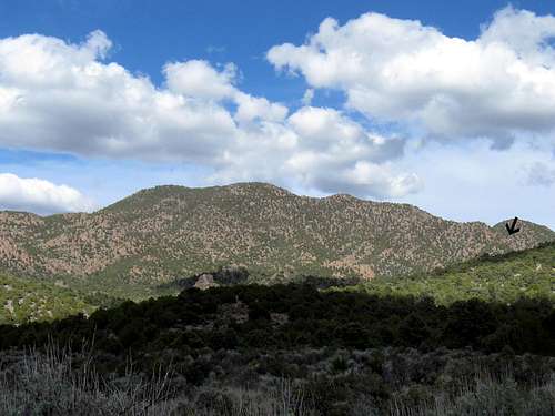
Chokecherry Mountain
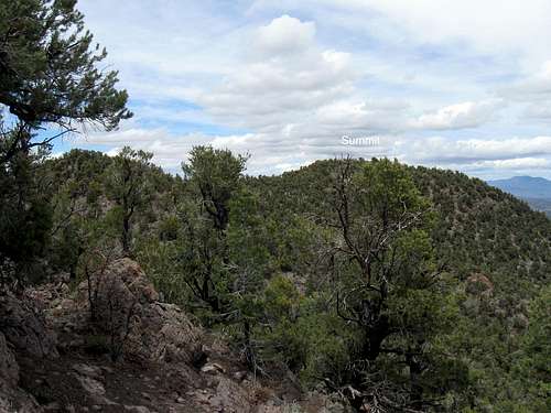
The wooded summit
Overview
Chokecherry Mountain is an isolated peak and wooded mountain in the Caliente Nevada area and is rarely visited. It is the highest peak in the Delamar mountain range and with 2295 feet of prominence, it comes in at #122 on this list. I'm not sure where the "Chokecherry" name comes from but the mountain is covered with pinyon and junipers (aka cedars in Utah) but when you get to the summit, the views are blocked in most directions by the tree cover. Several spots along the ridges and bumps leading to the summit do offer some views but the top itself is somewhat disappointing. It is also a lonely mountain as the register up there only had 8 people signed in since it was put there in 1993. Not even one local was signed into the register and a couple remnants of cabins near the Robinson Seep gives thought that mining activity was at one time the main area of interest.I'm not sure where the name Chokecherry came from as I really couldn't tell if there were chokecherry trees on this mountain. Maybe someone who has knowledge in this arena could make a comment and help me out on the name.
Getting There
From Las Vegas, take I-15 to Highway 93 and head north past Alamo, watching for the turn (near Hiko) for Caliente. Using the waypoint coordinate on Map one, follow the instructions as provided below for Caliente. A rough estimate would be that this is around 150 miles from Las Vegas.
From Las Vegas
The closest town to this mountain is Caliente Nevada and driving directions here are from Caliente. From Caliente Nevada, head west on highway 93 to a junction with a signed "Delamar 15" graded dirt road. Follow the dirt road from US 93 to a junction that is signed for Grassy Spring and turn east toward the spring. At the next junction, stay on the road that keeps going east (the road that is signed for Applewhite summit)
Turn at "Delamar 15" sign that is south of Highway 93
Waypoint two: 37.5599 -114.8111 Grassy Spring turn
Waypoint three:37.5439 -114.78995 The Applewhite summit sign
Waypoint four: 37.51515 -114.7473 Leave road for jeep track
I highly recommend that you make use of maps/gps, it will help find
the correct turns easier and is really worth the time.
These are the key waypoints and are in lat/long nad 27.
However, the ultimate responsibility for safe navigation in this area
falls upon those who take the opportunity to venture here and it is
recommended that you take adequate water & supplies in case of a breakdown and let someone know where you are going to help make this a safe trip.
 Map 1 Map 1 |  Map 2 Map 2 |  Map 3 Map 3 |
 Sign Sign |  Sign Sign |  Rough road in Rough road in |
Red Tape
This mountain is on BLM land and as far as I am aware of, there isn't any red tape to deal with.For more information:
Ely Field Office, Bureau of Land Management, HC 33 P.O. Box 33500, Ely, Nevada 89301-9408 Telephone: (775) 289-1800
or
Caliente Field Station, Bureau of Land Management, P.O. Box 237, Caliente, Nevada 89008 Telephone (775) 726-8100
Camping
You can find a motel in Caliente (there were three that I noticed) or camp at Cathedral Gorge state park 15 miles north in Panaca or you could bush camp near the mountain, being mindful to use the "leave no trace" style.Weather


Route
Summer can be very hot in this area so watch the weather conditions relating to the temperatures. Also, as mentioned above, let some one know where you are going and I'd avoid going into an isolated area like this solo. The roads may become impassable when wet.My hiking companion Ken Jones and I were here because the weather up north was not amenable to our hiking goals and Chokecherry Mountain became one of the substitutes. Thanks to John Vitz for some basic information that helped us find the best way to the base of the hike when we couldn't find that information anywhere else. Our driving directions worked because he had
passed those directions along to us. I am now passing what worked for us along to anyone who might be interested in this one.
It was 1.7 miles from where we left my truck to the summit (yellow mark)and consisted of an elevation gain (including the ups & downs we encountered) of about 1600'.

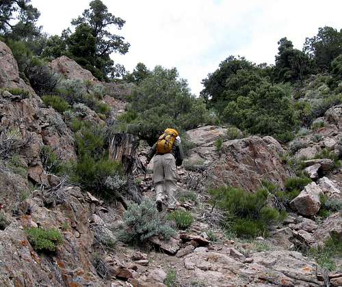
Heading up
The register
Oftentimes when you hike/climb one of these unknown Nevada peaks, you might find a register that demonstrates that visits are rare. Most of the time, you will find the same four or five people in the register and not many others. This mountain, even to this day (2015) is a good representative of this.1989 - Gordon MacLeod and Barbara Lilley (Calif)
2003 - John Vitz (Calif)
2009 - Richard Carey (he leaves the red cans for the register)
2010 - Ken Jones (Wash)and Dean Molen (Utah)
2010 - Eric Kassan (Nevada) plus two others in his group
2011 - Dennis Poulin (Oregon) and Dean Molen (2nd visit)
2012 - Andy Martin (Ariz) Bob Packard (Ariz) Adam Helman (Cal)
 Register Register |  Register page Register page |  Register indicating few visitors Register indicating few visitors |

2011 visit