-
 1545 Hits
-
 73.06% Score
-
 3 Votes
|
|
Mountain/Rock |
|---|---|
|
|
48.89230°N / 121.3475°W |
|
|
Download GPX » View Route on Map |
|
|
Scrambling |
|
|
7087 ft / 2160 m |
|
|
Overview
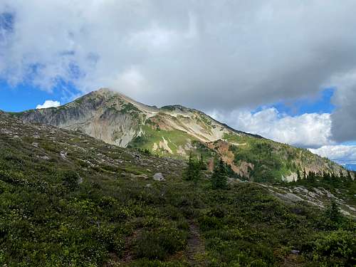
Taps Mountain is a small peak located just north of Whatcom Pass in the North Cascades National Park. At 7087ft of elevation, it is just a tad lower than it's westerly neighbour Red Face Mountain. Both the South Face and the North Ridge are scramble routes (mostly talus). As the mountain is located 20 miles from the nearest road, it typically takes 2 or more days to climb it. The views to the South present Mt. Challenger in all it's glory, and behind it, the Pickets. To the North East, the Chilliwacks taunt the climber with their steep cliffs and snowfields. The peak lies on a ridge traverse that allows climbers to reach the Chilliwacks without crossing to Canada and using the standard Depot Creek trail.
Getting There
- Take exit 255, Sunset/ Mt. Baker Highway, off I-5
- Travel East 31 miles to the town of Glacier
- From the Glacier Public Service Center, travel east on Mt. Baker Highway 542 for 12.5 miles
- Turn LEFT on Forest Service Road #32 (Hannegan Rd). Follow Road #32 for 5 miles. Stay left at forks in the road (ie. don't go to the Nooksack Cirque), if pass the Goat Mountain Trailhead you're on the right track
- The trailhead and parking area are located at the end of the road
Due to a washout, the road ends about 1000 yards before the actual trailhead. A short walk in the woods will bring you to the actual trailhead where a small shelter and a toilet are located. There are some dispersed campsites here and at road end.
Approach
Start at the Hannegan Pass trailhead at 3,110 feet, and hike the pleasant trail that reaches Hannegan Pass at 5,066 feet after a little over 4 miles. Just below the pass, you will pass the first camp of many along the trail (Hannegan Camp). Continue over the pass and begin the descent along the Chilliwack river. The trail will descend to the Chilliwack river crossing at 2,600 feet over 6 miles and change. A little under a mile after the pass, you will encounter Boundary Camp and the fork left toward Copper Ridge. Two more camps are Copper Creek Camp (4 miles from the pass) and US Cabin Camp (6.5 miles from the pass). One of the highlights of the trip is crossing the river in a suspended cable car!
In a mile after the river crossing cross a bridge, and then take a right at the fork to the (aptly named) Brush Creek trail. The left fork will lead you to the other side of Copper Ridge or further into Canada. Climbing up to Whatcom pass at 5,240 feet over 4.75 miles you will pass Graybeal Camp (2.2 miles from bridge) and Whatcom Camp (5.2 miles from the bridge).
From Whatcom Pass, take a left and hike on an unmaintained trail for 1 mile towards Middle Lakes at 3,600 feet. There are amazing camp spots around the lakes. Make sure you only camp on dirt or snow here to protect the fragile vegetation.
Another option to get to Whatcom Pass is from the East via the Little Beaver Trail (17 miles) and Big Beaver Trail (22 miles). This will require taking a boat on Ross Lake (or hiking extra distance).
Route
The route is relatively straight forward. From between the Middle lakes, ascent NE over heather (snow early season) to a plateau at about 6,600 feet. From the plateau follow the path of least resistence over scree and snow to the summit.
Red Tape
Hannegan Pass is a very beautiful area that attracts alot of day hikers, backpackers and mountaineers. For any camping, you will need to acquire backcountry permits from the Park Service. The closest Ranger Station is located in the town of Glacier on State Route 542.
10091 Mt. Baker Hwy
Glacier, WA 98244
(360) 599-9572
A Northwest Forest Pass is required to park at the Hannegan trailhead ($5/day or $30/year). America The Beautiful Interagency Pass will work here as well ($80/year for access to all the national parks and US Forest Service trailheads).
When to Climb
Taps mountain is climable all year round. In the Winter and Spring, Hannegan road is covered in snow, but is an easy ski. Please make sure you're aware of avalanche conditions if climbing over snow.
Camping
See Approach section for campsite location.
External Links
North Cascades NP Trip Planner (camp location)


