-
 32263 Hits
-
 91.3% Score
-
 35 Votes
|
|
Mountain/Rock |
|---|---|
|
|
46.78000°N / 8.43000°E |
|
|
Hiking, Mountaineering, Trad Climbing, Sport Climbing, Ice Climbing, Big Wall, Skiing |
|
|
Spring, Summer, Fall, Winter |
|
|
10623 ft / 3238 m |
|
|
Overview


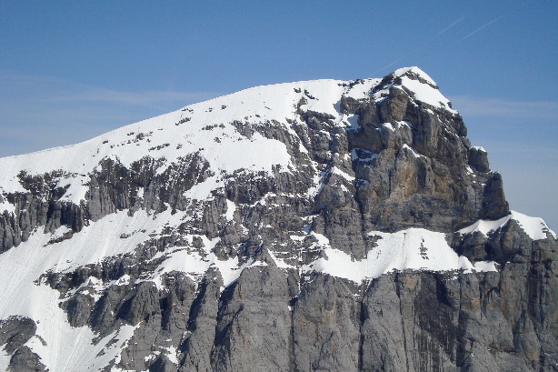
Located near the geographic center of Switzerland, the Titlis is a popular mountain with skiers and climbers and the highest point in the Canton of Obwalden. One can ski down from the summit in the middle of July to the 10,000 foot Klein Titlis, a sub-peak that boasts a restaurant and ice-grotto. The Klein Titlis can be reached by gondola from the town of Engelberg. The gondola is one of two rotating gondolas in the world, the other one being the Palm Springs Aerial Tramway, in Southern California. From the Klein Titlis, the summit is reached by a half hour hike up the West Ridge, with a 600 foot elevation gain. Views from the summit stretch pretty much over the whole country of Switzerland, from the low lands in the north, to the Tödi in the east, Sustenhorn directly south, to the Jungfrau, Mönch, and Eiger to the south-west, and beyond to the Matterhorn and the Monte Rosa Massif. From the summit, one can descend by ski or snowboard down the large snowfield back to the Klein Titlis, or down the slopes a little further, where a ski lift runs all year. If a gondola isn't your thing, there a a few trails that lead to the base of the glacier at 8,000 feet from Engelberg, followed by a path that ascends the glacier to the Klein Titlis. The hike from the Klein Titlis to the summit is quite easy. I did it when I was 12 years old, so any adult in OK shape should make with no problems, at least in the summer months. In winter, the whole mountain is opened as a ski area, yet it is possible to make a winter ascent, however, crampons and ice axes would be needed. Titlis was first climbed way back in 1744 by Swiss climbers I. Hess, J.E. Waser, and two guys from the monastery in Engleberg.
Check out the Titlis website for info on prices, activities, and weather.
Here are the webcams located at the Klein Titlis, Trübsee, and in Engelberg.
Here is the full price list.
 |  |  |  |  |
Getting There
The most approachable routes to the summit ascend the north side of the mountain. These routes start in Engelberg, which is easily reached from traveling south on Swiss Highway 2 from Lucern. You'll see a sign for Engelberg, and the road will head south through the valley. Engelberg is located at the end of the road. The town isn't very big, and the parking lot for the gondola is located at the south end of town. The trails embark at the same spot, so just follow the signs to the top if you are going to hike up. It takes 4 different gondola rides to get to the Klein Titlis, the last one which is the rotating one. A good option here is hiking up to the Trübsee, and taking the last two gondolas up from there.A fun summer alternative to do when coming down is to get off the gondola at the Trübsee and take scooters all the way down to Engelberg, 5,000 feet below. There is a paved path that is for scooter traffic only, where one can reach breakneck speeds, with great views into the valley.
 |  |
Red Tape
There is no red tape, however, the trails do close in the winter due to the skiing. Winter ascents would have to be made by way of the gondola, added by the final short hike to the summit. This could be followed by an awesome 7,000 foot descent into Engelberg. Avalanche danger can close certain parts of the mountain. Click here for a full avalanche report.When To Climb

Summer months are the easier times to climb, seeing that winter is prone to blizzards and high winds. There is snow all year round, yet hiking the Titlis is better in summer, and skiing the Titlis is better in winter.
Camping
There is lodging in Engelberg, perfect for a few days of skiing. Click here for a full weather report.Mountain Conditions
Snowstorms can hit any time of year, so be prepared, and check out the weather before you go.New Sport Route
This bit added by Mathias Zehring:A very difficult sports climbing route has been opened at the east face of Titlis by Stefan Glowacz and Markus Dorfleitner on July 4th 2004 after two years of preparation. They called the route "Letzte Ausfahrt Titlis" (= "last exit Titlis")
according to this source:
500m, 13 pitches: 6c+, 5c, 6c+, 8b, 7b, 6c+, 6c, 7a, 7a, 7b, 7a, 6c, 6c.
External Links
- www.titlis.ch
All the info you need.
Mathias Zehring - Dec 26, 2005 4:50 pm - Voted 10/10
Untitled Commenta very difficult sports climbing route has been opened at the east face of Titlis by Stefan Glowacz and Markus Dorfleitner on July 4th 2004 after two years of preparation. They called the route "Letzte Ausfahrt Titlis" (= "last exit Titlis")
according to this source:
500m, 13 pitches: 6c+, 5c, 6c+, 8b, 7b, 6c+, 6c, 7a, 7a, 7b, 7a, 6c, 6c.
Nikman - Sep 16, 2013 4:59 am - Hasn't voted
Incorrect parentTitlis is not part of the Uri Alps Group. Titlis is a part of the Urner Alps. That is a different mountain range even it sounds a little bit similar.
McCannster - Sep 16, 2013 10:36 am - Hasn't voted
Re: Incorrect parentHi Nik, Thanks for the comment, you are correct, Titlis is not in the proper "Uri Alps" group, but there is no other page on SP for the Urner Alps, so, for now the most appropriate place for the page is under the Uri Alps. There are some other peaks listed on the Uri Alps page that are also not in the proper range. Maybe somebody can make an Urner Alps page and put the correct mountains in the right list.
Nikman - Sep 17, 2013 11:50 am - Hasn't voted
Re: Incorrect parentYou can put it directly under the Bernese Alps. According to SOIUSA the Urner Alps are an untersection 12.I and therefore part of the Bernese Alps.
McCannster - Sep 17, 2013 12:34 pm - Hasn't voted
Re: Incorrect parentDone.
Mauntainfreak - Jan 15, 2016 4:11 am - Hasn't voted
Photo of TitlisClick the photo to enlarge: