
|
|
Mountain/Rock |
|---|---|
|
|
34.09619°N / 109.46514°W |
|
|
Apache |
|
|
Hiking |
|
|
Spring, Fall |
|
|
9003 ft / 2744 m |
|
|
Overview
Antelope Mountain is a volcanic cinder cone reminiscent of numerous other nearby summits to the west, including Greens Peak 10,133’ (link).
The mountain is located north of Highway 260 and a dirt road leads all the way up to the summit. It makes a simple, straightforward workout hike for anyone visiting Greer or the White Mountains or just traveling through Springerville.
It has a prominence of about 650’ and isn’t connected to any other mountains. It stands on its own. Despite its height above 9,000’, the mountain isn’t forested, except for a small section on its north side that isn’t part of the route. Views from the summit are extensive.
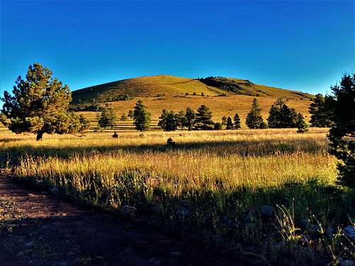 Antelope Mountain 9,003' - Apache County
Because the approach is south facing, it makes an excellent hike to do in early spring or late fall when the White Mountains to the south may have snow. The best times to hike here are March-early June and late August through late November.
Because it is relatively far from Arizona population centers, Antelope Mountain doesn’t see too many visitors.
Getting There
A dirt road leading to Antelope Mountain is located a littleover three-quarters of a mile east of the Greer Junction off of the Arizona StateRoute 260, about 10 miles west of Eager, AZ.
Once on the dirt road, there is a parking area near somestables less than a quarter mile up the road. The road itself isn’t rough.
One could drive up the road, although there are a couplegates along the way that need to be opened.
Route
From the parkingarea it is less than 2.4 miles to the summit with 800’ of elevation gain. There’s only 300’ in the first mile and ahalf at which point the road turns to the right across the south face of themountain.
It is very easy tofollow the main road to the summit. Onceat a saddle near the top, turn left and hike the last 200 yards to the summit,only gaining another 35’. There’s a pileof rocks marking the summit.
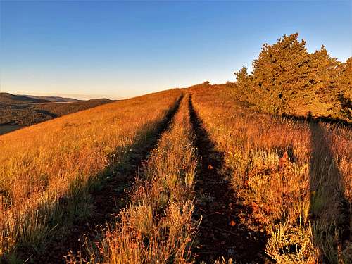 Final offshoot road to the summit and summit rocks
Red Tape
There are no restrictions to parking, however, the mountain is on Arizona State Lands, which requires a permit that can be purchased here for $15 for an individual and $20 for a family. While not typically enforced, it is a good thing to have any time exploring in Arizona since there are quite a few hiking areas on Arizona State Lands: https://land.az.gov/maps-gis
External Links
Hike Arizona page: https://hikearizona.com/decoder.php?ZTN=2187