|
|
Mountain/Rock |
|---|---|
|
|
57.09580°N / 3.61313°W |
|
|
Hiking, Mountaineering |
|
|
Spring, Summer, Fall, Winter |
|
|
3878 ft / 1182 m |
|
|
Overview
Beinn Mheadhoin
Pronounced – bane-vee-un
Summit height – 1,182m (3,883 ft)
Meaning – Middle mountain
The Cairngorm National Park was formed in 2003 to protect this unique area. It is the UK's largest national park with a large mountain range at its heart and with many diverse communities around it. The habitat offers a secure haven for many rare species and the forests include remnants of the original, ancient Caledonian pine forest. These contrast with large areas of heather moorland.
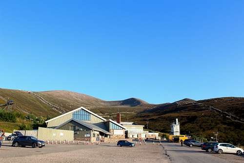
There is a well-developed ski and tourist area beneath Cairngorm mountain in the lower reaches of Coire Cas. Here, there are parking, toilet and eating facilities. In winter, it’s possible to get a bus from Aviemore to the ski area to ease the parking congestion.
The Cairngorms have been a source of enjoyment for walkers and climbers for many years. Back in 1887, the visit of a few enthusiasts to the Shelter stone crag in Glen Avon, caused the creation of the Cairngorms club.
The Shelter stone crag is actually part of Carn Etchachan but as any route to Beinn Mheadhoin from the north will pass underneath it, I feel it is appropriate to mention it here.
Named after an enormous boulder used as a bivouac site (The Shelter stone), the crag is a square shaped buttress of granite, approximately 250m high. It is an impressive sight and contains some of the best climbing routes of the Cairngorms in both Summer and Winter.
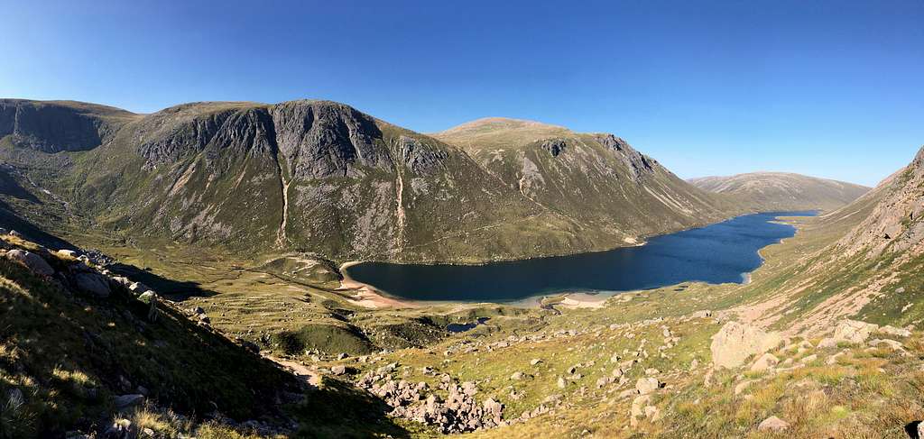
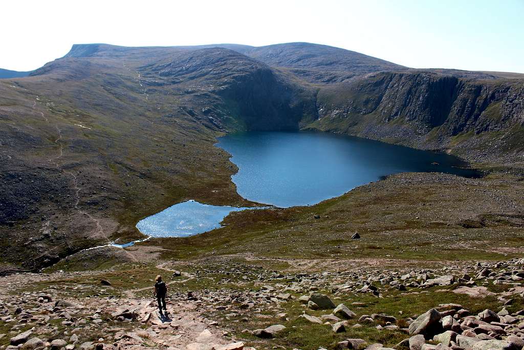
Beinn Mheadhoin lies in the very heart of the Cairngorm mountains and is one of the most remote hills in the region. This fact, along with the weather outlook, needs to be taken into consideration when any ascent is planned. It lies southeast of Cairngorm itself but these two mountains are separated by Glen Avon, a drop in height of approximately 500m to the beautiful Loch Avon.
Further south from Beinn Mheadhoin lies Derry Cairngorm and Glen Derry with the expanse of Moine Bhealaidh (Yellow Moss) a little further to the east of this glen.
Consequently, Beinn Mheadhoin cannot be seen from the roadside areas to the north (Aviemore) or from the south (Braemar). It only appears once the Cairngorm mountains themselves have been penetrated. Then, it is seen as a broad backed mountain with oddly shaped tors on the top.
The rise in popularity in recent times of “Munro – bagging” means that Beinn Mheadhoin receives a lot more attention than it otherwise might do although, it would be a fine mountain whatever its height.
Getting There
Aviemore is the main town to use as a base for the northern Cairngorms. It has many hotels and shops and provides a good bus service to the area as well as a good train service to the wider country.
By road, Aviemore is easily accessed from the main A9 road which links Glasgow with Inverness. From Aviemore a minor road runs to Loch Morlich, and from there onwards to the Cairngorm ski development at Coire Cas.
Route
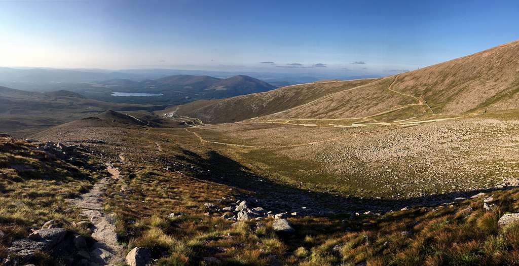
The shortest route to Beinn Mheadhoin begins in the car park at the Coire Cas ski centre, south of Aviemore and heads south again, upwards through the ski paraphernalia. A new and well-maintained path has been constructed to bring mountaineers upwards to a cairn marked on the map as being at 1141m at the top of the Fiacaill a’ Choire Chais ridge. Having climbed up around 500m, it’s now time to descend a similar amount.
Head southeast on a path following the Allt Coire Raibeirt, Beinn Mheadhoin will now be visible in front of you on the horizon – in clear weather. This mountain is remote and if conditions are deteriorating, now is the time to change your plans!
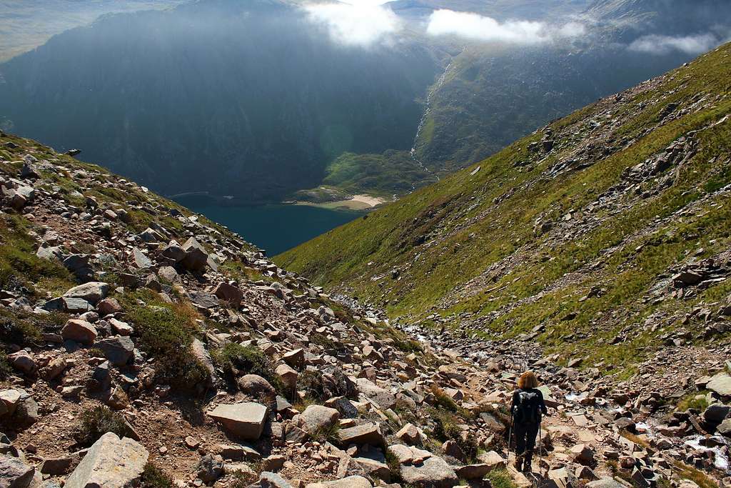
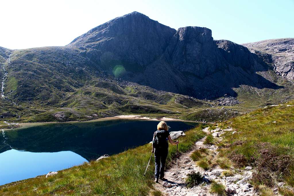
The path descends gradually at first, before following the river (Allt Coire Raibeirt) down a steep, rough path, alongside waterfalls, towards Loch Avon.
Near the loch, take a path on your right (heading west) or continue to the lochside and take a parallel path there. Both lead to a beach at the southwest end of Loch Avon.
Leave the beach and head inland towards the Shelter stone crag on one of the obvious paths to ford the river (Feith Buidhe). If there has been a lot of rain, this will be fed by many tributaries and the river may be in flood.
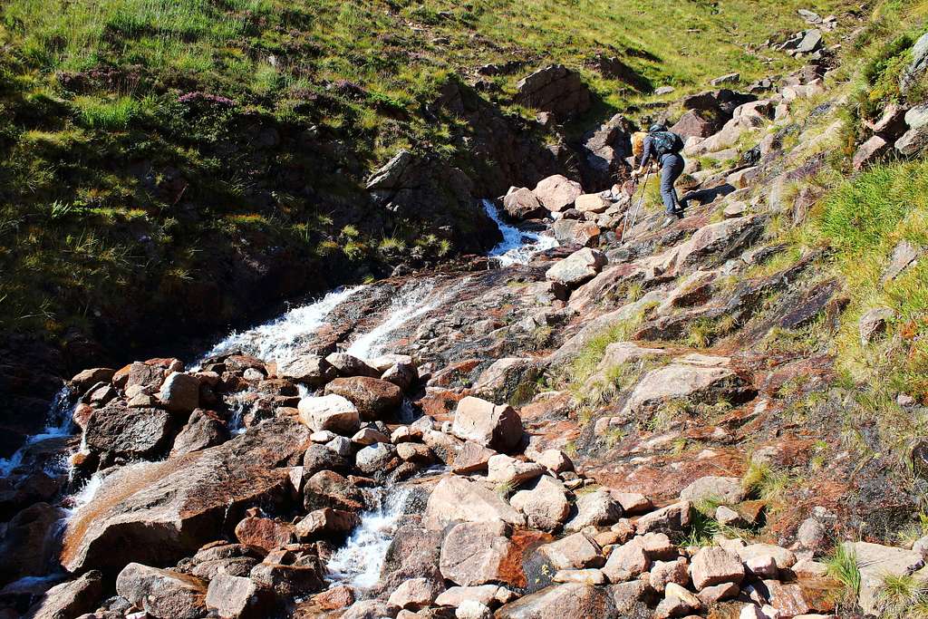
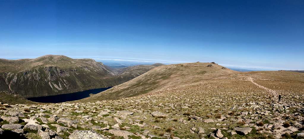
The path passes beneath the Shelter Stone crag and will bring you to a point where the next ascent begins on a path rising parallel to the Allt nan Stacan Dubha. This is steep at first but will soon lessen. There are fantastic views behind you of Loch Avon and Cairngorm and, further to the west, of the Hells Lum crag, another legendary Scottish climbing destination.
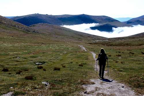
The path continues upwards in a southerly direction as the western flank of Beinn Mheadhoin is on your left. The angle of ascent becomes flatter and Loch Etchachan appears to the right of the path. Keep on going until Little Loch Etchachan is reached and the path starts to descend into the valley beyond, then turn left (northeast) uphill on another good path on the western slopes of Beinn Mheadhoin.
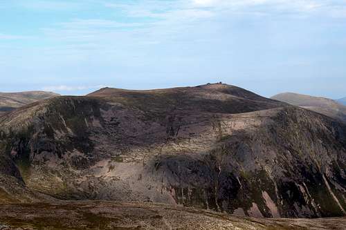
Keep going up until the summit plateau is reached, in clear weather, a pointed tor will be visible although, this is not the summit.
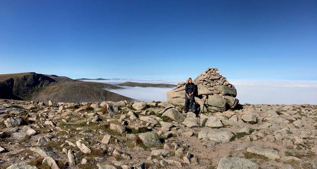
The summit area of Beinn Mheadhoin is broad and reasonably flat. This broad area is populated by a series of granite tors. Large protuberances left by retreating ice sheets at the end of the last ice age. Follow a path across the plateau. The highest point of the mountain is on the top of the northeast and largest tor.
Scramble to the top and admire the views!
Cairngorm, Ben Macdui, Derry Cairngorm, Beinn a’ Chaorainn and the summit tors of Ben Avon are all visible on a clear day
You now have to re-trace your steps down into Glen Avon, back up onto the Cairngorm plateau and down to the car park again, a very tiring but spectacular day!
This route is about 20 kilometres (12 miles) in length, with around 1,400 metres (4,600 ft) of ascent and descent required. Allow 8 – 10 hours.
There are many other ways to climb and experience this mountain and it’s possible to include it as a traverse with other Cairngorm mountains on extended trips.
Interactive map
Red Tape
No red tape.
However, Scotland has an Outdoor Access code, see link:
https://www.outdooraccess-scotland.scot/practical-guide-all
When to Climb
Spring, Summer or Autumn (Fall) depending on conditions.
Warning: The above description is for use in reasonable summer conditions. Winter conditions can occur at almost any time of the year. In winter condition, this mountain is a much more serious proposition. Any paths may be covered by snow and ice and gale force winds are common. Ice axe, Crampons, the knowledge of how to use them allied with excellent map reading and compass skills are essential.
Accomodation
Hotels and self-catering accommodation around Aviemore.
Many campsites in Aviemore, Coylumbridge and Loch Morlich but probably best to book a place in advance during high season.
It is possible to wild camp in Scotland. See the Outdoor access code for more details.
Map
OS Explorer Cairn Gorm and Aviemore No. OL57 – 1: 25,000
External Links
Walk highlands - https://www.walkhighlands.co.uk/
SMC - https://www.smc.org.uk/
Cairngorms club - https://www.cairngormclub.org.uk/
Cairngorms National Park - https://cairngorms.co.uk/