
|
|
Route |
|---|---|
|
|
35.99862°N / 75.58741°E |
|
|
Hiking |
|
|
Summer |
|
|
A few days |
|
|
Overview
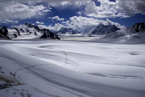
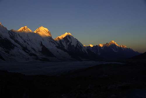
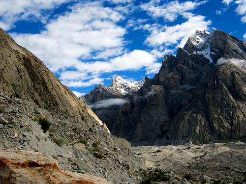
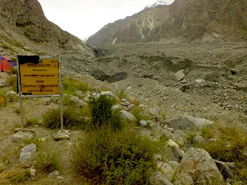
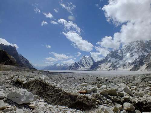
Snow Lake also called Lukpe Lawo is at a height of 4,877m above sea level in the Karakoram. It is not an actual lake but a glacial basin out of which Biafo glacier (3rd longest glacier outside the polar region) and Hispar glacier flow. It connects the ancient mountain kingdoms of Hunza and Baltistan. It is really special because of its immensity – it is 16 km long and together with the both glaciers it creates the longest glacial traverse (110 km) outside the poles. The trek consist of an easy hike of about 10-13 days depending on weather and condition of hikers. It is completely isolated with no regular communication network. No regular trail marks or signposts exist mainly due to shifting nature of the glaciers. Some campsites are marked though. Food and other resources need to be hauled. I have provided a link at the bottom to the tour guides which helped us in acquiring a guide and porters for the trek.
![SnowLake_MainShot]()
Lukpe Lawo (Snow Lake): Looking down from Hispar pass.
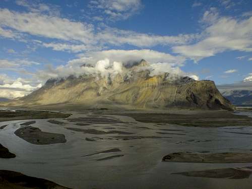
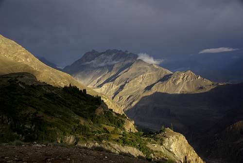
![SnowLake_Skardu]()
Mountain on which Skardu city sprawls - as seen from the road to Askole
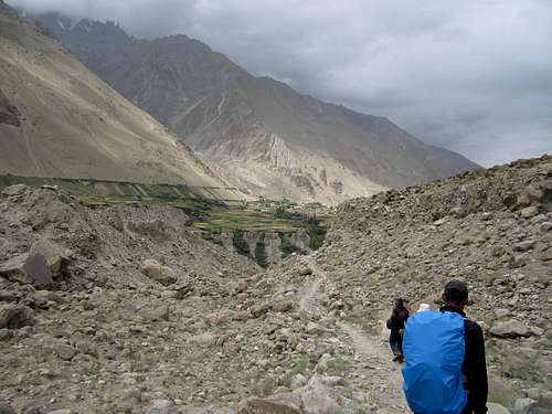
2. 6 hrs Jeep (hired) drive from Skardu to Askole village. Partly metaled partly dirt road. Depending on weather some areas might need to be crossed on foot due to landslides.
![SnowLake_LatokGroup]()
The Latok Group
![SnowLake_BianthaBrakk]()
Snow Lake: Biantha Brakk II, 6800m![SnowLake_UzummBrakk]()
Lukpe La Brakk, 6422m
![Lukpe Lawo - Snow Lake]()
Lukpe Lawo - Snow Lake
![SnowLake_BainthaBrakk_2]()
Biantha Brakk(7285m) towering above Hispar pass - Looking back from hispar glacier
![SnowLake_EnrouteGraveCamp]()
Snow Lake: Moraine along the Hispar glacier
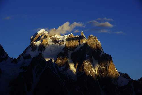
![SnowLake_GoldenPeaks]()
Golden hour for the peaks on southern edge of Hispar Glacier
![SnowLake_HisparVillage]()
Hispar Village
![Unnamed Image]()
Route Map: Green camps are the camps where we campedThe following details pertain to my own experience. I will add details where it would have been better to do things differently. More details for path is also available on picture's individual page.
![SnowLake_Kiser'sPoloGround]()
Kiser's Polo Ground (3018m)
![SnowLake_BiafoGlacierFirstLook]()
Biafo Glacier First Look - The path is along the ledge on the left
![SnowLake_NamlaCamp]()
Namla Camp (3250m)
![SnowLake_EnrouteBainthaCamp]()
Crossing Biafo to reach Biantha camp on the east side of Biafo
![SnowLake_BainthaCamp]()
Baintha Camp (3892m)
![SnowLake_MarfogoroCamp]()
Marphogoro Camp (4400m)
![SnowLake_UzummBrakk]()
Lukpe La Brakk (5400m)
![SnowLake_EnrouteKarfogoroCamp]()
Enroute Karphogoro Camp
![SnowLake_KarfogoroCamp]()
Karphogoro Camp (4500m)
![SnowLake_EnrouteToHispar]()
Enroute To Hispar
![SnowLake_EnrouteHisparPass]()
Enroute Hispar Pass
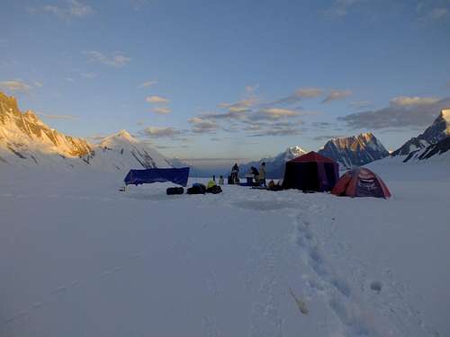
![SnowLake_HisparPassCamp]()
Snow Camp at Hispar Pass (5150m)
![SnowLake_EnrouteBakhtarBaigCamp]()
Going down the Hispar pass
![SnowLake_BakhtarBaigCamp]()
Bakhtar Baig Camp (4400m)
![SnowLake_EnrouteGraveCamp]()
Scree inside Pumri Chhish glacier
![SnowLake_EnrouteGraveCamp]()
Enroute Grave Camp (4200m)
![SnowLake_TowardsBitanMal]()
Towards Bitanmal
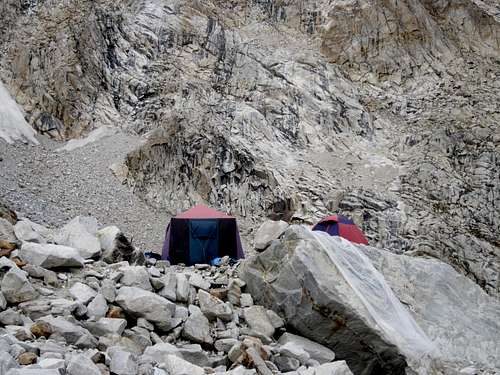
![SnowLake_BitanMalCampSite]()
Bitanmal Camp
![SnowLake_EnrouteHisparVillage]()
Enroute Hispar village
![SnowLake_EnruoteHisparVillage_2]()
Jhula on the hispar river looking towards west.
![SnowLake - RockSpires]()
![SnowLake - UnNamedPeak]()
![SnowLake - NightLongExposureShot]()
NightLongExposureShot
![SnowLake - CreviceOnBiafo]()
Crevice On Biafo
![SnowLake - WorkmanPeak]()
WorkmanPeak on Hispar pass
![SnowLake - MilkyWay]()
Milky way is easily visible in the night
Lukpe Lawo (Snow Lake): Looking down from Hispar pass.
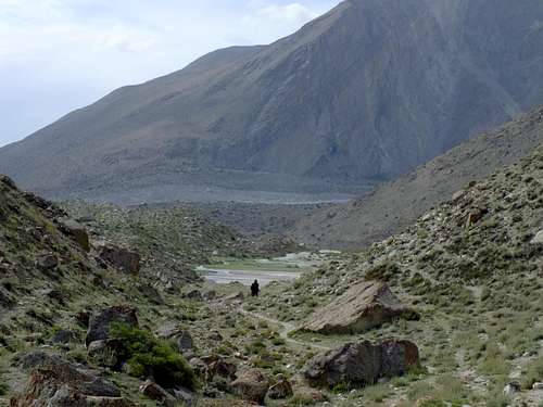
Trailhead (Askole Village): Getting There
- Reach the mountain city of Skardu in northern Pakistan.
- Daily flights from Islamabad (gets cancelled sometimes due to weather).
- Buses or hired cars drive through the Karakoram highway. Road is metaled but gets broken at places frequently due to heavy rains and landslides. It goes through these cities: Islamabad - Abbottabad - Mansehra - Bisham - Dassu - Chilas - Jaglot - Skardu
Mountain on which Skardu city sprawls - as seen from the road to Askole
![Skardu_ErouteToAskole]()
Eroute To Askole
Route Overwiew
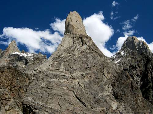
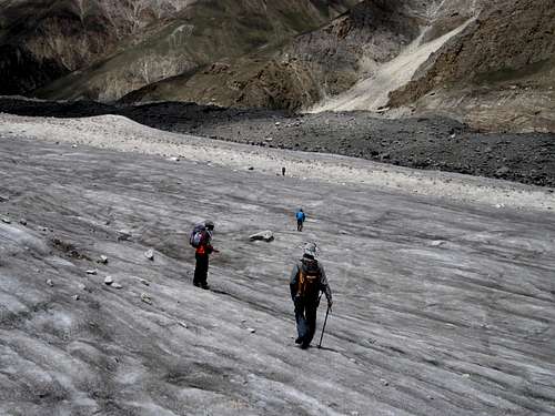
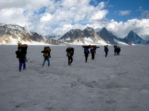
Starting at about 3000 m at Askole, the first 5 days of the trek go through the Biafo glacier (67 km long and 5 km wide). There are established campsites along the edges of the glacier, which require roughly 6-7 hours of hiking each day. The galcier is bordered by a large number of pointy Karakoram peaks, which are mostly above 6000 m high. Some of the notable peaks are the Latok group, Lukpe La Brakk, Uzunn Brakk and Baintha Brakk 1 and 2.
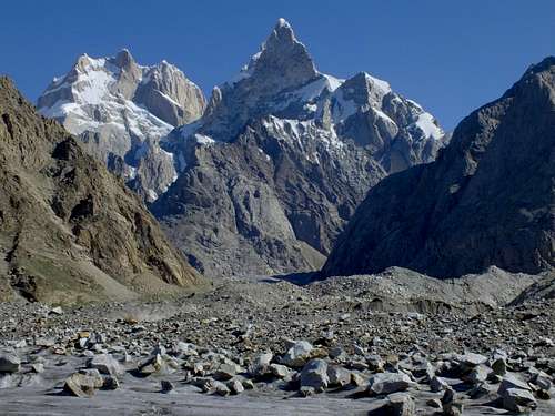
The Latok Group

Snow Lake: Biantha Brakk II, 6800m
Lukpe La Brakk, 6422m
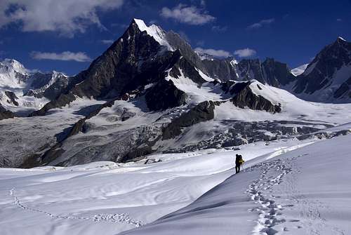
As you move up the glacier, the environment turns from lush green to sandy and later to rocky campsites. One whole day is spent crossing the width of the Biafo glacier, which is particularly interesting as you have to climb down and up again on the very unstable and steep moraine on the edges. On the 6th day we reached the edge of the Lukpe Lawo where we turned west and climbed up the Hispar pass (5150m) and spent the night there. There one can really appreciate the gigantic expanse of snow and ice.
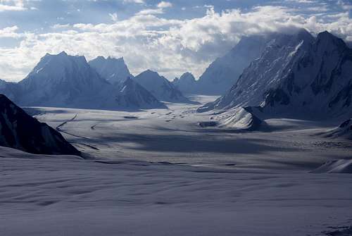
Lukpe Lawo - Snow Lake
While the Biafo is mostly a smooth ice highway, the Hispar glacier is a mess of churned and twisted ice as 5 different glaciers flow into it on its northern side at a remarkable pace making it impossible to walk on the glacier. There is no track on the southern edge as it is lined with snow covered avalanche prone 7800m peaks. The trek goes through the campsites on the north edge and crosses the flowing in glaciers along the way, which is particularly taxing because of strenuous boulder hopping and steep hillside lateral moraines. It takes some 4-6 days to get to the Hispar village, where you can get a Jeep to Karimabad, Hunza and back to civilization.
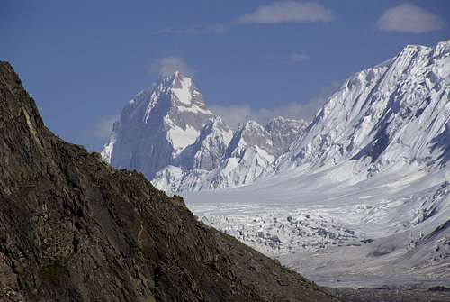
Biantha Brakk(7285m) towering above Hispar pass - Looking back from hispar glacier
Snow Lake: Moraine along the Hispar glacier
Golden hour for the peaks on southern edge of Hispar Glacier
Hispar Village
Route Details
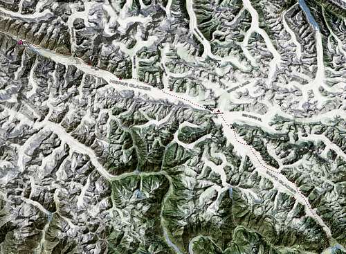
Route Map: Green camps are the camps where we camped
Kiser's Polo Ground (3018m)
Day 1: We Drove to Askole from Skardu(6 hrs) . Here the guide divided the loads to porters. Final checks about equipment and food were made here. Then 2-3 hrs trek to the Kiser's polo ground(3018m) right infront of Bakhor Das peak (5809m) which is the first camp site. (Water needs to be fetched from a stream falling into Braldu some way before.)
Biafo Glacier First Look - The path is along the ledge on the left
Namla Camp (3250m)
Day 2: We Started early. After about 1 hour we climbed a small pass on the left to reach the western moraine of Biafo glacier. Some good balance was required on this moraine. 3-4 hrs hike to Namla camp(3250m) on the western edge. Its small meadow with enough space for 8-10 tents. (Water needs to be fetched from streams in Biafo glaicer some way down.)
Crossing Biafo to reach Biantha camp on the east side of Biafo

Baintha Camp (3892m)
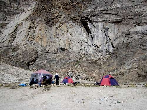
Day 3: We started early and got down to the glacier. Walked mostly in the smooth middle part of the glacier. After two hours we could see the green campsite of Mango on the left but we skipped it and crossed the glacier to get to the other side of the glacier. The lateral moraine on this side needs some balance. After we were clear of the glacier we reached a campsite called Shafung. We skipped it too and continued for two more hours to reach Biantha campsite(3892m) overlooked by the Biantha Brakk (7285m). We hiked a total of 9 hrs(about 20km) but earned a rest day which we spent bathing in the Biantha lake and washing clothes. It is also ok to stop at Shafung and do the short hike to Biantha the next day. Mango is not suitable as you will need to negotiate with moraine 2 time more than necessary. (Water is readily available from a stream coming from Biantha lake.)
Marphogoro Camp (4400m)
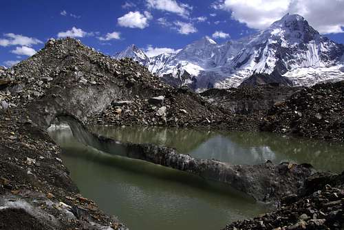
Lukpe La Brakk (5400m)
Day 4: We got down to the glacier and in about four hours reached the next sandy camp site called Marphogoro(4400m). We crossed Latok and Biantha groups on the right. This camp dominated by the rock spire of Lukpe La Brakk(5400m). (Water is not available in the camp site and can be fetched from Biafo glacier.)
Enroute Karphogoro Camp
Karphogoro Camp (4500m)
Day 5: Again a short day and easy. We hiked for about 3-4 hours and reached the rock camp site of Karfogoro(4500m). It was a very small space with space enough for about 4-5 tents. (Water is not available in the camp site and needs to be carried from Biafo glacier.)
Enroute To Hispar
Enroute Hispar Pass
Snow Camp at Hispar Pass (5150m)
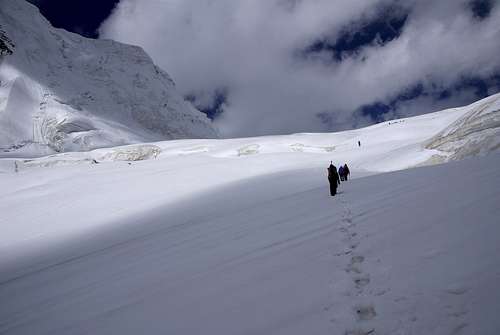
Day 6: We started really early, almost in the dark as it was prudent to cross the part of snow lake before the snow starts to melt in the sun. We roped up this day for security from fresh snow covered crevices. In about 1 hour we turned west and started hiking up the hispar pass and in 3-4 hours reached the top(5151m). Its a wide pass where tents can be pitched very easily. Decision to camp here depends solely on weather. We had a good spell of weather going on so we camped there. Looking back towards east we got the iconic panorama of Snow Lake with the Ogre dominating the landscape. (Water needs to be melted from snow.)
Going down the Hispar pass

Bakhtar Baig Camp (4400m)
Day 7: We started early for the same reason as Day 6 as we have to climb down the pass. We reached at the base of pass in about 3 hours. Two more hours of walking on the Hispar glacier and we reached the Bakhtar baig camp(4400m) on the northern edge of glacier. If some finds it necessary to not stop at the pass he can stop at the Khani Basa camp which is directly beside the base of the pass. (Water is readily available from a small river nearby.)
Scree inside Pumri Chhish glacier

Enroute Grave Camp (4200m)
Day 8: We started early and crossed two side glaciers that flow in to Hispar glaicer. These were Yutmaru and Pumri Chhish. Pumri Chhish is littered with boulders, torn up ice blocks and loose scree. We had to back track a couple of times. It tooks us about 2 hours. This day we hiked for about 13 hours. It is advised to camp before Pumri Chhish if you are tired and not enough time is left in daylight. We camped on unnamed camp (4200m) marked by the grave of a porter from long ago. (A small stream of water is nearby.)
Towards Bitanmal
Bitanmal Camp
Day 9: Because of hard trek the day before we had an easy day today. Bitanmal is about 3-4 hours, just before Kunyang glacier. It is a big meadow with easy access to water from a stream through the meadow.
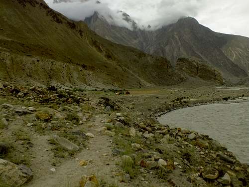
Enroute Hispar village
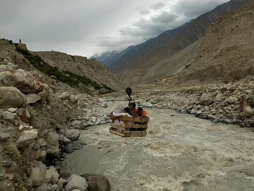
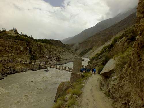
Jhula on the hispar river looking towards west.
Day 10: We crossed Kunyang glacier and hike towards the Hispar village. It was about 3-4 hours to the village ending with crossing the Hispar river on a Jhula to reach the village on the southern edge of the river. Jeeps can be arranged here to reach Nagar valley.
Motivational Pcitures
People have said that no other place on Earth gives a finer mountain scenery than Snow Lake. This is why.
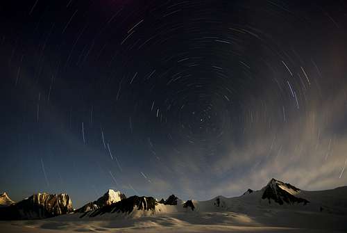
NightLongExposureShot
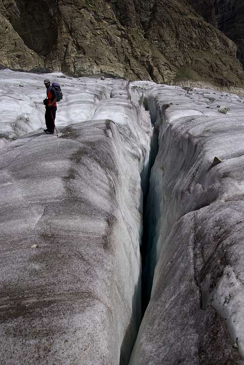
Crevice On Biafo
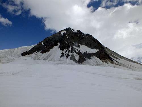
WorkmanPeak on Hispar pass
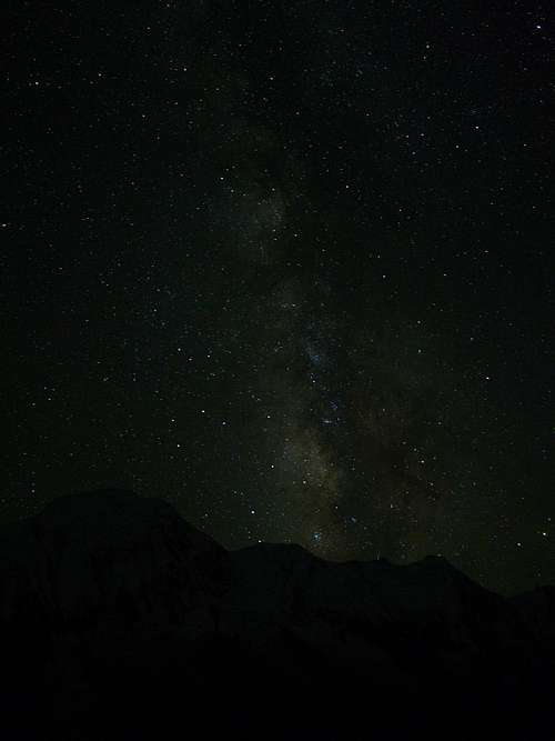
Milky way is easily visible in the night
For Expedition Planners
Here I am giving some tips on planning an expedition for this trek:1. Hire a proper guide: It would be necessary if you are novice to expedition style trekking and have only done alpine style hikes.
2. If you have been a couple of times to the Himalayas or the Karakoram already then it can be attempted although it would mean you would need to be more careful, carry more luggage (mostly food for 10-12 days). You will need to do the logistics (like hiring porters and Jeeps etc.), which is not easy for someone who is not familiar with the culture and the language.
3. Be ready to feel effects on altitude especially if you have never been above 4000m. These are excessive fatigue and going out of breath too soon. These are normal and your body can adjust to the altitude with some rest.
In the end I will give the link to the tour operator who performed the logistics (guide -porters - jeeps - food - cooking utensils - tents - Kitchen tent with cook) for us. I am not advertising on their behalf but only trying to help anyone who is curious enough to plan a holiday in Karakoram. They are a tour operator registered with the tourism department based in Skardu.