
|
|
Mountain/Rock |
|---|---|
|
|
36.91420°N / 82.8939°W |
|
|
Harlan |
|
|
4139 ft / 1262 m |
|
|
Overview
Situated within a couple hours of Mt. Rogers, Smoky Mountain National Park, and Mount Mitchell, is the highest point of Kentucky - Black Mountain.
Most of Kentucky does not reach high elevation, and the state is known much more for its caves than its mountains. Black Mountain is actually quite large, but underappreciated for its status as the highest mountain in Kentucky. So much so that coal mining was done for years on the upper reaches of the mountain, and a huge high voltage tower charges within 1/10 of a mile of its summit. A waiver used to be required to hike Black Mountain; to be signed and have on your person in case you ran into employees of the coal company. That has since changed.
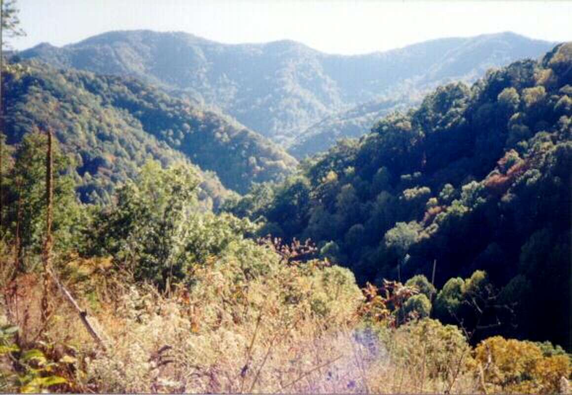
The summit itself is reached via an offshoot from a long and winding mountain road. The mountain is flanked by steep drop offs and rock walls. Since the area has been used for coal mining, the road (route 160) crosses some of the best scenery in the state, without so much as an overlook to take it all in. An overlook was built on the Virginia side in recent years, which will hopefully give visitors a good view of the mountain.
In 2018, the State took ownership of the high point and improvements have been made; and those improvements will make the experience more enjoyable in years to come. However, as of the summer of 2020, it is my understanding that the lookout tower is still not climbable, and a new one is still planned, so there aren't really any views from the summit.
 |
 |
 |
 |
 |
Getting There
Black Mountain is on the border between Kentucky and Virginia. It can easily be found via a standard road atlas, but the closest interstate is I-81. From the interstate, it can be approached from a variety of roads between Bristol, Tennessee and Marion, Virginia. Getting there isn't too difficult. Black Mountain is listed on most road-maps. The key is to get to Route 160, near Lynch, Kentucky. Route 160 is a winding mountain road that is fun to drive. In fact, it is a far prettier drive than it is a hike. The road to the top is actually easy to find because it sits directly in between the "Welcome to Virginia" and "Welcome to Kentucky" signs. Coming from Virginia, the road is on the left, and you can park at the base. When I visited in 2002, it was unmarked, but once on the road it is easy to find. To ensure it is the correct road, check to see if it goes up! There is a tower at the summit, so it is easy to find.
For most of the year you can take the road and drive near the summit, but in the winter, the road gets icy and it is better to walk the 1.5 miles, and 250' to the summit.
 |
 |
 |
 |
Red Tape
A waiver used to be required to hike to the Black Mountain summit. However, with State ownership, this is no longer the case.
When To Climb
It is far better to hike here in the winter, because less work is being done up at the summit. The scenery is better in December/January as the ice forms on the rock walls.
Camping
Prime Hiking and Camping is available at Kingdom Come State Park several miles away from the highpoint.
Kingdom Come State Park
Redwic - May 27, 2009 2:29 am - Voted 10/10
The Summit Road...The road leading to the summit has a sign on the rightside of the entrance. It says "FAA En Route Radar Lynch, KY". Also, the summit road is the PAVED road, not the dirt road next to it.
Redwic - May 27, 2009 2:34 am - Voted 10/10
The USGS Benchmark...The USGS Benchmark disk for Black Mountain is found on a large boulder, just beyond a small path/opening in thick brush located on the east side of the summit area.
taggaj00 - Oct 28, 2013 10:09 pm - Hasn't voted
No Sign at Summit Road !I observed no sign at the entrance to the Summit Road from Rte. 160 coming from Kentucky side, on a recent visit. But a turn to the right, just before the 'Welcome to Virginia' sign, leads to the Summit Road (uphill). The handsome plaque, marking the summit height (4,139 ft.) and honoring local World War II Veteran, and Cable TV pioneer William Risen, was erected on a pedestal by 'Hands Across the Mountains'. Directly beyond the plaque, the USGS Survey Marker lies on a prominent boulder in a small copse of trees. It was a foggy, early Fall evening with wildflowers in profusion; not a bad day in the beautiful Southern Appalachians.
ticktock5051 - Jul 19, 2015 1:00 pm - Hasn't voted
Trip infoI did this point last week. Here's some updates: -The summit road is no longer "paved." Although remnants of pavement remain, the drive up is mostly dirt -There is no sign for the summit road. However, the summit road is the road to the LEFT of the FAA Long Range Radar sign -There is a large pullout right next to the "Welcome to Kentucky" sign. I slept in my car there the night before and this provides an alternative to camping miles away. -Most importantly: Under NO circumstances attempt to go to the next town over (Lynch/Cumberland) by taking a "scenic adventure" using the other dirt roads in the area. I decided to do so and - going down Cloverlick Creek road from Black Mountain - encountered some SERIOUS grades and terrain. Since I was departing the highest point in the state, I could descend alright, but if I had to go up a similar road, I would seriously be at risk of having to abandon the car. If you're going to do a dirt road adventure, make SURE that you have a passable route and do prior research. Don't get into the situation I did
DaveFromAtlanta - Oct 15, 2018 4:30 pm - Hasn't voted
Did this today October 15, 2018A few people have asked about the road. It's 1.6 miles from Hwy 160. It's the only side road between the Virginia and Kentucky state line signs. There are a few short stretches of pavement, a few chucks of pavement and mostly dirt and rocks. Keep your speed down and you should be fine. When you get to the fenced FAA facility, you might think about walking the rest of the way. The last little stretch of road is a bit rough. The marker itself, is on the rock just behind the historic marker.
vanman798 - Aug 14, 2020 1:06 pm - Hasn't voted
Wavier no longer neededOn the 50 States Highpoint Facebook page, Admin Stony Burk four days ago (August 10, 2020) let the group no that a waiver, as mention on this SP page, is no longer needed to access this highpoint. He wrote the following, "Just an FYI for those heading to Black Mtn. The state now owns the summit and does not require a waiver. Back in the 90's when the interest in highpointing was really taking off an agreement was made by the Highpointers Club and Penn Coal, who was actively mining the area, that club members who wanted to visit the summit needed to sign a waiver accepting personal responsibility for their safety. It was believed at the time that underground mining near the summit could cause a cave in. Waivers were made available at the Coal Mining Museum in nearby Benham, in the club newsletter and online. The waivers were to be mailed to the coal company and most club members would also carry a copy with them to the summit. I've been going up there since 1992 and used to see mining activity all the time in those early days and usually talked with a few miners when I could. Eventually operations stopped and I noticed locals were going up there quite a bit. Some were just helping with clean up and mowing around the summit or simply hanging out. None had waivers. We are working with the folks in Cumberland County and hope to assist in improving the road at some point. There are also plans to build an observation tower to replace the one up there now. If you have the time visit the museum and take a tour the mine. They're worthwhile. Let me know what sites you are using that still mention needing a waiver and we'll work to correct it."
hgrapid - Aug 14, 2020 1:55 pm - Hasn't voted
Re: Wavier no longer neededThanks. I'll look into it and make the change.