
Comments
No comments posted yet.
|
|
Trip Report |
|---|---|
|
|
49.78940°N / 125.83048°W |
|
|
Sep 6, 2021 |
My friend Allen and I decided to climb Elkhorn Mountain, along with King’s Peak, after our first three choices for IQ climbs proved unworkable. Say what you like about Elkhorn: at least it isn’t shut away like the Lady of Shallot behind the employees-only gates of the Mosaic logging company (Mount Harmston), or reachable only via the unforgiving cross-ditched roads of the Western Forest Products logging company (Victoria and Warden Peaks). In fact, you can climb King’s Peak and Elkhorn Mountain without the slightest regard for the whims of any logging company, and you can get there in an ancient VW Golf, if that is your fancy.
As was my fancy, I drove us to the King’s Peak trailhead in my ancient VW Golf – there was a short dirt access road from the highway, but the car had no problems on it, which suggests that no car in the world would have problems on it. We arrived at the crack of 4pm in a drizzle. Two young guys started up the trail from the parking lot before us – they said they were planning to summit King’s Peak the following day, stopping for the night at the lower meadows. This was distressing news. Philip Stone, in Island Alpine, recommends his readers avoid the meadows for “hygienic” reasons, and instead continue to Queen’s Ridge. We didn’t have the heart to tell the lads that Philip thought their camping plans were gross.
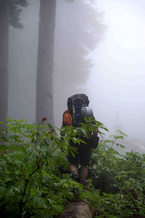
We hiked the trail in showery twilight. Presumably we were surrounded by beautiful scenery.
A couple of hours in, we saw tents looming out of the mist and realized we had arrived at Camp Cholera. From my backpack, the photocopies of Island Alpine screamed at us to keep going. We kept going. Above that foul plain, the trail becomes more of a hands-on scramble. Eventually we reached a flattish area with a stream running through it which I can only assume was the upper meadows. There was no one camping there, and it probably would have been a good place to set up shop, but we weren’t about to gainsay Philip now. After filling our bottles, we scrambled up a steep gulley, getting good and soaked from the wet foliage. At 8pm, we reached the ridge.
If most of the trail up to this point had been theoretically picturesque, with the mist hiding lush foliage and waterfalls, the Queen’s Ridge was theoretically absolutely spectacular, with soaring vistas on three sides and the mountain at its back, all utterly obscured by clouds. Still! Queen’s Ridge! We set up camp, only slightly perturbed by the complete lack of drinking water anywhere. Neither of us was relishing a trip back down the gulley to collect more the following day. “Likely this problem will simply solve itself somehow!” we assured each other.
The problem solved itself! To our rescue came that faithful hiker’s friend: savage unrelenting rain. It poured all day. The dry tarn beds filled back up, as did the pot I put out to catch the tent drip. We decided to stay put.
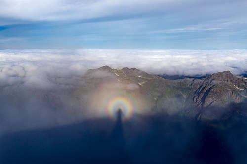
Feel free to print out this picture and colour in your own beautiful backdrop in place of the shapeless mist!
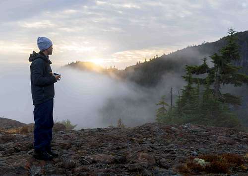
The day dawned gloriously. At breakfast, for the first time, we caught glimpses of things that weren’t variations of clouds. Anything seemed possible.
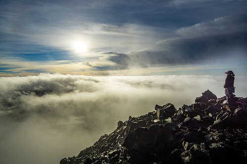
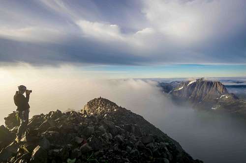
Allen peers into a landscape that's only like two thirds clouds, tops.
Up the glorious alpine trail to King’s Peak. From its shoulder, we saw Elkhorn “the Matterhorn of Strathcona”, for the first time. It was every bit as triangular as we’d hoped.
A pleasant walk over bare rock took us to the summit, where we signed the logbook – we were the first to do so in five days. It was a sobering moment. The Parking Lot Lads, no doubt, were doubled over with dysentery in Bacteria Meadows. There but for Philip Stone.
The summit also gave us a good view of our two options for reaching the west side of Elkhorn, which was where we planned to camp before making our push to the top.
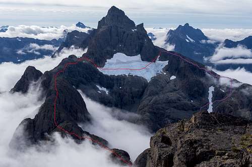
The first, roughly marked in red, ran along the King’s-Elkhorn Traverse, then over the glacier and up to the Northwest Ridge. The second, the last stage of which is roughly marked in purple, went down into the cirque below Elkhorn’s north face, then back up onto the Northwest Ridge, crossing a small snowfield.
The red route was the one we’d been originally planning to do, and it offered many advantages: an exciting ridgeline, a glacier crossing, and the enticing prospect of not descending 600m and then immediately walking back up again. But there was one problem: we could not, from that vantage point, see the eastern side of the glacier. So we couldn’t say for sure whether there was a safe way down. The purple route, less glamorous at every turn, was at least fully visible at all key points.
Philip had a heavy thumb on the scale, awarding the red route two stars and not even deigning to give the purple route a rating. But by this point, some of the halo had gone from our absent guru. True, he had saved us from the Fate of the Parking Lot Lads on the Typhoid Plateau. But hadn’t he also come near to killing us with thirst on Queen’s Ridge? We decided to take the cirque.
There are no trail markers from King’s Peak down into the cirque, but we followed Philip’s description, and, after one false start, found our way southward along the scree slopes on the side of the ridge, angling slightly downwards as we went. We arrived at the “huge overhanging basalt dome” Philip had promised us – I don’t mean to be cruel, but this is one ugly piece of rock. Completely out of scale and of place. If you were painting the ridgeline, you'd have to leave it out because it would ruin your composition entirely. You’ll note I haven’t included a photo of it out of decency. However, it was at least a useful indication that it was time to begin our descent. We executed a crisp 90-degree turn to our right and started down a steep scree gulley.
After going some ways down, we thought we’d try and outsmart the scree by cutting to our left, through an inviting grove of true firs. Needless to say, we failed. You can’t outsmart scree. Upon reaching impassable cliffs, we ignobly retraced our steps to the gulley through the now distinctly uninviting firs. I’ll admit that at this point, we had many choice words for our silent hiking companion, False Prophet Phil, who had promised us “a lower angle traverse line that can be used” and a descent to 1500m, rather than the 1440m at the bottom of the gulley, which seemed to necessitate a turn to the left. But with sober screeless hindsight, I can say that the fault lay not in our guide, but in ourselves. We had simply missed the traverse line, wherever it was.
The cirque was a pleasant surprise. It is staggeringly beautiful, with bounding streams and waterfalls surrounded by alpine shrubs, under the brooding watch of two mountains and a shrunken (compared to photographs) but still-impressive glacier. I doubt many people camp here – I imagine most, like us, pass through on their way to set up on one ridge line or another. But it would be an excellent spot. We had lunch by the babblingest god damn brook I’d ever seen, and the dancing water looked so fresh and merry that I added it untreated to the powdered hummus I’d made – a shocking breach of protocol, but one which, to date, has had no ill effects.
Me in the cirque, in a rare (and unrepresentative) non-scree moment. Photo credit Allen.
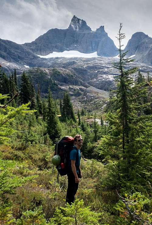
The next step was the long trudge up the side of the northwest ridge – mostly on scree, with some scrambling over basalt outcroppings. We reached the tongue of snow (near the right side of the photo above), and opted to cross over to a scree gulley on the other side rather than ascending up the snow itself. After a scramble, we gained the ridge. Again, completely stunning. The last phase of our hike that day was a kingly promenade with Olympian views on both sides. But the best was still to come. When we reached the shoulder of Elkhorn Mountain, we saw that some saint – some absolute rocksmith saint – had built a sheltered campsite out of mighty boulders on the ridge. The workmanship was perfect and the view was unbeatable. This photo does not do it justice. Madam or sir, whoever you are: the works of your hand are mighty indeed.
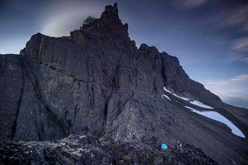
There was no water to be had here, but luckily there was the large snowfield you can see in the photo. Since we were there around the snow nadir of early September, following BC’s hottest summer on record, it’s probably a safe bet that you’ll have snow whenever you visit, assuming of course that everyone meets or exceeds their Paris emissions targets! The melted snow rehydrated this recipe from thrueat.com which I made for the first time on this trip and which I’ll pause to note is hands-down the best backpacking food I’ve ever had: https://www.thrueat.com/backpacking-recipes/chicken-thai-curry.
From our campsite, we finally had a clear view of the eastern side of the glacier, and it looked as though we probably could have made it across. Oh well.
We woke up at 5:45am to start our climb up the West Couloir. This ended up being easier than I thought. The route was fairly intuitive, and, with some helpful advice from Phil, we didn’t make any wrong turns – though I imagine it would be trickier navigation work for people descending the West Couloir after ascending by a different route. Perhaps foolishly, we didn’t rope up at any point going up (though we belayed on the way down in a couple of places). The view from the top was magnificent, especially for die-hard cloud aficionados like us. We spent quite a long time on the summit, waiting for the wind to reveal some vistas, and every so often we were rewarded:
Allen photographs a different summit (Mount Colonel Foster) even though he's already standing on top of a perfectly good summit (Mount Elkhorn). Why can't you be content with what you have, Allen? Desire is the route of all suffering.
I’m now going to skip ahead to the thing that motivated me to write this report in the first place, which was the descent to the Elk River. Once we were back down from the summit, eating breakfast at our beautifully-rocksmithed camp, we both had the impression that the challenge of the trip was behind us, and that what remained was a tranquil dénouement. How young we were, and how foolish. The next section was, on balance, the hardest portion of the entire route. The first part of the descent was fine – down to what both Philip and the Hiking Trails 3 people poetically term – in a conscious or unconscious tribute to JFK – “the forested col”. Maybe a bit more adventurous than I was expecting, but nothing too outlandish. The highlight was probably getting the stink eye from this grouse:
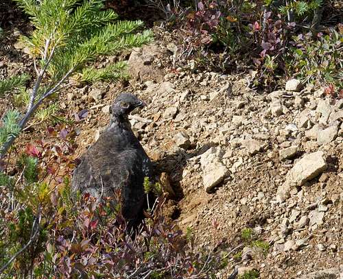
This grouse could see we were complete trash.
But below the forested col: there lies madness. The path almost always goes straight down the face of the slope, laughing switchbacks to scorn. The trees delight in growing small, slippery roots perfectly aligned with the direction of the trail: you step on them without seeing them and you go flying and the trees think it’s funny.
The part I really want to tell you about, though, is one particular section where you descend down the gulley of a stream, over a flat, sloping rock face, while holding onto a rope (assuming the rope is still there). That in itself is not such a problem (again assuming the rope is still there), but the thing you need to know is that when you get to the bottom of the rope, you do not continue down the gulley! Instead, cast thine eyes to the left, up the riverbank, where there is a tree coyly decorated with the amount of ribbon you might use to wrap a present if the present in question was a cornflake. There are covert KGB drop sites that announce themselves with more fanfare than this dramatic bend in the trail. Not being possessed of this kind of microscopic eye for detail, and not having come up this way, we of course blithely missed this marker and instead continued down the gulley until sheer hardship convinced us that we could not possibly still be on the path of righteousness and that we had badly blundered.
There’s a beautiful moment left ahead: when you reach the Elk River, cross over on a steady log, and step onto the groomed, graded ERT. It’s like that most luxurious of sensations: the feeling of stepping onto the moving sidewalk at the airport, when there are no slow walkers in front of you. All was well. An excellent trip.
Nick Melling