
-
 2863 Hits
-
 0% Score
-
 0 Votes
|
|
Custom Object |
|---|---|
|
|
fntest |
Photos in tables

|

|

|
|---|---|---|

|

|

|

|

|

|
Original Size

|
|---|
Text in box
|
The “Ceded Strip”. The park was established in 1910. |
Landscape

|
|---|
Side by Side
 |  |
|---|
no borders

|
|---|
Photos in tables
 |
 Mountain Douglasia Mountain Douglasia |
 Alpine Forget-Me-Not Alpine Forget-Me-Not |
 Arrowleaf Balsamroot Arrowleaf Balsamroot |
 Rocky Mountain Phlox Rocky Mountain Phlox |
 Tapered Leaved Beardtongue Tapered Leaved Beardtongue |
Headers
25%, size = 1
50%, size = 2
75%, size = 4
100%, size = 6Frequently used text and links
Place Names of Glacier National Park by Jack Holterman
A Climber’s Guide to Glacier National Park; J. Gordon Edwards
CLIMB REGISTRATION: You do not have to register for day climbs in Glacier National Park but it is recommended. Backcountry travel regulations can be found at Backcountry Travel. There is also information from the Park Service on Mountain Climbing in Glacier. Registration for climbing Mount Gould can be accomplished at the Logan Pass Visitor’s Center.
As with all hiking and climbing in Glacier National Park use caution and practice good manners with the wildlife. You are in bear country. Carry bear deterrent spray, don’t hike alone and make some noise. For more information please go to the Park's website for Bear Information. The U.S. Forest Service also has helpful information on Grizzly Bear Management.
Vehicle single entry fee for Glacier National Park is $25.00 for 7 Days, $12.00 per person for single hiker, motor biker or bicyclist. An "America The Beautiful Federal Lands Recreational Pass" for goes for $80.00 which gives entrance to all National Parks, National Forests, BLM, US Fish & Wildlife, and Bureau of Reclamation sites for one year from date of purchase. See Plan Your Visit for other information regarding all of the National Park entrance fee information.
If you are planning on visiting Waterton Park make sure you have a passport to simplify crossing the border.
Glacier National Park’s Lincoln Peak is located in Northwest Montana. The locals all say, "Have a nice VISIT in Montana". While you are visiting check out other things to do at Things To Do In The Flathead Valley.
Montana is a long way from most places. That’s why many of us live here.
It is possible to get here by:
By Air: Glacier International Airport serves as the air hub for northwestern Montana. Horizon, Delta Connection and Northwest Airlines service this area.
By Bus: Northwest Montana is served by bus service.
By Rail: Amtrak arrives daily from Minneapolis or Seattle stops in East Glacier, Essex, West Glacier and Whitefish.
By Road: The major highways serving northwest Montana include U.S. Highway 2 running east and west and
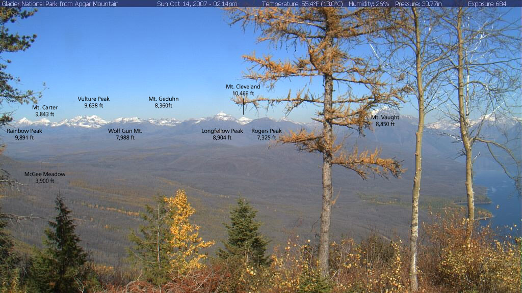
Apgar Cam with Peaks Identified
Apgar Webcam Page
Glacier National Park in Pictures
Glacier Mountaineering Society
Logan Pass Trails
Visit Montana running north to south are U. S. Highway 93 and Montana Highway 83. Glacier National Park is located 160 miles north of Interstate 90 which runs through the southwestern portion of Montana.
Rental cars can be secured in the Flathead Valley at and near Glacier International Airport. See Car Rentals in Montana.
In Montana it is said “If you don't like the weather just wait a half hour” or you can check out what’s up with the local weather at Glacier Park Weather.
Click on the Linked Text to View More Photos of the Route
Special Considerations: The rock in Glacier Park is widely varied and it is not unusual to find several different types of rock on any given route. Know your rocks and be certain of your safety. J. Gordon Edwards has an excellent section in his guidebook on rock and climbing safety. Be safe and know your limitations as well as those who are climbing with you. Also refer to the following links for further details: GNP Rock and Grading System and the GMS Climbing Guidelines.Image embedded in text
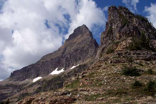
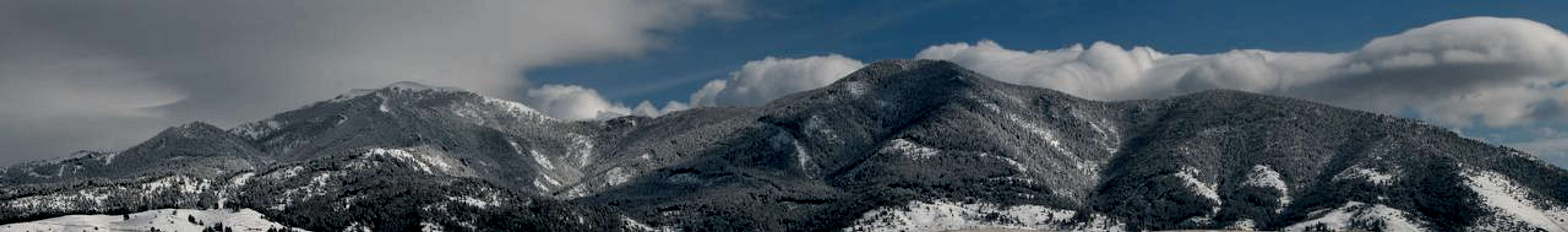
 The Apgar Range runs northwest from near the West Entrance of Glacier National Park near West Glacier, Montana. It is near the southern end that Apgar Lookout is found. The northern terminus is located at the Camas Creek Entrance Station below Huckleberry Mountain.
 The Apgar Range runs northwest from near the West Entrance of Glacier National Park near West Glacier, Montana. It is near the southern end that Apgar Lookout is found. The northern terminus is located at the Camas Creek Entrance Station below Huckleberry Mountain.
 The Apgar Range runs northwest from near the West Entrance of Glacier National Park near West Glacier, Montana. It is near the southern end that Apgar Lookout is found. The northern terminus is located at the Camas Creek Entrance Station below Huckleberry Mountain.
Sizing images
Space
frosty
Perhaps Robert Frost wrote it best in his poem, The Road Not Taken:
‘Two roads diverged in a yellow wood, And sorry I could not travel both …………………… I took the one less traveled by, And that has made all the difference.’
Triple Photos
Climbing Going-to-the-Sun Mountain


video
Here's a video of Rock Lake by Alpendave:
Rock Lake.MOV
test 3
75%, size = 4
100%, size = 6Frequently used text and links
Place Names of Glacier National Park by Jack Holterman
A Climber’s Guide to Glacier National Park; J. Gordon Edwards
CLIMB REGISTRATION: You do not have to register for day climbs in Glacier National Park but it is recommended. Backcountry travel regulations can be found at Backcountry Travel. There is also information from the Park Service on Mountain Climbing in Glacier. Registration for climbing Mount Gould can be accomplished at the Logan Pass Visitor’s Center.
As with all hiking and climbing in Glacier National Park use caution and practice good manners with the wildlife. You are in bear country. Carry bear deterrent spray, don’t hike alone and make some noise. For more information please go to the Park's website for Bear Information. The U.S. Forest Service also has helpful information on Grizzly Bear Management.
Vehicle single entry fee for Glacier National Park is $25.00 for 7 Days, $12.00 per person for single hiker, motor biker or bicyclist. An "America The Beautiful Federal Lands Recreational Pass" for goes for $80.00 which gives entrance to all National Parks, National Forests, BLM, US Fish & Wildlife, and Bureau of Reclamation sites for one year from date of purchase. See Plan Your Visit for other information regarding all of the National Park entrance fee information.
If you are planning on visiting Waterton Park make sure you have a passport to simplify crossing the border.
Glacier National Park’s Lincoln Peak is located in Northwest Montana. The locals all say, "Have a nice VISIT in Montana". While you are visiting check out other things to do at Things To Do In The Flathead Valley.
Montana is a long way from most places. That’s why many of us live here.
It is possible to get here by:
By Air: Glacier International Airport serves as the air hub for northwestern Montana. Horizon, Delta Connection and Northwest Airlines service this area.
By Bus: Northwest Montana is served by bus service.
By Rail: Amtrak arrives daily from Minneapolis or Seattle stops in East Glacier, Essex, West Glacier and Whitefish.
By Road: The major highways serving northwest Montana include U.S. Highway 2 running east and west and
Apgar Cam with Peaks Identified
Apgar Webcam Page
Glacier National Park in Pictures
Glacier Mountaineering Society
Logan Pass Trails
Visit Montana running north to south are U. S. Highway 93 and Montana Highway 83. Glacier National Park is located 160 miles north of Interstate 90 which runs through the southwestern portion of Montana.
Rental cars can be secured in the Flathead Valley at and near Glacier International Airport. See Car Rentals in Montana.
In Montana it is said “If you don't like the weather just wait a half hour” or you can check out what’s up with the local weather at Glacier Park Weather.
Click on the Linked Text to View More Photos of the Route
Special Considerations: The rock in Glacier Park is widely varied and it is not unusual to find several different types of rock on any given route. Know your rocks and be certain of your safety. J. Gordon Edwards has an excellent section in his guidebook on rock and climbing safety. Be safe and know your limitations as well as those who are climbing with you. Also refer to the following links for further details: GNP Rock and Grading System and the GMS Climbing Guidelines.Image embedded in text
The Apgar Range runs northwest from near the West Entrance of Glacier National Park near West Glacier, Montana. It is near the southern end that Apgar Lookout is found. The northern terminus is located at the Camas Creek Entrance Station below Huckleberry Mountain.
The Apgar Range runs northwest from near the West Entrance of Glacier National Park near West Glacier, Montana. It is near the southern end that Apgar Lookout is found. The northern terminus is located at the Camas Creek Entrance Station below Huckleberry Mountain.
The Apgar Range runs northwest from near the West Entrance of Glacier National Park near West Glacier, Montana. It is near the southern end that Apgar Lookout is found. The northern terminus is located at the Camas Creek Entrance Station below Huckleberry Mountain.
Sizing images
Space
frosty
Perhaps Robert Frost wrote it best in his poem, The Road Not Taken:
‘Two roads diverged in a yellow wood, And sorry I could not travel both …………………… I took the one less traveled by, And that has made all the difference.’
Triple Photos
Climbing Going-to-the-Sun Mountain


video
Here's a video of Rock Lake by Alpendave:
Rock Lake.MOV
test 3
Frequently used text and links
Place Names of Glacier National Park by Jack HoltermanA Climber’s Guide to Glacier National Park; J. Gordon Edwards
CLIMB REGISTRATION: You do not have to register for day climbs in Glacier National Park but it is recommended. Backcountry travel regulations can be found at Backcountry Travel. There is also information from the Park Service on Mountain Climbing in Glacier. Registration for climbing Mount Gould can be accomplished at the Logan Pass Visitor’s Center.
As with all hiking and climbing in Glacier National Park use caution and practice good manners with the wildlife. You are in bear country. Carry bear deterrent spray, don’t hike alone and make some noise. For more information please go to the Park's website for Bear Information. The U.S. Forest Service also has helpful information on Grizzly Bear Management.
Vehicle single entry fee for Glacier National Park is $25.00 for 7 Days, $12.00 per person for single hiker, motor biker or bicyclist. An "America The Beautiful Federal Lands Recreational Pass" for goes for $80.00 which gives entrance to all National Parks, National Forests, BLM, US Fish & Wildlife, and Bureau of Reclamation sites for one year from date of purchase. See Plan Your Visit for other information regarding all of the National Park entrance fee information.
If you are planning on visiting Waterton Park make sure you have a passport to simplify crossing the border.
Glacier National Park’s Lincoln Peak is located in Northwest Montana. The locals all say, "Have a nice VISIT in Montana". While you are visiting check out other things to do at Things To Do In The Flathead Valley.
Montana is a long way from most places. That’s why many of us live here.
It is possible to get here by:
By Air: Glacier International Airport serves as the air hub for northwestern Montana. Horizon, Delta Connection and Northwest Airlines service this area.
By Bus: Northwest Montana is served by bus service.
By Rail: Amtrak arrives daily from Minneapolis or Seattle stops in East Glacier, Essex, West Glacier and Whitefish.
By Road: The major highways serving northwest Montana include U.S. Highway 2 running east and west and
Apgar Cam with Peaks Identified
Apgar Webcam Page
Glacier National Park in Pictures
Glacier Mountaineering Society
Logan Pass Trails
Visit Montana running north to south are U. S. Highway 93 and Montana Highway 83. Glacier National Park is located 160 miles north of Interstate 90 which runs through the southwestern portion of Montana.
Rental cars can be secured in the Flathead Valley at and near Glacier International Airport. See Car Rentals in Montana.
In Montana it is said “If you don't like the weather just wait a half hour” or you can check out what’s up with the local weather at Glacier Park Weather.
Click on the Linked Text to View More Photos of the Route
Special Considerations: The rock in Glacier Park is widely varied and it is not unusual to find several different types of rock on any given route. Know your rocks and be certain of your safety. J. Gordon Edwards has an excellent section in his guidebook on rock and climbing safety. Be safe and know your limitations as well as those who are climbing with you. Also refer to the following links for further details: GNP Rock and Grading System and the GMS Climbing Guidelines.
Image embedded in text
The Apgar Range runs northwest from near the West Entrance of Glacier National Park near West Glacier, Montana. It is near the southern end that Apgar Lookout is found. The northern terminus is located at the Camas Creek Entrance Station below Huckleberry Mountain. The Apgar Range runs northwest from near the West Entrance of Glacier National Park near West Glacier, Montana. It is near the southern end that Apgar Lookout is found. The northern terminus is located at the Camas Creek Entrance Station below Huckleberry Mountain. The Apgar Range runs northwest from near the West Entrance of Glacier National Park near West Glacier, Montana. It is near the southern end that Apgar Lookout is found. The northern terminus is located at the Camas Creek Entrance Station below Huckleberry Mountain. Sizing images
Space
frosty
Perhaps Robert Frost wrote it best in his poem, The Road Not Taken:‘Two roads diverged in a yellow wood, And sorry I could not travel both …………………… I took the one less traveled by, And that has made all the difference.’
Triple Photos
 |  |  |
|---|
video
Here's a video of Rock Lake by Alpendave:
Rock Lake.MOV