-
 9358 Hits
-
 78.27% Score
-
 9 Votes
|
|
Hut/Campground |
|---|---|
|
|
46.16976°N / 11.42366°E |
|
|
Spring, Summer, Fall, Winter |
|
|
6759 ft / 2060 m |
Overview
 The location: on the left the Monte Fornace summit. Just over the two lodges the litte Monte Cadino summit.
Bivouac is situated in beautiful position under the two small Monte Cadino and Monte Fornace summits. No alpine difficulties but great geographic importance because it allows an optimal vision of alpine orography of the zone. Easy reaching by easy paths, beautiful views. For hikers!
Informative card
| LOCATION INFO | DESCRIPTION |
|
● SP area&range: Lagorai. ● SP group: Lagorai. ● SP mountain/rock: Monte Fornace. ● Exactly denomination: Bivacco "Ana Telve" ai Mangheneti. ● Exactly location: under the Monte Cadino (m. 2,112) little over the Passo Cadino pass (m. 1,954). Note: don't confuse Passo Cadino with Passo Cadìn (this second is under Monte Croce, more on the west!). ● Quota: m. 2,060. ● Topo: view detail from Kompass 1:25,000 map. |
Here we have two lodges. The bigger works as social barn of the owner's association and is opened only on request. The smaller is always opened and is here described. ● Lodge: little mountain hut in stone and wood; always opened. ● Sleeping places: 2+2 with mattresses but without covered. ● Supplies: fireplace, some pottery, table and benches. ● Water: drinkable water by a source outside of the bivouac . ● Wood: don't misuse the supplyes that the volunteers of the A.N.A. carry on their shoulders until here! ● Owner: A.N.A. association of Telve (TN). |
Views from the bivouac
Toward NE (from left to right): Cima dell'Inferno - Cimon di Val Moena - Cimon di Busa Grana - Cima delle Stellune - Monte Ziolera - Cima di Valsolero - Cima d'Asta - Cimon Rava. Links are referred to existing SP pages.
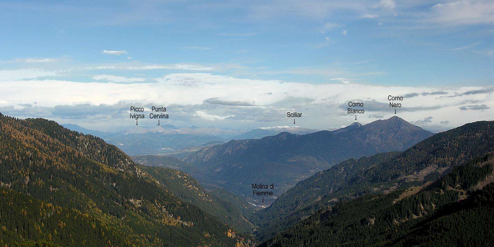
Toward N (from left to right): Picco Ivigna - Punta Cervina - Sciliar - Corno Bianco - Corno Nero. Links are referred to existing SP pages.
How to reach the bivouac
The table shows notices about the two approaching routes. The photo is taken from Passo del Manghen vicinities.
| STARTING FROM... | ROUTE DESCRIPTION | RED TAPE |
|
1) Passo del Manghen. From Borgo Valsugana (from south) or Cavalese (from north) to follow by car the SP 31 that puts in communication the Valsugana valley with the Fiemme valley. Parking at the Passo del Manghen pass. ● When to climb: spring, summer, fall, winter. ● Essential gear: trekking shoes, wind jacket, sleeping bag. ● Essential gear on winter: dressed and heavy shoes, sleeping bag, snow raquets or mountaineering ski. |
Easy and well marked path that for its comfort it used like normal access route. To follow the path SAT 310 that starts from the iron cross of the pass and goes toward west. With some loss and gain of quota, it is arrived in 40 minutes to the Passo Cadino staple (m. 1,954). From here to follow the indication to the bivouac, that is easily reach in 20 minutes. ● Unevenness: m. 15. ● Time in order to go up: 1,00 hour. ● Time in order to return: 1,00 hour. ● CAI degree of difficulty: E (hikers). |
● On winter the local SP 31 remains sluice for a length that depends on the thickness of the snowy mantle. Therefore it is not possible to know exactly of how much increases the time of distance. |
|
2) Malga Valsolero di Sopra. From Borgo Valsugana to follow the SP 31. The mountain barn finds 3 km. before the Passo del Manghen pass. Parking place near the barn. ● When to climb: spring, summer, fall, winter. ● Essential gear: trekking shoes, wind jacket, sleeping bag. ● Essential gear on winter: dressed and heavy shoes, sleeping bag, snow raquets or mountaineering ski. |
This path goes directly from the mountain
barn (m 1,750) until the Passo Cadino staple (m. 1,954) and from here to
the bivouac (m. 2,060) without losses of quota. It is not so panoramic
as the 1). ● Unevenness: m. 310. ● Time in order to go up: 1,00 hour. ● Time in order to return: 0,45 hour. ● CAI degree of difficulty: E (hikers). |
● On winter the local SP 31 remains sluice for a length that depends on the thickness of the snowy mantle. Therefore it is not possible to know exactly of how much increases the time of distance. |
Summits and passages
| ASCENTIONS FROM THE BIVOUAC | PASSAGES AND ROUTES |
|
● Monte Cadino m. 2,112 ● Cima Fornace m. 2,225 ● Monte Croce m. 2,490 ● Monte Ziolera m. 2,478 |
● To the Tonini refuge through the Passo Cadìn pass and the Passo Scalet pass. Paths SAT 310-314-407-460-340. Long hiking route that leads until NW side of Monte Rujoch. Hours 4,00. CAI degree difficulty: E (hikers). |
Maps and books
• Advised book: Mario Corradini, "Lagorai Cima d'Asta", Touring Editore, Milano (Italia), 2006.
• Advised book: Luigi Faggiani, "Guida ai Bivacchi del Trentino Orientale", Euroedit, Trento (Italia), 1996.


