

rasgoat - Apr 13, 2009 8:02 pm - Voted 10/10
Very niceI miss the desert!

Scott - Apr 13, 2009 10:19 pm - Hasn't voted
Re: Very niceThanks. It was a great trip.

goofball - Apr 16, 2009 11:40 pm - Voted 10/10
cooli like your shot much better than mine. having a human for scale really helps out too.

lcarreau - Apr 25, 2009 11:47 pm - Voted 10/10
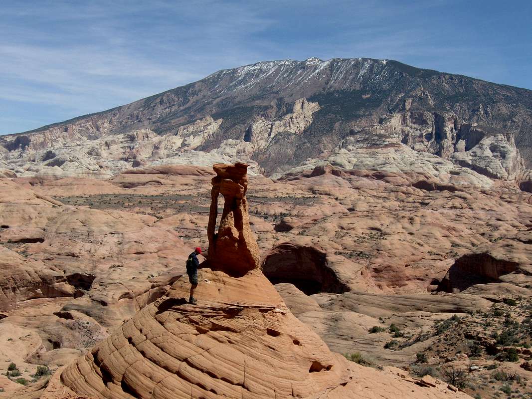
Redbud Pass ?Awesome formation/information - you're the first person I've actually seen next to the landmark.
Nice to see the bit of snow on Navajo Mountain!
Excellante! Great to know the formation is
still there after 15 years. Looks like the
primary stages of the formation of arches
in the background to the right ...
Scott - Apr 26, 2009 9:23 pm - Hasn't voted
Re: Redbud Pass ?Redbud Pass ?
Redbud Pass would be pretty far from the photo. This area is actually several miles west. It sounds like you have seen this formation? It's pretty cool.
lcarreau - Apr 28, 2009 11:31 am - Voted 10/10
Re: Redbud Pass ?Negative - perhaps I was there in another
life ???
I'm not asking for the exact location (by the numbers), I just concur with you regarding the "utter isolation" of this landmark. It's probably closer to Rainbow
Bridge than Redbud Pass ???
Scott - Apr 28, 2009 8:57 pm - Hasn't voted
Re: Redbud Pass ?It's probably closer to Rainbow
Bridge than Redbud Pass ???
As the crow flies, it's not too far from those places, but on foot it would be two days to that area. The Forbidding/Cathedral benchlands are much more isolated and harder to get to than Redbud Pass or Rainbow Bridge.
If you are interested, here is a map with the approximate location of the formation in contex with the positions of Redbud Pass and the Rainbow Bridge area. Look for the red circle on the lower left of the map:
Map
It's a cool place to explore.

Bubba Suess - Apr 6, 2012 10:28 pm - Voted 10/10
Awesome!This is a very, very cool shot Scott.

Oscar68 - May 18, 2014 3:15 pm - Voted 7/10
Unusual view of Navajo MountainYes it is ...I like the light brushing of snow on the ridge...you can see the maze of canyons below and around...What a great that must have been..
Scott - May 20, 2014 10:17 am - Hasn't voted
Re: Unusual view of Navajo MountainYes, I think this is one of the best places to view the mountain. Around Bald Rock Canyon is a good place as well.
Wawrzyniec - Nov 3, 2014 3:46 pm - Hasn't voted
CoordinatesHello! We have been looking for this rock for years on google earth and google maps. We have finally found something that we think might be it. We were wondering, if you could do us a favor. Could you please take a look at this coordinates and tell us if this is the place? We would be very grateful! The coordinates are: 37° 4'37.64"N 110°59'28.85"W Thanks in advance, you are a lucky man that you have seen that unique rock!
Wawrzyniec - Nov 5, 2014 3:16 pm - Hasn't voted
Re: CoordinatesThanks! Could you please provide us with some tips or directions on getting there? We knwo this is Navajo land and that wandering there without a permit is forbidden. Any help will be very much appreciated.
Scott - Nov 5, 2014 5:29 pm - Hasn't voted
Re: CoordinatesYou have to get a permit. We access the rock via Forbidding Canyon:
Forbidding Canyon
We climbed up the wall somewhere near the first waterfall below the Cliff Canyon/Aztec Creek junction.
Wawrzyniec - Nov 8, 2014 5:53 pm - Hasn't voted
CoordinatesThank you very much. What was your starting point? Where did you park your car? Is it possible to get there and return in one day? Unfortunatey I can't access your link. Are ropes required?
Scott - Nov 8, 2014 9:13 pm - Hasn't voted
Re: CoordinatesI fixed the link. No, you can't get there in a day. I'd recommend at least six days, at least if you come down Aztec Creek. If you get there from the Rainbow Bridge Trail, it is shorter, but still around four days or so.
You can start at either the ruins of the Rainbow Lodge or Round Rock.
No ropes are required, but they are certainly useful in a few places along Aztec Creek.
PS, I think your Google Earth coordinates are very close.
Wawrzyniec - Nov 11, 2014 10:53 am - Hasn't voted
Re: CoordinatesHello Scott! Thank you so much for your help! We are a family from Poland spending each year hollidays in southwest. We've seen already pretty much of America, but Hourglas Rock is still on our list.Your webside is a great inspiration for us.Thanks once again. Greetings from Poland.


Comments
Post a Comment