Overview
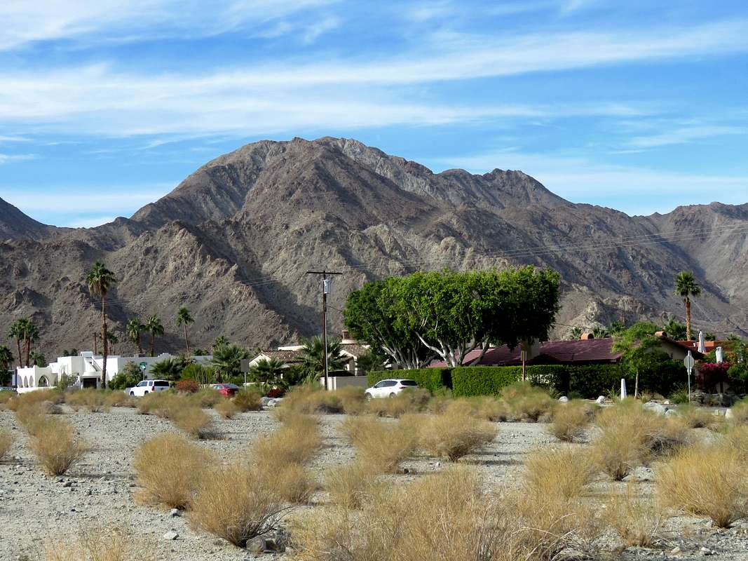
![]() East/southeast face of Indio Mountain from La Quinta, California
Rank:
East/southeast face of Indio Mountain from La Quinta, California
Rank: Indio Mountain is California’s 8859th highest ranked peak
Prominence: 726 ft
Indio Mountain rises above the community of La Quinta near Indio/Palm Springs in southern California. No trail goes to the summit of Indio Mountain. From The streets of la Quinta, I went up a valley/canyon to a 1820 ft high saddle to the north of Indio Mountain. On my way, I ran into a dry waterfall that required some hand and foot climbing to bypass. From the saddle, easy walkup led me to the summit. For the return trip, I headed south from the summit of Indio Mountain bypassing the slopes of Point 2121 ft to the west of it until I reached a 1500 ft saddle between Indio Mountain and Coyote benchmark. I was then able to hike back to the starting place to create a 7.5 mile loop hike.
The summit of Indio Mountain provides you with fantastic views of urban sprawl in Coachella Valley. Major peaks of the area such as San Jacinto and San Gorgonio will also be in good view.
Getting There
A good place to park is at the designated parking area for Bear Creek Canyon Trail in La Quinta, CA (you will obviously not be following Bear Creek Trail).
From I-10 near Palm Springs, take Exit 139 to Jefferson St. and drive 5.75 miles south. Turn right (west) onto Avenue 52 and go 2.5 miles then turn left (south) onto Avenida Bermudas. Go to the end of the development where you will see designated parking areas on the left.
Route
Starting Point Elevation: 310 ft
Elevation at Lowest Point: 190 ft
Summit Elevation: 2226 ft
Distance: 7.5 miles loop hike as shown on map
This is a description of my counterclockwise loop hike as shown on the map.
From the parking area, I headed west hiking along Calle Tecate Street to a concrete pathway know as Fred Wolff Bear Creek Trail. Turned north and followed the concrete pathway downhill until I could see the 1820 ft saddle to the north of Indio Mountain to my northwest. I left the concrete pathway, headed west crossing a dry wash and going on a boulder covered flood plain.
Continued northwest toward the 1820 ft saddle.
![1820 ft saddle]() 1820 ft saddle
1820 ft saddle
The plain tapered to a canyon.
At an elevation of 800 ft, I reached a dry waterfall creating an impassible barrier to me.
![Dry waterfall]() Dry Waterfall
Dry Waterfall
Went up the rocky slopes on the left (southeast) side of the canyon and climbed a 5 ft tall wall to a catwalk that allowed me to bypass the dry waterfall. Looking down at the dry fall from the catwalk.
![Bypassing the dry waterfall]() Dry waterfall from the catwalk
Dry waterfall from the catwalk
The boulder filled canyon continued beyond the dry waterfall .
Looking back at La Quinta.
![La Quinta]() Looking back at La Quinta
Looking back at La Quinta
Horn on the slopes of Indio Mountain.
I then reached the broad 1820 ft saddle. Looking north toward Point 2100 ft and Eisenhower Mountain.
![1820 ft saddle]() 1820 ft saddle
1820 ft saddle
Went up the slopes to reach the summit of Indio Mountain which turned out to be a large area with many piles of boulders reminiscent of what I had seen in Joshua Tree National Park. It was hard to say which pile was the summit.
Views from the summit of Indio Mountain.
![Indio and La Quinta]() La Quinta & Indio La Quinta & Indio |
![Eisenhower Mtn & Point 2100 ft]() Eisenhower Mountain & Point 2100 ft Eisenhower Mountain & Point 2100 ft |
![Mt. San Gorgonio]() Mt. San Gorgonio Mt. San Gorgonio |
![Mt. San Jacinto]() Mt. San Jacinto Mt. San Jacinto |
![Palm Canyon]() Palm Canyon Palm Canyon |
![Martinez & Santa Rosa Mountains]() Martinez & Santa Rosa Mountains Martinez & Santa Rosa Mountains |
For the return, from the summit of Indio Mountain, I headed south along the ridgetop toward Points 2180 and 2121 ft.
![On the ridgeline south of the summit]() Coyote Benchmark & Point 2180 ft
Coyote Benchmark & Point 2180 ft
Looking back at Indio Mountain.
La Quinta and Point 2180 ft from the saddle between Indio Mountain and Point 2180 ft.
![La Quinta & Point 2180 ft]() Point 2180 ft
Point 2180 ft
I then began traversing the western slopes of Points 2180 and 2121 ft.
Looking west at Mt. San Jacinto.
I then reached the 1500 ft saddle between Point 2121 ft and Coyote Benchmark. Looking southeast toward La Quinta.
From the saddle, I followed a faint trail toward the dry wash and Fred Wolff Bear Creek trail. La Quinta and Peak 1601 ft.
![La Quinta and Peak 1601 ft]() La Quinta & Peak 1601 ft
La Quinta & Peak 1601 ftRed Tape
No fees or permits needed.
When to Climb
Winter is the best time to climb. summer can get dangerously hot.

 East/southeast face of Indio Mountain from La Quinta, California


 1820 ft saddle

 Dry Waterfall
 Dry waterfall from the catwalk

 Looking back at La Quinta
 1820 ft saddle
 La Quinta & Indio
 Eisenhower Mountain & Point 2100 ft
 Mt. San Gorgonio
 Mt. San Jacinto
 Palm Canyon
 Martinez & Santa Rosa Mountains
 Coyote Benchmark & Point 2180 ft
 Point 2180 ft


 La Quinta & Peak 1601 ft