Lone Peak Attempt #1- Snowy Surprise
On the weekend of September 23, I decided to attempt something I heard about on my King's Peak hike a few weeks prior. Toward the end of that hike, the nice man with whom I discussed this great nation informed me of Lone Peak, telling me of its challenging aspects, its steep ascent, and the scary, as he put it, experience of summiting via the summit ridge. Little did I know that, coincidentally, I was to find myself swapping tents in Salt Lake City soon after this conversation, which conveniently put me a cairn stone's throw away from Jacob's Ladder trailhead, one of the more popular trailheads leading to the formidable more-than-vertical-mile ascent toward the top.
Certainly with planning being a bit of a weak spot for me thus far, I was disappointed but hardly surprised to find myself unsure of the trailhead's location at approximately 2:00 p.m. on Saturday, the 23rd in the Draper, UT area. But this instance was a certainly necessary growing pain. Nonetheless, double-checking SummitPost's directions to the trailhead beneath the "Trailhead" portion of the Lone Peak page, I scrolled around on Google Maps on the phone in order to hone in on the area at which the trailhead seemed to reside. Corner Canyon Gate was not coming up in Google Maps. Re-reading was necessary. "It is 2.6 miles up the dirt road from Corner Canyon Gate at 2000 E and 12600 S in the town of Draper," the directions read. I located what looked to be 2000E and 12600S on the map, and, pressing my finger on this intersection, the little red pin appeared on the map. The Google lady navigated the rest of the way. Arriving at this coordinate, the Orson-Smith trailhead was there. I double-checked SummitPost's Lone Peak page again, and of course I felt like a dummy. It read plainly beneath "Getting There": "#1 Jacobs Ladder via Corner Canyon Road (access road from Orson Smith trailhead) and Jacobs Ladder Trailhead "
![Access to Jacob's Ladder trailhead via Orson-Smith trailhead/parking area]() Access to Jacob's Ladder trailhead via Orson-Smith trailhead/parking area
Access to Jacob's Ladder trailhead via Orson-Smith trailhead/parking area
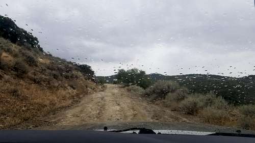
I headed down the unpaved road that is connected with the paved Orson-Smith trailhead parking lot.
![Finally heading toward Jacob's Ladder trailhead.]() Finally heading toward Jacob's Ladder trailhead from Orson-Smith parking area.
Finally heading toward Jacob's Ladder trailhead from Orson-Smith parking area.
Clearly the weather was unfavorable, but determination to get into the hills won the day. If nothing else, this adventure was sure to be a good reconnaissance opportunity coupled with a new solo tent test. After changing into my hiking outfit, the trot up approximately two miles of an easy incline began by walking down the large dirt road from the parking area, and then taking a left at the Jacob's Ladder sign on the other side of the road. I emphasized the taking-a-left part because I actually had glanced at the Jacob's Ladder sign there on the right side of the dirt road while absentmindedly walking right by it, continuing probably a quarter mile down the road until something didn't feel right. Fortunately I trusted the feeling by turning around. Returning to this Jacob's Ladder sign, now on my left, there was the trail across the road from it on my right! The trail forked--I could go left or right. Did it matter? I chose right, thus officially beginning the hike up Jacob's Ladder trail.
![Jacob's Ladder parking to the trailhead.]() Jacob's Ladder parking to the trailhead.
Jacob's Ladder parking to the trailhead.
![Jacob's Ladder trailhead to Lone Peak]() Jacob's Ladder trailhead to Lone Peak (top-right). The dirt road (i.e. Draper-Alpine Trail) from the Orson-Smith trailhead is visible.
Jacob's Ladder trailhead to Lone Peak (top-right). The dirt road (i.e. Draper-Alpine Trail) from the Orson-Smith trailhead is visible.
Approximately ten minutes of hiking brought me to an intersection and another sign that read "Ghost Trail trailhead." The sign showed an arrow pointing in the direction from which I'd just come. A trail was to my left and to my right now. The left one must be from the left trail I decided against down at the trailhead entrance, I thought. Right was the choice once more, and slowly but steadily the elevation rose. As one commentator put it in regards to this trail, the first two miles were a nice warm-up for what was to come. But a warm-up wasn't exactly accurate on this day given dramatic gusts of wind and rain from the direction of the mountain. I was quickly wet, but the thermals were plenty in providing warmth as I forged onward.
Perhaps after a mile, a view depicting the fall season upon us came into sight. The gusts of wind reminded me of fall as well. Not the wind itself, but the sound of the wind as it came and went through every bush and tree in its path. The fresh smell of rain and vegetation was within the gusts as well.
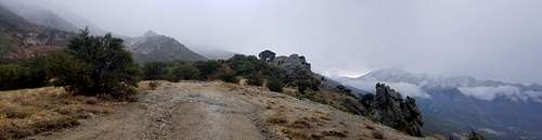
![Before heading north toward the true ascent of Lone Peak.]() Before heading north toward Lone Peak.
Before heading north toward Lone Peak.
Progressing up the trail, I finally came to a Jacob's Ladder sign that reassured hopes of being on the right path. Into the woods I went. Then up steep rock beds that made surprisingly good natural staircases. The rain was abating, then getting replaced with light snow. Coming around a corner near the 6500-foot mark on my altimeter, there stood a man taking in the foggy views of the city below.
"You make it to the top?" I asked.
"Not quite. I just got close enough to see the peak. You camping up there?"
"Planning on it. I'd like to summit and camp somewhere below, but I don't know about summitting in this weather."
"Yeah, it's like a blizzard up there toward the top."
And it certainly wasn't long before a frosting of snow became ankle-deep snow. It was clear I was on the right track upon finding a small cairn perched on a boulder in a rather open area of trail that was surrounded by larger boulders. Not much of a cairn, I thought to myself, but still good. Then another cairn was perhaps 30 feet away. Those were the only two in the area that I could see though, so I simply followed a pathway that continued up the mountain. Then, near about 8000 feet, at probably 6:00 p.m., I heard voices up above. A younger couple came from around some brush, and they were descending. A brief chat ensued.
"What are you doing?" the woman asked me cheerfully.
"I'm headin' up to see what it's like up there. Did y'all make the summit?"
She smiled and pinched her fingers together to emphasize how close they'd come to it. Then the man chimed in.
"We got about 40 feet away, but we didn't want to die, so we didn't go any farther," he said.
"Yeah, I figure I'll get as close as I can, but I'm not doing anything crazy," I said, always keeping in mind Ed Viestur's famous words, "Getting to the top is optional. Getting down is mandatory."
They told me of a decent camping spot maybe 800 feet up. We each agreed that it'd be nice to have some tracks to follow since the trail was now getting covered in snow more and more. They'd been using the AllTrails app to help them down, the man had said. Sure enough, the Jacob's Ladder reviews were accurate in their warnings of the trail's difficulty to follow at times.
Proceeding along the sometimes direct, sometime switchbacking trail, at perhaps 800 feet higher from where I'd spoken with the couple, I seemed to find the camping place that the man referred me to. The wind gusts seemed more steady at this elevation. Snow was falling more consistently as well now. After standing there for a few minutes and hesitating about camping here due to wind exposure from the north, I began unrolling my new tent from its pouch. Hastily I staked down the tent so as to keep it from blowing away. Snow quickly began sprinkling it. Remembering reviews of this new tent, some people had written of issues they'd had putting the fly on. Thoughts began racing through my head. Here I was getting colder while it was getting darker, and I could sit here for however long struggling to get the fly on before being able to bundle into my sleeping bag. As I brought the tent poles out, I looked down at the tent. More snow was on it only after a few minutes. Some flakes even seemed to be going through its mesh onto the floor inside. A wave of panic rushed over me as I looked at the tent poles in my hand. Darkness was falling. Wind was gusting. And here I was, a novice backpacker in the snow with a tent he'd never pitched before. As quickly as I could, I rolled the tent back into its pouch, reattached it to my backpack, and I went storming down the trail, nearly tripping over myself at times. The descent took me below where I'd spoken with the couple, and then below the two cairns from before.
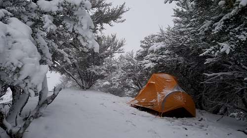
I felt warmer and more calm now. The elevation was nearly 7500 feet. Knowing that if need be I could just follow my compass on a 200-degree bearing while bushwhacking to reach the easy trail that led back to the trailhead, I chose a less exposed place to camp where I could focus on putting the tent together beneath the florescence of my headlamp. Quickly, the tent was up, and I was making final adjustments to the fly, which hadn't been difficult at all to attach. Finally, in the warmth of the tent and zero-degree sleeping bag, some hot tea and macaroni with beans arrived fresh out of the kitchen. It was 22:00 or so.
The wind waxed and waned for the remainder of the night and into the morning. The gusts didn't ever seem to exceed 30 mph or so. Sleep was relaxing, though never deep. Come 06:30 or so, rain seemed to be pelting the tent. It was actually sleet, which dissipated soon after this discovery. More tea and then some scrambled eggs got me going. I stepped outside to look up toward the peak. Camp was a pleasant, wintry sight. The upper mountain was invisible, shrouded with fog. The chance of a whiteout concerned me while considering an ascent.
![Camp at approximately 7500 feet in Loan Peak area.]() Camp at approximately 7500 feet near Jacob's Ladder trail.
Camp at approximately 7500 feet near Jacob's Ladder trail.
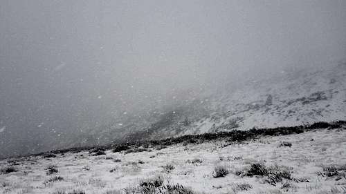
Nonetheless, I decided to pack up and see what happened by hiking upwards again. I had my ice axe out and some Yaktrax traction spikes on the boots. Then back to thinking about the whiteout possibility. Heading up through the fresh snow, I wondered if I could manage descending with five or ten feet of visibility. I had a compass, plus I wasn't too far from civilization. But I wanted willow wands. For this being the first time here on this mountain, the lack of willow wands would come to be the deciding factor in whether or not to really close in on the summit. Heading up farther, snow was pelting me in the face. Was it sleet or snow? Snow was falling for certain. Either way, the precipitation would be falling vertically during lulls in the gusts, and then the wind would blow hard directly down the mountain toward me. So at approximately 9000 feet I stood there and took in the view. Then the descent began.
![Low visibility near 9000, a couple thousand feet below the top.]() Low visibility near 9000 feet, a couple thousand feet below the top.
Low visibility near 9000 feet, a couple thousand feet below the top.
On the way down, the heel part of one of my Yaktrax Extremes broke--the metal tore through one of the rubber eyelets. This was disappointing though not surprising given that the conditions seemed inappropriate for the device in the first place. Still, the spikes definitely helped at times. What was the right device?, I thought to myself. Going down the steep slope through fresh snow that covered smooth rocks at times might've been easier with trekking poles. Nonetheless, my technique of hiking downward with my ice axe and the Yaktrax sufficed perhaps 99% of the time. The other 1% of the time you could find me cursing while falling on my rear or my side as I skidded down steep grades of smooth, small snow-covered boulders. One might say that this was the most elementary lesson for me as to why most deaths happen on descents among most all great mountains of the world. Taking it even more slowly became my stride for the remainder of this snowy descent.
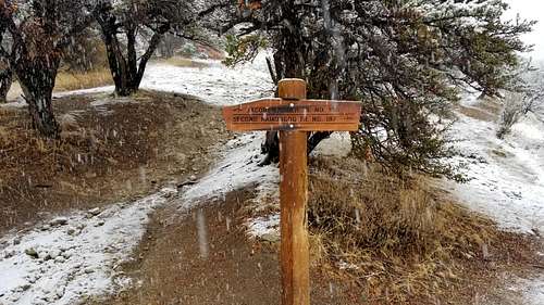
It was difficult at times to know if I was in the bush or on the trail mainly due to how the snow changed the appearance of the environment. Regardless, with my ice axe I whacked branches that were suspended over the path in order to remove the weight-bearing snow from their leaves. This would mostly return the branches to their pre-snow-caked status, therefore allowing me to pass by them without becoming caked in snow myself. Soon enough, heading eastward, or left while hiking down the mountain, I was in a clearing. This seemed to inevitably be a trail. Then I approached the sign I'd passed on the way up, not to be confused with the very first sign I'd seen at the beginning of the trailhead.
![Jacob's Ladder sign after a snowy descent]() Jacob's Ladder sign after a snowy descent.
Jacob's Ladder sign after a snowy descent.
This was essentially the end of the hike, though a couple more miles were necessary to reach the real trailhead. The snow turned to rain. The trail got muddy and slippery. Finally I reached the vehicle, enjoying the luxury of changing into dry clothes and turning the heat on. I will return, I thought, when the time is right, with a better knowledge of the mountain, the weather forecast, and my abilities.
Comments
No comments posted yet.