
-
 11298 Hits
-
 77.48% Score
-
 8 Votes
|
|
Area/Range |
|---|---|
|
|
47.05832°N / 104.66662°W |
|
|
Hiking, Scrambling |
|
|
Spring, Summer, Fall, Winter |
|
|
2400 ft / 732 m |
|
|
Overview

Not surprisingly, the name Montana conjurs images of mountains, and lovers of the state will passionately defend the peaks of places such as Glacier National Park, the Bob Marshall Wilderness, the Bitterroot Range, and the Beartooth Mountains, and others as the most beautiful in the country.
But only about one third of Montana, its western third, is really mountainous. Most of the state belongs to the Great Plains, and it is out on the plains of eastern Montana that one truly comes to understand the idea of "Big Sky Country."
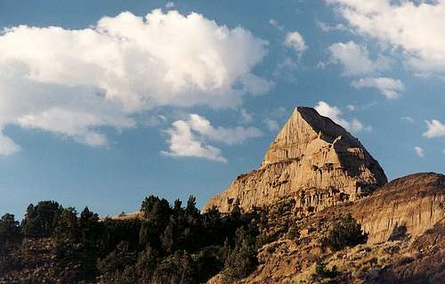
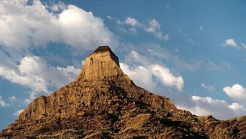
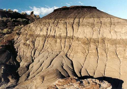
In some of the drier areas of the plains, rivers such as the Missouri, the Yellowstone, and their tributaries have carved the land into extensive networks of badlands that create a landscape like something out of a science fiction or fantasy film. Makoshika State Park (Mah-KO-shi-kah), just outside the town of Glendive and about 30 miles from the North Dakota border (and about an hour's drive from larger, relatively lightly visited Theodore Roosevelt National Park), protects an exceptionally spectacular area of badlands almost a stone's throw away from the mighty Yellowstone River, here a meandering, slow-moving stream far unlike the rushing green waters that rise south of Yellowstone Lake in the Thorofare region of Yellowstone National Park.
Makoshika State Park was established in 1953 and is Montana's largest state park. Citizens began advocating for park status as long ago as 1892, and the federal government once considered the area for national park status. In fact, the feds built the first road here back in 1939.
History
The rocks comprising the badlands at Makoshika are from the Cretaceous Period 65 million years ago, when the Rockies were but young mountains rising to the west. Back then, though, the area was rich with rivers and floodplains and had a subtropical climate. It was home to dinosaurs, and many fossils have been uncovered here. The most famous finds are bones from tyrannosaurus rex and triceratops; the three-horned skull of a triceratops, found within the park boundaries, is on display at the visitor center.
The area was also known to the Lakota Sioux. They referred to it as Ma-ko-shi-ka, which meant "bad land," "bad earth," or "land of bad spirits."
Activities
The park has 4 miles of paved roads and 12 miles of unpaved ones (the latter can be impassable when wet and are recommended for high-clearance vehicles), and these roads access 3 hiking trails. Off-trail exploration is permitted as well. Badlands peaks make fine summits for short scrambles, but the soils can be unstable. Please preserve the resource and protect yourself by staying off the softer "peaks" and by avoiding all "peaks" during wet conditions.
The three developed trails are the Diane Gabriel Trail, the Cap Rock Nature Trail, and the Kinney Coulee Hiking Trail. The trails are easy to moderate in difficulty and short in length. Free trail guides are available at the visitor center.
Weather can be extreme here. Winters on the Montana plains are brutal-- bitterly cold with seemingly ceaseless winds. Summer days can exceed 100 F.
Getting There
Exit I-94 at Exit 215 for Glendive and follow signs a short distance southeast of town to the park.Red Tape, Camping, and Lodging
Fees and Hours
Daily use fees are $5 per vehicle and $1 per person; I do not remember if this means you pay an additional dollar per person in a vehicle or if it only applies to people not entering by car.
Montana residents do not have to pay the fee if they have paid a $4 fee with their vehicle registration; this fee grants access to all state parks for a year.
The park is open 10 A.M.-6 P.M. Memorial Day through Labor Day and 9 A.M.-5 P.M. the rest of the year. I am assuming this refers to facilities, especially since sunset in Montana can be close to 10 P.M. in the summer; any clarification from Montana residents or others who know is welcome.
Camping
The park has a campground, open May 1-September 30, that charges $12 per night. Open-range camping is also permitted. Water and flush toilets are available at the visitor center and developed camping areas.
Lodging
As an alternative to camping, especially in summer, consider staying in the town of Glendive, which has full services, including some low- to medium-priced motels.
External Links
mt.gov Makoshika pageMakoshika article from Montana Outdoors
Park website
Park map