
-
 62224 Hits
-
 95.18% Score
-
 51 Votes
|
|
Mountain/Rock |
|---|---|
|
|
41.56861°N / 123.21133°W |
|
|
Siskiyou |
|
|
Hiking, Scrambling |
|
|
6990 ft / 2131 m |
|
|
Overview
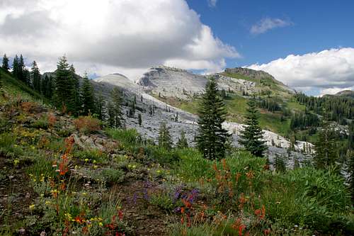
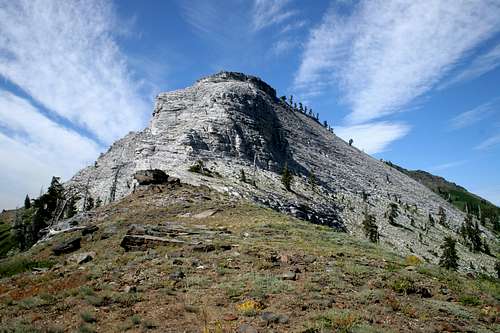
Marble Mountain
Composed of stark white marble, Marble Mountain is one of the most unique mountains in America. The distinctive chunk of rock is the obvious centerpiece and namesake of the Marble Mountain Wilderness, one of the great American wilderness areas. The peak is located in the heart of the Klamath Mountains, a range composed of a cacophony of rock types ranging from glacially polished granite to bright red serpentine and peridotite. Even still, the vivid white cliffs of Marble Mountain are as stunning as they are surprising and unexpected. Contrasted against the blue sky, green trees and meadows and the black schist of adjacent Black Marble Mountain, the white marble of Marble Mountain is a spectacular image that is not quickly forgotten.
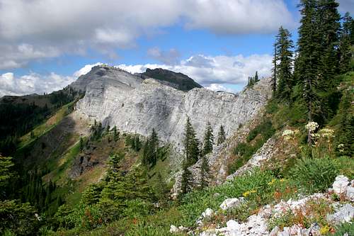
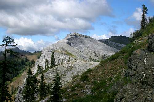
The Marble Rim
Although the mountain is the most notable, it is not the highest point in the vicinity. That honor goes to the formation incorrectly called Black Marble Mountain, which is located next to Marble Mountain. Boulder Peak, the highest summit in the Marble Mountains is found across the Canyon Creek drainage from Marble Mountain. Nonetheless, the peak is far and away the most visible and recognizable object in the area. Marble Mountain is not a distinct peak like most prominent points identified as mountains. Instead, the peak forms a long, curving, escarpment with numerous highpoints along the rim. The eastern side of the mountain has an extensive, gradual slope that terminates in Marble Valley. All approaches to the top save one are on this side. The western side drops away in sheer cliffs two thousand feet above the Rainy and Elk Creek drainages. Because Marble Mountain forms a long escarpment, it is often referred as the Marble Rim. The Marble Rim is broken into two sections by a gap roughly located in the center of the formation. Some maps identify the high point of the larger, southwestern half as the actual summit. Although higher, the part of the Marble Rim northeast of the Marble Gap is sometimes identified as part of Black Marble Mountain.
Views from the Rim are astounding. Looking southwest, the entire Wooley Creek drainage is apparent as the creek tumbles 6,000 feet into the Salmon River. Wooley Creek is the primary drainage of the Marble Mountains. To the north, Kings Castle is visible, as well as the Klamath River canyon and the High Siskiyous, the awesome Preston Peak being the most prominent peak visible. Looking south, one can observe the high peaks of the Trinity Alps. The Thompson Glacier is clearly visible. Other peaks in the Marble Mountains surround the Marble Rim. The Maneaten Group and Boulder Peak are particularly prominent.
Geography
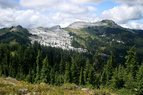
The Marble Rim from above the Sky High Lakes
The Marble Mountains Wilderness is one of the premier wilderness areas in California. Far from any major urban centers, it remains a land that is vast and wild. The region was initially set aside as a Forest Service Primitive Area in the 1930's. It was in the original class of wilderness areas created with the passage of the 1964 Wilderness Preservation Act. The Marble Mountain Wilderness currently contains 241,744 acres.
The Marble Mountains are located at the heart of the Klamath Mountains, located in the far northwestern corner of California. North of the Marbles are the Siskiyous, a Klamath mountain subrange. The Siskyou Mountains form an arc, stretching east from the region inland of Crescent City, California to the Bear Creek Valley area around Medford, Oregon. These mountains, along with the Kalmiopsis Wilderness in Oregon constitute the northern portion of the Klamath Mountains. These ranges are separated from the Marble Mountains by the Klamath River. South of the Marble Mountains are the Trinity Alps. This range contains the highest concentration of high peaks in the Klamath Mountains. They are separated from the Marbles by the Salmon River. East of the Marbles is the Eddy Range. Lying between the Eddies and the Marbles is Scott Valley, which is drained by the Scott River. Surrounded by the deep canyons and valleys of the Klamath, Salmon and Scott Rivers, the Marbles are a large but compact cluster of peaks.
The Klamath Mountains are one of the most diverse mountain ranges in the United States. The stark granite of the Trinity Alps is a striking contrast from the serpentine and peridotite of the Red Buttes or the metamorphic rock found in parts of the Siskiyous. The Marble Mountains themselves have a striking array of rock types. The Boulder Peak is a striking contrast from the Maneaten Peaks group, despite their close proximity. Nonetheless, even among the varied rock types of the Marbles, Marble Mountain itself is a unique and striking peak. The blindingly white marble is a unique feature in the Klamaths. Marble occurs elsewhere in the Marble Mountains in places such as the Kings Castle to the north and the Big Elk Lake. However, as beautiful as these areas are, Marble Mountain remains an order of magnitude greater in terms of beauty and its spectacular nature.
Caves
Many of the caves are found in the large sheet of marble beneath the rim
One particularly interesting feature of the Marble Rim are the numerous caves it contains. There are over 150 documented caves, most containing excellent stalactites and stalagmites. One cave is documented to be longer and more extensive than the cave contained in Oregon Caves National Monument, which is located in the upper reaches of the Klamath Mountains in southern Oregon. Due to the anonymity of the caves and the difficulty in locating their entrances, access to the caves on the Marble Rim remain unrestricted. The Forest Service does ask that only serious spelunkers attempt entry.
More information on caves in Marble Mountain, the Marble Mountains Wilderness and other parts of the Klamath Mountains can be found at this site. Thanks to rl23455 for posting the link.
Routes
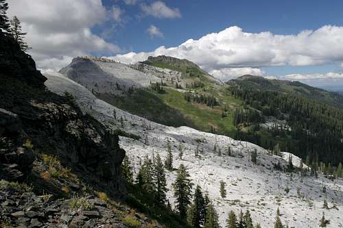
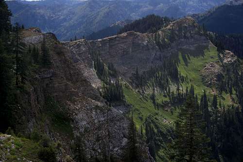
Looking northeast from the Marble Gap
Although it is not located at the true geographic center of the Marble Mountains, the Marble Rim does form the functional center of the wilderness area’s extensive trail network. The mountain is most easily accessed via the Canyon Creek (not to be confused with the Trinity Alps’ popular Canyon Creek) trail. A detailed description of the entire route can be found here.
Other access points to Marble Mountain are generally reached along the PCT. The best of these is to hike to the PCT at Paradise Lake, below the Kings Castle. From here it is a seven-mile trek along the PCT to Marble Valley. Views of the Rim from the north are excellent. Paradise Lake and the Kings Castle are worthy destinations in themselves.
Map
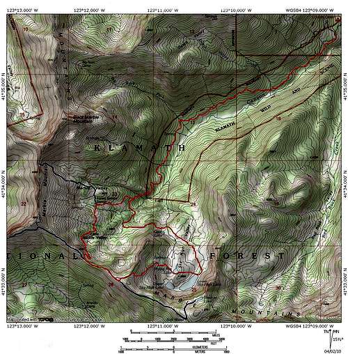 The Canyon Creek Trail to Marble Mountain and Sky High Lakes
Getting There
Looking northeast along the Marble Rim
From Interstate 5 in Yreka take the Highway 3 exit at the south end of town. Take Highway 3 west to Fort Jones, in Scott Valley. Turn right onto River Road and proceed west, following the course of the Scott River. After several miles, turn left, crossing of the Scott River on the Indian Scotty bridge. Proceed past the Indian Scotty campground. The road narrows but remains paved, eventually coming to a dead end at the Lover’s Camp campground and trailhead complex.
Other trailheads, including the route to the PCT at Paradise Lake are located off of the road from Indian Scotty.
Red Tape
The western end of the Marble Rim
The Marble Rim is located in the Marble Mountain Wilderness, which is administered by the Klamath National Forest. Normal wilderness rules and ethics apply. A campfire permit is required.
The Forest Service asks that only serious spelunkers enter the caves on the Marble Rim.
Klamath National Forest
1312 Fairlane Road
Yreka, CA 96097-9549
(530) 842-6131
Salmon River & Scott River Ranger Districts
11263 N. Highway 3
Fort Jones, CA 96032-9702
(530) 468-5351
Camping

Shadow Lake
Camping is available at numerous trailheads, including the popular Lover’s Camp trailhead. This site has both backpackers campsites as well as campsites adjacent to horse corrals. Campsites abound around the mountain, along the PCT. Marble Valley has plenty of good sites. An excellent option is to camp at the Sky High Lakes, which are located a couple of easy miles from the Marble Rim. Another great option is to camp at the secluded Shadow Lake. This lake is slung on the cliffs high above the Sky High basin. Few people go to this lake so privacy is guaranteed. It is located less than a quarter mile off of the PCT, a mile south of the Four Corners saddle.
External Links
Klamath National Forest
Klamath National Forest Marble Mountain Wilderness site
rhyang - Apr 1, 2008 3:39 pm - Voted 10/10
Beautiful page !The only comment I have is that the link at the bottom to the Klamath NF's wilderness page has an extra "http" in it. Oh, and maybe a note about suggested months to visit, or perhaps a date or two in the photo captions. The last time I was in this area was early July 2004 and I recall snow on some areas of the PCT.
Bubba Suess - Apr 2, 2008 12:39 am - Hasn't voted
Re: Beautiful page !I am glad you liked the page and I appreciate the input too! I will add a note regarding the conditions. I am actually working up a route page. I have had a long docket of things to do but oddly enough a bad economy means my business goes up, so I have been too busy to post anything in a while. I hope you are doing well!
rhyang - Apr 2, 2008 9:51 am - Voted 10/10
Re: Beautiful page !No worries ! Now that I'm backpacking again I definitely want to visit the Marbles again this year :)
Bubba Suess - Apr 2, 2008 11:08 am - Hasn't voted
Re: Beautiful page !Well...if you want a basecamp in Shasta or someone to go with you, give me a holler!
rl23455 - Jun 1, 2008 5:01 pm - Hasn't voted
link additionFor caving information contacts, see http://kmctf.org can you please add this to the Caving information area also?
Bubba Suess - Jun 3, 2008 11:56 am - Hasn't voted
Re: link additionPosted. Thanks for the link!
Bob Burd - Mar 4, 2012 7:17 pm - Hasn't voted
elevation?The coordinates you provide for the peak correspond to the peak with elevation 6,990ft, just south of the peak with elevation 7,321ft. It's not obvious from the topo map which is the correct point. Peakbagger.com shows Pk. 6,990ft as the correct one, for what that's worth. I honestly don't know - I had thought the point to the south, 6,881ft was it based on another peak list, but again I've no sure idea.
Bubba Suess - Mar 5, 2012 1:54 am - Hasn't voted
Re: elevation?I have really vacillated on this point. At first I went with the 6,990 as the highpoint. I am not sure where, but I remember seeing that point listed somewhere. It definitely is the highest point on the main chunk of the rim. Yet the when I am up there, Pt. 7,321 seems like it is part of the same formation. Thus I changed the elevation after my last trip there. It really comes down to whether you say the Rim ends at the gap or the large marble block on the north side of the gap is part of the Rim. Of course, 7,321 could also be a shoulder of Black Marble Mountain. Here are the angles that I have found useful in reevaluating the issue: http://www.summitpost.org/marble-rim/327267/c-327255 http://www.summitpost.org/marble-rim/327271/c-327255 http://www.summitpost.org/marble-rim/327266/c-327255 Like I said, I have gone back and forth on this one. I am comfortable changing the elevation back to 6,990 if you think that is more accurate. Thoughts?
Bob Burd - Mar 5, 2012 3:41 am - Hasn't voted
Re: elevation?Having never been there, I honestly have no idea which is best called Marble Mtn. The USGS seems to agree by marking the whole ridge with the title, a bit of a cop-out. I just wanted to point out that your coords and elevation are out of sync. Pick whichever you think best and make the elevation/coords match. I noticed that peakbagger.com picked the 6,990-foot point, but they're not a definitive source.
Bubba Suess - Mar 14, 2012 8:24 pm - Hasn't voted
Re: elevation?Just a heads up. I switched the elevation back to 6,990. I think a strong case can be made for the higher point but there is less confusion and alignment with peakbegger this way.
Bob Burd - Mar 31, 2021 11:51 am - Hasn't voted
Marble or limestone?Ok, I finally got to pay a visit a few years ago. Very cool area. It seems to me that all the whitish rock is limestone, not marble at all.