
|
|
Mountain/Rock |
|---|---|
|
|
43.93217°N / 12.45197°E |
|
|
Hiking |
|
|
2425 ft / 739 m |
|
|
Overview
Monte Titano ("Mount Titan") is a mountain of the Apennines and the highest peak in the country of San Marino (a republic surrounded entirely by Italy). It stands at 739m (2,425 ft) above sea level. It was inscribed as a UNESCO World Heritage Site in 2008 under the combined title "San Marino Historic Centre and Mount Titano". The mountainous landscape provides excellent views of its surroundings, and its isolated location ensured the needed seclusion for San Marino to survive as a Republic over the past several centuries.
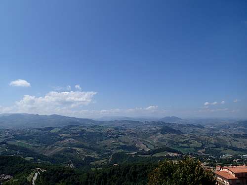
Views
Getting There
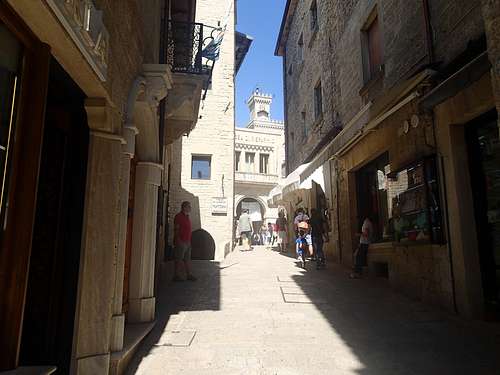
Monte Titano is located in central San Marino, it’s not a big place so don’t worry about finding. It’s 22km (13.5miles) from the coastal beach resort area of Rimini, 135km (84 miles) from Bologna, and 240km (150 miles) from Florence (but this route goes over mountainous terrain, which I drove and was rather treacherous at least the roads that we chose). This mountain is in the center of the touristy area so upon approach you’ll be directed to a parking lot or garage and from there you’ll start your journey.
Route (aka how to Summit)
The highest point is located at the middle peak aka 2nd tower (Cesta), to get there from wherever you park start heading up via cobble stone streets, elevators, and sidewalks. You’ll pass by lots of souvenir shops, restaurants, and other places designed to take your money.
Route Up
I ate at a place outside right at top near tower one which had amazing views although probably too dangerous with the 1 year old I was traveling with. From here there are stone steps and cobble path that leads down into saddle and up to tower two.

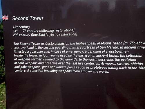
Tower Two
The tower is literally built on the peak so just walk around the base as best you can and go inside and check out the armory museum and you’ve summited.
Sign
It’s fairly interesting museum and you can go up the tower for even more impressive views.

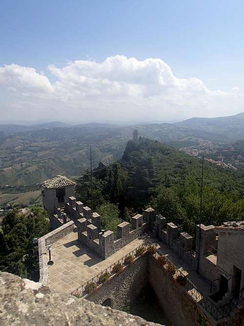
View of Tower 1 from 2
View of Tower 3 from 2
Red Tape
I had to pay to park car in garage. I also think there is fee to the armory museum at the second tower at highpoint, which is worth it for views and looking at all the 535 weapons from the Medieval Era to the end of 1800.When to Climb (weather)
I'm guessing any time of year can be climbed. The precincts of Monte Titano and the San Marino city experiences mild temperate climate; the maximum temperatures reported is of 79 °F (26 °C) in summer while the minimum is 19 °F (−7 °C) in winter. Annual precipitation varies from about 22 inches (560 mm) to 32 inches (800 mm).
Camping
NoneGeography
The mountain has three peaks; on each is one of The Three Towers of San Marino (Guaita, Cesta and Montale). Those three towers are represented in the coat of arms in the center of the National Flag. From the top of Monte Titano the entire nation of San Marino and beyond can be viewed. The mountain gives birth to several streams, including the San Marino River, which flows down its western slope through a broad valley into the Marecchia River, and eventually to the Adriatic Sea.

San Marino Flag
During the Tertiary era, the area where San Marino lies was the sea. Violent earthquakes caused major upheavals in the Earth's surface. Because of these intensive earthquakes, a mass of rock situated about 80 km (50mi) from the mountain, was lifted and slid slowly toward the Adriatic Sea. This mass of rock gave rise to various mountains, including Mount Titano. The vertebrate fossils found on the slopes of Mount Titano are mostly aquatic in origin.
Flora and Fauna
Flora and fauna is typical of the rest of the Mediterranean zone although influenced by a bit of elevation. Numerous trees inhabit the mountain, including chestnuts, oaks, laburnum, cypress, fir trees and some shrubs and asparagus. On the cliffs of Mount Titano is also found Ephedra Nebrodensis, a plant typical of Sicily and Sardinia.
Birds and mammals are the most common animals found in area (Birds: kestrel, barn owl, owl, tawny owl, the magpie and buzzards; Mammals: roe deer, wild boar, deer, weasels,marten, porcupine, hare, hedgehogs, polecats, badgers and foxes.)