
Comments
No comments posted yet.
|
|
Trip Report |
|---|---|
|
|
38.82764°N / 117.04962°W |
|
|
Nov 27, 2020 |
|
|
Hiking, Mixed, Scrambling |
|
|
Fall |
In Pack: ACR Res-Q-Link, compass, 1.5L water bottle, 1L water bottle, backup socks, backup thermal top and bottom, balaclava and beanie, knife, multi-tool, phone with map, flashlight, headlamp, 550 cord, caribiner, stove, snack bars, two freeze-dried camping meals, spoon, fork, lighter, lightly used propane bottle, thin-layer gloves
On Person: Coat, hiking boots, light thermal top, pants, socks, hat, gloves, sunglasses
It was getting dark on Thanksgiving evening. I was at my buddy's house with him and his family in Spring Creek when I told him that I thought I'd go down to the Carver's area to check out the Toquima Range.
"Tonight?" he asked.
"Yeah," I said slowly, perhaps with a slight look of crazy in my eyes.
Ever since the summer when a friend and I trekked into the Toiyabe Range's Arc Dome Wilderness, the more or less parallel range a valley away to the east had been on my mind. We'd noticed a sign at the mouth of a dirt road on the east side of the highway. It indicated that the Alta Toquima Wilderness was down that road. I placed a "pin" where I thought this road was on my new map, and I drove.
Before the drive I found an official map via the free Avenza map app on my phone, and I paid about $5 for the Alta Toquima Range map, one of several detailed Humboldt-Toiyabe National Forest maps that are fortunately available for downloading. I zoomed in on the map so I could see State Highway 376, the highway about 20 miles southeast of Austin, NV, which juts south off of the Loneliest Highway in America, US 50. Looking at the map further, it was clear that this would be a first--if I were to get up onto Mt. Jefferson, I would've for the first time stepped foot in a "research natural area." Upon investigating further, in 1973 acreage of the mountain between 10,000-ft and 11,000-ft elevation was designated this way to further observe and study "Draba, Hulsea algida, Phlos, Eriogonum, Aretmisia frigida, Arenaria, Potentilla, leptodactylon pungens, Pinus flexilis, Populus tremuloides," all species in an environment noted in the InteriorWestRegion_RNA spreadsheet as "Alpine meadow and barren areas cover the plateau and much of the cirques. The few meadows are quite small and are associated with small springs and moist areas."
Interest increased during the drive, and Battle Mountain came quickly in the night. After a fuel stop, the rest of the way was a breeze to Austin and beyond. No snow was to be found on the road, and barely a zyphyr blew through the cold desert air. The car's outdoor thermometer had earlier read 25-deg F, but as I got farther south below Austin, it was showing digits in the teens.
After passing the quaint town of Kingston, which could also be called a village since it only has between 200 and 300 inhabitants, I began looking at my map more closely. Turning on the vehicle's high beams, I approached the waypoint while preparing to see what the sign said. To the right, west, was the Toiyabe Range casting its gargantuan sillhouette against an already dark sky despite a rising moon. The South Twin River access sign was there, which led to the Arc Dome Wilderness entrance that we'd taken in the summer. Immediately after passing it, on the left side of the road shone a sign that read Toquima Range Road. I compared this with the map on my Rand McNally Road Atlas, and I could see that I was at a major dirt road that meandered around the north end of the range, eventually meeting up with another dirt road that went north and south, that connected Eureka to Manhattan, that went between the Toquima Range and, to its east, the Monitor Range. The excitement was palpable. It was approximately 22:30, which lent plenty of time to finding a good place to car camp for the night along the range's northern end.
For approximately 30 minutes I strolled along a well-maintained dirt road that seemed to keep ascending up toward the mountain. I was thinking about the elevation of the camp while comparing it to the elevation of the north summit, which was at approximately 12,600 ft. At best it seemed that camp would be at 9000 ft, but it seemed more likely to be lower. This meant for a hell of a day of ascending. The road then began descending. This seemed to be near the northernmost point of the road, and I knew that one of the small roads on my map that leads south toward the mountain would have to do for the night. After passing the road I'd end up picking, an awkward 6-point turn was in order so I could get back to it. Carefully entering the narrow, seemingly cobblestoned pathway, 100 yards or so had my vehicle and I tucked away for the evening. The pathway went farther, but it seemed a ruthless path to a full-sized SUV.
Looking at the map one more time, it was clear that I was near the Moores Creek trail, though with the car thermometer now reading 8-deg F, the creek, if audible during the warmer months, had some time ago been silenced by the cold.
After sleeping perhaps three hours awkwardly stretched out in the back of a moonlit, frost-covered vehicle, I felt a sense of hurry. Sunlight was filling the sky, and I knew that the ascent was going to take several hours. After making sure that both my liter and liter-and-a-half Nalgenes were full, I suited up fully and started with a Clif Bar in hand. If it had really been anywhere near 8-deg F when I found camp, it had warmed up in the night. I couldn't see my breath, and I was quickly debating removing my thermal top layer from beneath my coat.
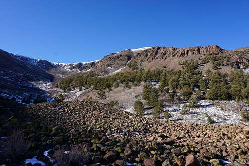
After the first quarter mile or so, hiking became nothing short of bushwhacking and making sure that I didn't bust my ass in the creekbed that was now frozen solid. My map showed several springs were in the area. Wherever these occurred, their frozen, milky appearances were remarkable sights. One occurred just slightly uphill from the main creek I was using to navigate:

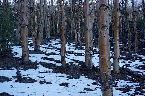
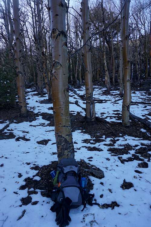
The creekbed led me up into a grove of trees that I believed to be aspens. They surrounded this section of the creek on the mountainside that was now steeper than any part I'd climbed so far. The going got tough at this point because of the countless patches of snow on this now steepening section. But ever so slowly I reached the ridgeline that I'd been hiking up to. A couple of bighorn sheep reluctantly greeted me before they scurried down the mountainside, crossing the path that I'd just taken to get up it.

The sky was immaculate, perhaps more so than I'd ever seen, without, literally, a cloud in sight. It was then breaktime near where the bighorns had stood.

After taking some pictures, I felt fatigued some. It would be a lot more work to go farther up the mountain. Alas, though, this is what a challenging hike is all about. It was obvious that I'd have to drop down slightly from the peak that I was on, but then I could either ascend a ridgeline full of trees, or I'd have to drop slightly farther to follow another stream system that led into a valley below the northwest side of the mountaintop. This route seemed more promising in terms of being able to find a definite way up while the ridgeline option seemed likely to involve postholing and possible impasses that were invisible from my current vantage point.

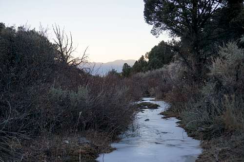
Passing into the wilderness boundary, a signed indicated that motor vehicles were not allowed beyond that point. I ironically followed vehicle tracks for another 100 yards or so. Soon enough, however, the vague roadway disappeared. I was quickly on a hillside wishing there was a trail somewhere. Upon more traversal in the direction of the valley's mouth, perhaps 30 feet downhill from my location was what appeared to be a trail. After descending the relatively steep grade, the trail's existence was definite. Shortely after contiuing, an added bonus to the situation was a series of pink plastic ribbons that marked the general direction of the trail every 50 feet, all the way up into the valley. These ribbons quickly became helpful since existing snowcover hid a lot of the trail quite well. Farther into the valley, another frozen stream sat still within a ravine. This was more substantial than the one a valley lower though. The map still didn't indicate that it had a name, but it was the first time I'd seen a sizeable stream frozen solid.

At some point near the creek I began getting concerned about water and if I'd brought enough. As slow as my water consumption had been, I knew that going higher was going to take a lot more breathing and therefore more water. And so far, all water sources on the mountain were proving to be frozen. And at the time my fatigued state of mind didn't even consider melting or simply eating snow to conserve the water that I carried.
After 30 to 45 minutes or so, I found myself faced with another decision: Ascend the east side or the west side of the basin. The west side required traversing tree-scattered slopes while the steeper east side was nothing but rocks. But curiosity got the better of when looking to just east of the trail. Perhaps 100 yards away and 40 or 50 feet up looked like a lake's edge. About 15 minutes later I was observing a massive field of earthen rocks blotted with chartreuse-colored lichen. Going up to my left then seemed more inviting at the time, though I now know that that way was much more difficult than the other side would've been.

This section of ascent was the most difficult for me in recent memory. I was quickly reminded of ascending the north side of Bonney Pass during the summer's Gannett Peak expedition. The exhaustion was not just of the physical, for to push yourself well beyond feelings of physical exhaustion becomes a test of mental fortitude. Either way, in both situations, and in perhaps others, it was a matter of patience and one step at a time. Without the altimeter, I could only guess at the elevation. Probably 10500, I thought. It had better be, I pondered further, because the snail's pace I was going wasn't getting me anywhere fast. Indeed, the scrambling was becoming more daunting and requiring of more rests as the slope's angle increased and the rocks seemed less stable. It was now highly likely that I'd descend the west side that I'd opted out of going up. Standing there precariously, I snapped a few shots of the incline before continuing upward, stopping, feeling frustrated, continuing again, and stopping again, a cycle I repeated over and over, perhaps 30 or 40 times. Truthfully, I was spent. But sleep deprivation hardly seemed the culprit. If I were to be honest with myself, I had gotten a tad out of "summer mountain shape"-- The last mountainside I'd ascended was at least a month ago versus hard ascents nearly every weekend during the summer. Regardless of the ass kicking I was receiving, the journey had to continue.
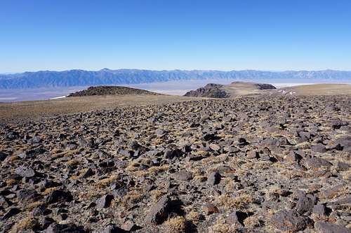
I finally, breathlessly, found level ground. The summit had to be close. Not according to the map though--it said there was another mile-and-a-half or so remaining. The ass kicking continued while my water supply had decreased more. For the first time since clinging to nearly vertical mountainside below Ruby Dome in the middle of the night, a sense of panic crept into my mind. Intermittent breeze blew lightly, and the temperature might've been 40 to 50 degrees or so. Faint, sweet sents of sage were in the mountain air. Yet an irrational feeling that I'd underestimated the mountain washed through me. Looking south, the mountaintop sprawled out as a rolling plateau for miles unlike any I'd seen before. It was beautiful, yet daunting. Despite how clear the sky was, I worried of getting stuck in a storm. Briefuly I prayed an agnostic's prayer.
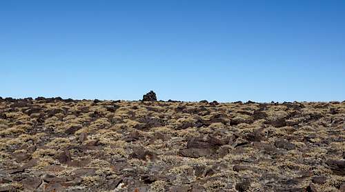
Continuing on, repeatedly encouraging myself, I approached one of the mountain's rocks that had been turned on its side in a cairn-like way. For a moment I thought that was the north summit's cairn. Looking around though, to my left was yet higher ground. As I hiked up the shallow incline, another point appeared on the horizon. It was the cairn I'd been looking for. This was Mt. Jefferson's north summit.
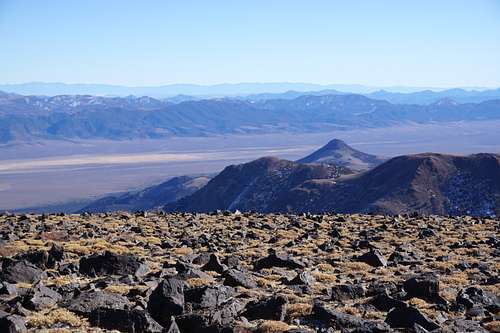
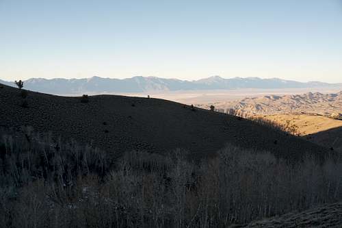
Views were surreal in every direction. The Monitor Range and others beyond were to the east. The Toiyabe Range created a jagged, serrated horizon to the west, and the high point of Arc Dome visibly towered above its surrounding wilderness. The cream-colored alkali flats, dried-up desert lakes, were visible between these two closest ranges. And Mt. Jefferson's massive stature showed itself better than the maps even could.
A section of the Monitor Range to the southeast:
Below, looking nearly due south toward Mt. Jefferson's south summit (11941-ft), slightly higher than the north summit (11814-ft).

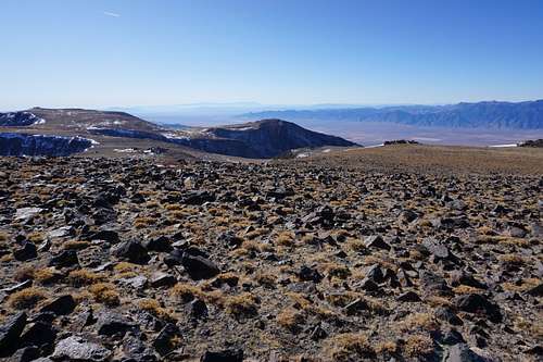
Looking northwest toward the Toiyabe Range. Arc Dome stands high above all as that range's highest point:
Looking southwest toward that section of Mt. Jefferson and the south end of the Toiyabe Range:
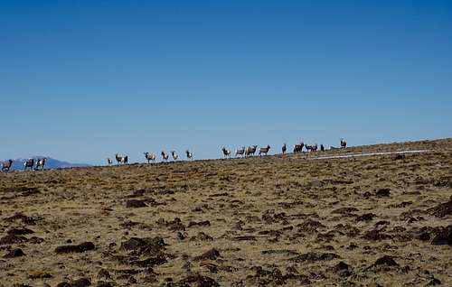
I deemed the south summit to be out of reach at this point mainly due to the dwindling water supply. Traversing to the northwest, to the northwest side of the basin I'd regretted not ascending, I had some minor downhill and then uphill hiking to do. To my surprise and wonder, a herd of at least 35 bighorn sheep lined the shallow ridge that made the basin's edge closest to me. They stared at me for maybe 30 seconds before one of them trotted off to the east. The rest followed suit, though they didn't go far away. Instead they herded more tightly together while watching a lone hiker in a curious, skeptical fashion.

After reaching the area that they'd been before my approach, I inspected the west side of the basin one more time before committing to go all that way. Via my monocular, multiple areas looked inviting for a simple descent. The chosen insertion point onto the mountainside was perhaps a mile from where I stood. I'd go around the rim until it dropped off toward tree-covered slopes.
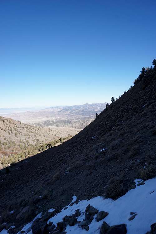
Beginning again, dropping in elevation some more, a breathtaking view stood before me. Expansive alkali flats, reddish-brown desert, and the Toiyabe Range gave a dramatic backdrop to another herd of bighorn sheep that lined this part of tableland that is Mt. Jefferson. Roughly 75 bighorns were in this herd. This, I thought to myself, was Nevada at its finest. Desert bighorns, clear skies, and seemingly plenty of time now.

Unfortunately the bighorns insisted on hurrying down that side of the mountain one after another as I traversed the shallow ridgeline opposite them. I encountered prestine patches of snow a ways off from where they'd been, and I grabbed one. It was a solid chunk, and I carried it while enjoying its snowy taste and hydrating properties. Of course I was hoping that I'd be able to get down a lot easier than going up had been. It was somewhat of a gamble to come all this way without being sure, but after reaching the farthest-northwest side of the mountaintop, it seemed that my judgment had thankfully been sound despite my skepticism. Plenty of trees stood tall on the earth below. The slope looked manageable. I shortened one trekking pole, hovering the other longer one close to the descending terrain, and began sidestepping down the mountain.
In little time, the different type of exertion involved with descending had me taking the coat off and resting again. I continued pondering the somewhat bizarre emotional anguish from earlier. Fortunately it had now vanished. Still, it put a damper on the time earlier, meaning another visit would have to happen with better preparations and planning, and a better idea of what to expect.
Looking northeast during the descent from a section of Mt. Jefferson's northwest end:

At the end of the rest, a zig-zagging pattern of snow seemed to show itself against the brown, rocky surroundings to my right. It was a semblance of a snow-covered, switchbacking trail that I would've found had I descended slightly sooner, slightly south of the present location. It seemed so close, perhaps within only 100 yards, but very rugged terrain separated it from me. Still, I changed my course slightly and worked my way to it. One could argue that descending had ultimately taken longer by chasing the trail instead of by following the trees, but the temptation to see the path was too great. After 30 minutes or so of painstakingly careful movements down chutes between jagged obelisks of reddish-brown rock walls, the terrain leveled out more as I reached the trail. But after all the work getting there, it seemed to cease to exist farther down the mountain. Entering a grove of trees though, I soon enough saw the pink ribbons in the distance.
The far side of this area, the area that I'd chosen to ascend hours earlier, looked perhaps more daunting than it had than when up close.
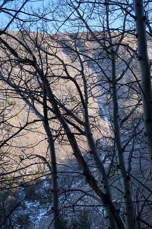
It was impressive getting into the forest and seeing orange-brown aspens with such shiny bark. Some were even approximately 1-ft in diameter.
Dropping down well into the subalpine area, farther toward the ravine, I regained the trail. Crossing the frozen stream, it was nearly all downhill from there. I got a quick picture from the east side of the creekbed as the golden desert sun got lower and lower in the sky.
After another break, the temperature was clearly dropping. But I kept my coat off since I planned to really start descending quickly. Though a ways away, the frozen creek far below in the other small valley was in sight. Soon enough I was essentially jogging down the final slope that led to the creek. This took perhaps 15 minutes. Either way, after no incidents, I sprawled out on the icy creek and enjoyed a snack and almost the rest of my water.
A sense of relief and gratitude came about me that I'd made it back down. It was silent for a time, and with a number of careful steps on and beside the path of ice, only a section of dirt path remained to be hiked. It was a path that I did not find in the morning, and it seemed to be for good reason--its entrace was unmarked and behind tree branches and bushes. But I made a mental note that it's near the only fire pit in the area, approximately 1050 paces away from where I parked, which is the section of the rocky pathway before you'd only want to be on foot or in a type of ATV to go beyond.
Starting the vehicle and getting rehydrated, I saw that the hike had taken right at 12 hours. It would've been a better two-dayer, I thought, with a perfect campsite being somewhere in the basin area near the trees. But still, it was a fulfilling adventure that included many "firsts," such as seeing such a multitude of bighorn sheep, hiking into a research natural area, even simply getting up on top of the mountain. As I drove out of the wild, a golden-blue horizon was shared with the soon-to-be-sleeping mountains of the west. I'd now head farther south to Carvers to enjoy a meatball sub at the fueling station's sub sandwich installation. Maybe after that would be a visit to Manhattan and the Monitor Range just to the east. Or I'd sleep somewhere north closer to Austin. Regardless, I'd seen for the first time a rugged, sacred surface of Nevada that I'd never explored before. And it was one that I'd never forget either.
