
|
|
Mountain/Rock |
|---|---|
|
|
40.77380°N / 110.7521°W |
|
|
12720 ft / 3877 m |
|
|
Overview
Lamotte is an enjoyable climb and backpack in the Uinta Mountains. Though it is the highest peak in the immediate area, it is also the least rugged and easiest to climb. The views of all the rugged surrounding peaks are spectacular from the summit.
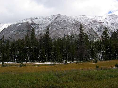
The Uinta Mountains are one of the few mountain ranges in North America that run east to west rather than north to south. Within the Uinta Mountains are about 2000 lakes, and some 900-1000 are full of trout. Along with the San Juan Mountains in Colorado, the Uinta Mountains have more contiguous area above timberline than any other area in the Continental United States.
The Uinta Mountains are very rugged in the northeast section. Beginning at Hayden Peak and east to Mount Lovenia, the Uinta Mountains are not unlike the Tetons or other ranges. East of Lovenia, the peaks are more gentle, with a few rugged peaks (i.e. Red Castle and Henrys Fork Peak) scattered about until you are as far east as the Henrys Fork/Kings Peak area. East of Kings Peak, the Uinta Mountains become very gentle and the peaks are very rounded with only a few scattered cliffs about.
This is a beautiful area with many lakes, meadows, wildflowers, and some rugged peaks. Solitude is usually easy to come by once you leave the popular fishing holes behind.
Utah's 12,000+ Foot Peaks With 200+ Feet Prominence
Utah's 12,000+ Foot Peaks With 300+ Feet Prominence
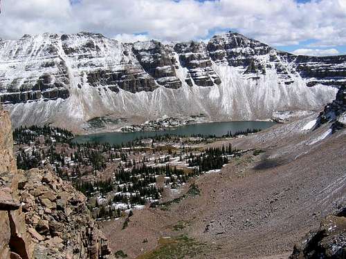 North Ridge of Lamotte Peak from Ostler Peak.
Getting There
Priord Lake Trailhead
First you must drive Highway 150 south from Evanston Wyoming, or east and then north from Kamas Utah. The North Slope (gravel) road heads east from Highway 150 either just south of the Bear River Lodge, or two miles north of the Bear River Visitor Center. After following the North Slope Road for two miles, turn right and follow the main road all the way (don’t turn into the scout camp) to the trailhead. The road is usually a washboard, but any car should be able to make it.
Baker Lake Trailhead
Note: Things have changed since I have been to this trailhead.
Follow the same driving route as above, but do turn right and into the Hinckley Boy Scout Ranch. You may have to park at the gate, but hikers are allowed to walk in. Follow the road past the first camp and to the second. Park or walk to just out side the camp and near the river bridge, especially when the camp is operating Monday though Saturday. The trail is a public access trail (I verified this with the forest service), but don’t park right in the scout camp.
Christmas Meadows Trailhead
This road to the trailhead also leaves from Highway 150. The Christmas Meadows (gravel) Road leaves Highway 150 and heads SE from about 0.7 miles south of the Bear River Visitor Center and right at milepost 46. Follow the gravel road to the trailhead.
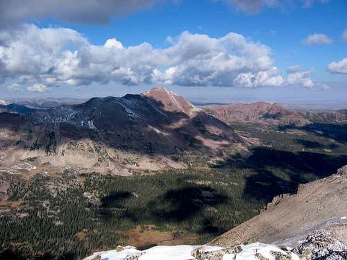 View of Lamotte Peak from the summit of Yard Peak - 10/02/04
Routes Overview
This is meant to be an overview only, so for much more detail, check the route pages.
Priord Lake Route
From the trailhead at 9150 feet elevation, follow the East Fork Bear River Trail east. There is a 4-way trail junction just after the trailhead, but go straight (the trail that crosses this one is the Bear River-Smiths Fork Trail. After 4 miles, you will reach a trail junction. Turn right here on the trail posted for Priord Lake. Follow the trail across the good bridge and along the river up to Norice Lake, which is 4.75 miles from the junction and at 10,450 feet elevation. There are a few stream crossings and the trail is not exactly where the topo maps (Red Knob) show it. Priord Lake is another mile up the bench to the SW. The trail is very faded, but cross-country travel is easy. From Priord Lake, head NW to and up the very steep ridge to the ridge. There is much boulder-hopping and it’s steep, but there are no major problems. One on the ridge simply follow it north to the summit. The summit is about 2 miles from Priord Lake. See the route page for more details.
North Ridge/Baker Lake Route
This is the easiest of the three routes described, but also the least used. Note: As of 2021 the trail to Bker Lake has been mostly abandoned, so the route will be harder than it used to be.
It is a very scenic route as well since it follows a ridge well above timberline for much of the route. From the Hinkley Scout Ranch (8800 feet elevation), locate the Baker Lake Trail. Apparently the old signs are now gone, so you will have to look for the trail. There is a junction after a short distance, but as of the mid 1990’s, it was hard to find and not signposted. The Bear River-Smiths Fork Trail branches to the right, but a tree is blocking the trail and without a signpost, you may miss the junction. Follow the trail/route to Baker Lake. The lake is at 10,420 feet elevation and 4.5 miles from the trailhead. From the lake, route-find to the south via any convenient route. Once above timberline and on the ridge, follow the ridge south all the way to the summit of Lamotte Peak. The distance from Baker Lake to the summit of Lamotte Peak is about 4 miles, making the total distance from the trailhead 9.5 miles with about 4000 feet elevation gain. See the route page for more details.
Note: My info is out of date for this route, especially concerning the trail to Baker Lake, so any updates are appreciated.
 Lamotte from the North Ridge Route.
Christmas Meadows/Stillwater Fork Route
This is the most difficult of the three routes to Lamotte Peak because of steep and loose rock. It is also the most popular route. From the trailhead at 8800 feet elevation, follow the trail south up Stillwater Fork. The trail is heavily used and is at a gentle grade until reaching a junction after 2.6 miles. Turn left here at the trail posted for Amethyst Lake. Follow the trail for two miles until you reach a meadow due west of the summit of Lamotte Peak. From the meadow, climb the extremely steep slope east to the summit. The distance from the meadow to the summit is only a mile, but with almost 2700 feet altitude gain. The total distance from the trailhead to the summit is only 5.6 miles, but it seems much longer. See the route page for more details.
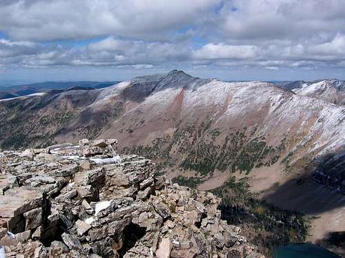 Lamotte Peak as viewed from the summit of Ostler Peak. West face is center and north ridge to the left.
Red Tape
No permits are required.
When To Climb
Mid-July through Mid-September is the normal hiking/climbing season. In winter, the North Ridge is the best bet, but the road isn't open all the way to the trailhead.
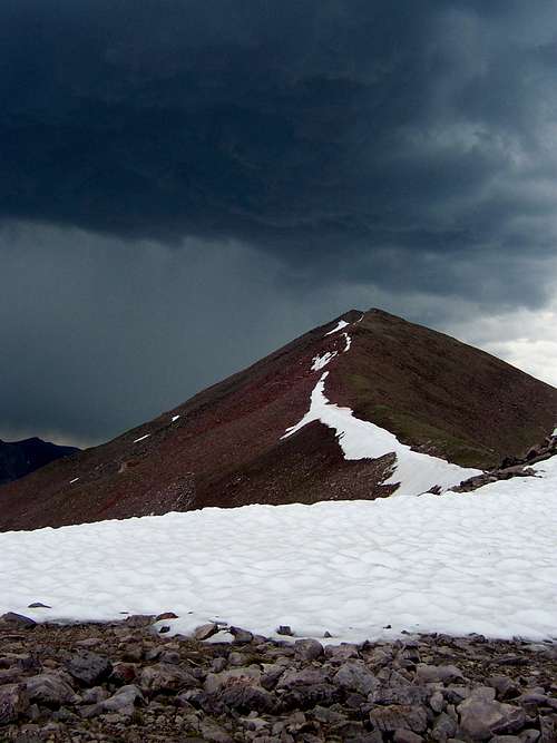
 The north ridge in mid-April.
Camping
There is a campground at the Christmas Meadows trailhead as well as infomal campsites along the road to the other trailheads. Backcountry campsites are plenitiful along all routes up to the timberline.
 Early October on Lamotte Peak. Good Campsites are easy to find.
Time Needed for Climb
Most people will want three days for the hike/climb. A very fast and strong hiker could do it in two days.
Mountain Conditions
Contact the ranger station in Kamas for current road and trail conditions. Their phone number is 801-783-4338.
Weather Forecast for Central Uinta Mountains
Here are some average highs and lows from the 13,123 foot elevation (4000 meters) in the Uintas (about the same altitude as the summit):
| MONTH | HIGH | LOW |
| JAN | 11 | -4 |
| FEB | 13 | -2 |
| MAR | 16 | 1 |
| APR | 24 | 8 |
| MAY | 32 | 15 |
| JUN | 42 | 22 |
| JUL | 52 | 29 |
| AUG | 50 | 28 |
| SEP | 42 | 21 |
| OCT | 31 | 12 |
| NOV | 19 | 5 |
| DEC | 14 | 0 |