

-
 29917 Hits
-
 89.39% Score
-
 29 Votes
|
|
Hut/Campground |
|---|---|
|
|
45.91394°N / 7.85795°E |
|
|
Monte Rosa |
|
|
Spring, Summer, Winter |
|
|
13671 ft / 4167 m |
Bivacco Felice Giordano general information
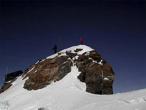
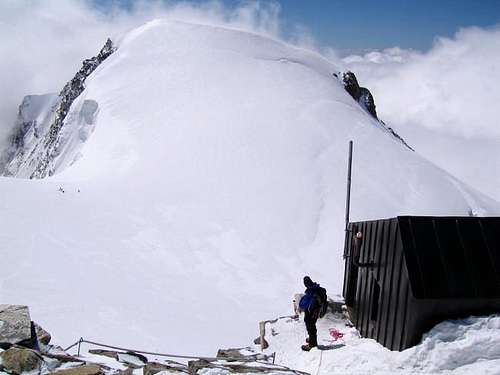
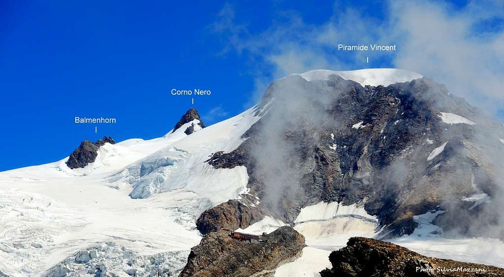
The Bivacco Felice Giordano is a bivouac located a few meters below the summit of the Balmenhorn 4167 m, in the municipality of Gressoney-La-Trinité, Valle del Lys, in the Aosta province. The Balmenhorn is a very tiny peak of the Monte Rosa group, although it is higher than for example the famous Aiguille Verte, the Jungfrau or the Breithorn. Because it is more than 4000 m high, it is interesting for those people who collect 4000m-peaks. Anyhow Balmenhorn it is not included in the official list of the 82 Four-thousanders. It belongs to the Monte Rosa massif. The Balmenhorn has a rock summit and is situated southwestern of the Corno Nero on the Lysglacier, on the orographically left side of the Lysglacier. The highest point has a Christ statue "Christo delle Vette" which is higher than a normal person. It is made out of bronze. It was created by Alfredo Bai on the 4th of September 1995.
The Bivacco Felice Giordano is reached along the route to the Lys Col running on the Lys glacier across the Rifugio Città di Mantova and Rifugio Giovanni Gnifetti, which is the first part of the extremely popular Punta Gnifetti Normal route. It can serve as a base for the mountaineering and ski mountaineering ascent of this group of peaks of Monte Rosa from the Italian side. It can be useful as an emergency shelter. In summer it is often overcrowded.
History
The bivouac was built a few meters below the summit of Punta Balmenhorn during the First World War. In 1955 the statue of Cristo delle Vette was erected on the top.
The current bivouac, which replaced the old one, was placed in 1985 and dedicated to Felice Giordano, mountain guide of Valsesia, who died in 1968 falling into a crevasse near the Pyramid Vincent during a rescue operation.
How to get there
Two different approachs roads are possible depending if coming from the Valle di Gressoney (Aosta) or from the Val Sesia (Piemonte).
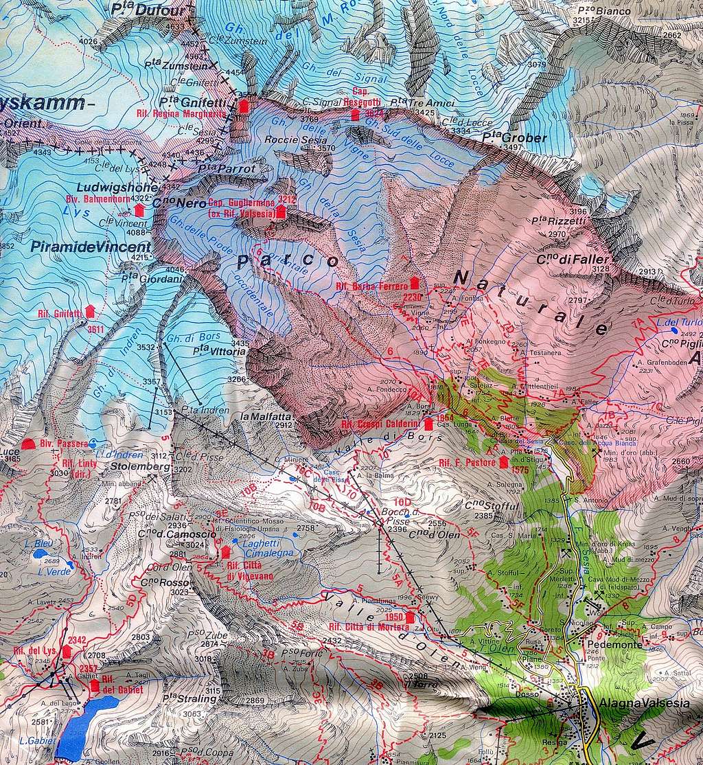
Access via the Valle di Gressoney (Aosta Valley) - From the A5 Torino – Aosta Highway, exit Pont St. Martin and take the Valle di Gressoney, getting to Gressoney St. Jean, Gressoney La Trinité and Staffal. From Staffal take the cableway to Alpe Gabiet – Passo dei Salati - Indren glacier. The first cableway brings to the middle station of Alpe Gabiet (there is a bar- restaurant called Rifugio Lys) a few minutes from the Gabiet Lake. The second cableway brings to Passo dei Salati, where you can find the new lift to Punta Indren 3250 m. From Indren it starts the walk. From the lift, follow the track crossing the glacier and in about 20 minutes you reach a fork, a low and a high track. Follow the low one until the end of the glacier. Go beyond a rock with fixed ropes (15 meters), than climb up again and shortly the Refuge Mantova hut is reached. It takes about 1 hour from the lift-station to the hut. If you choose the high track where the snow ends it begins a mixed path (rocks and snow) and after a few bends you reach an equipped path. When you reach the topo of this path you see on the left, below, the Refuge Mantova. The time required is about 1 hour. To reach the Capanna Gnifetti from the Mantova Hut you have to cross the Garstelet glacier. This will take up to 30 minutes longer. For information about the cableway from Gressoney to Indren (including prices, timetable) see here: Gressoney cableway.
Access via the Val Sesia (Piemonte) - From the A26 Highway exit to Romagnano Sesia and take the road to Varallo Sesia. Here continue following all the Val Sesia road to Alagna Valsesia. From Alagna Valsesia take the skilifts in three sections: Telecabina Alagna-Pianalunga - Funifor Pianalunga-Passo dei Salati – Funifor Passo dei Salati-Indren. Info here: Alagna Valsesia cableway.

Alagna Valsesia and Gressoney skilifts map
Alternatively by walk (no cable car) it will take 6 h from Alagna
Get to Punta Indren on the marked hiking path n. 5 from Alagna via Dosso (1357m). You go to the Alpe Oltu (1847m, cable car station, 1,5 h) and furth up the Valle d'Olen. You go along the Sasso del Diavolo and reach almost Colle d'Olen, where you turn right to the Vigevano-hut (3 h). You go further along Passo Salati (2936m) to the ridge-crest and traverse Stolemberg. On the side of the Indrenglacier, you reach the station (1 1/4 h, totally 6 h).
From Switzerland
You reach Alagna by car on the road E62 from Brig via Simplonpass. Turn off at Ornavasso (near Lago Maggiore) and drive to Omegna. Here turn right and drive along the western side of Lago Orta to Borgosésia. In Borgosésia you take the road to the N an reach Alagna via Varallo and Scopello. You can reach Aosta through the Great St.Bernard Tunnel or the Great St.Bernard Col, then from Aosta reach Pont St. Martin and here take the road running in Val Gressoney to Staffal.
Approach from Punta Indren
Easy glacierroute, also possible as skitour
Get to the refuges Mantova and Gnifetti from Punta Indren, 3260 m (cable car from Alagna or Gressoney) in 1,5 h via the Rif. Città di Mantova, 1 h to Rif. Città di Mantova. In the lower part, it is a marked path (n. 5). The traverse of the glacier is not marked.
From Punta Indren, traverse the ski-run, slowly going up on the Indrenglacier till you reach the outstanding rock band above which the Mantova-hut is situated (yellow-red signs). You climb up the rock steps (fixed ropes). To reach the Gnifetti Hut from the Mantova Hut you have to cross the glacier going up over the E-side of the glacier to the N and at the end on the rocks to the Gnifetti hut. This will take up to 30 minutes longer.
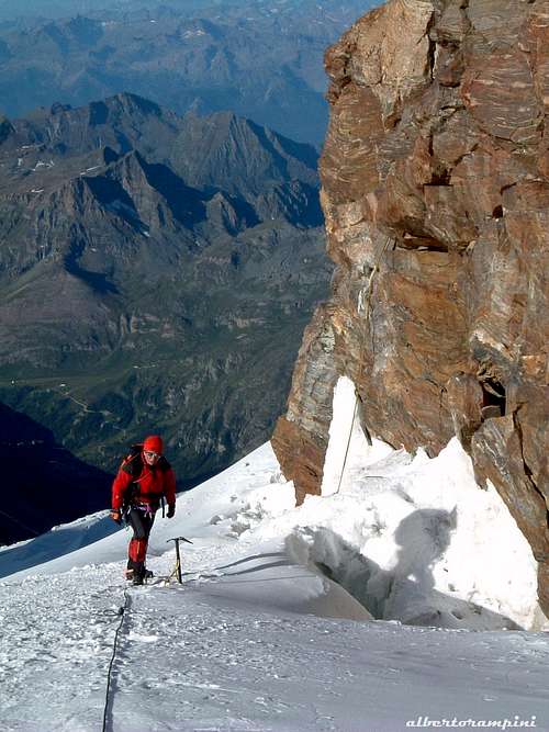
From the Refuge Gnifetti enter the glacier and follow it at first diagonally to the left (toward North-East) along a steep ramp, then toward North rising on moderate ice-slopes, never too away from the steep slopes of Vincent. In some sections the route presents a few passages between wide crevasses. Continue always along the track, usually present in summer, heading to the Lys Col.
The Balmenhorn is reached very easily in 2 hours from the Rif. Gnifetti when you go to the Lysjoch.
Accomodation
- Rifugio Città di Mantova m. 3470
Situation: Garstelet Glacier
Open: from June to September
Size: 85 persons + 15 in the winter-shelter
Guardian: Guide di Gressoney
Hut's phone : 0039 0163 78150 / 347 0802910 Email: info@rifugiomantova.it
Situation: rockspur between the Lysglacier and the Garsteletglacier
Open: spring from middle March to middle May - summer from middle June to middle September
Size: 176 persons + 4 in the winter-shelter
Hut phone : 0163 78150 / 347 0802910 Email: info@rifugimonterosa.it
Red Tape
No fees no permits required
When To Climb
Summer and winter (ski)
Meteo
Meteo Valle d'Aosta
Meteo Piemonte
MeteoSwitzerland
General Information
Guidebooks and Maps
Schweizer Landeskarten: 1:25000 no. 1348 Zermatt
Matterhorn-Mischabel n. 5006 1:50000
Mischabel n. 284 1.50000
Gressoney n. 294 1:50000
Books
Hermann Biner, Hochtouren im Wallis. Vom Trient zum Nufenenpass. 2nd ed. 1996.
ISBN 3-859022-160-5
Helmut Dumler/Willi P. Burkhardt, The High Mountains of the Alps. 1994.
(to order at amazon.com)
ISBN 0898863783
Helmut Dumler/Willi P. Burkhardt, Viertausender der Alpen. 11th ed. Munich 1998.
ISBN 3-7633-7427-2 Michael Waeber, Walliser Alpen. DAV-Gebietsführer. 12th ed. Munich 1999.
ISBN 3-7633-2416-X Michel Vaucher, Walliser Alpen. Die 100 schönsten Touren. 2nd ed. Munich 1990.
External Links
Balmenhorn at www.4000er.de
Images, routes, coordinates and more information about the highest peaks of the Alps
Dedication
This page will be kept in honour of the SP member Rahel Maria Liu, the former owner of this page, who died for hypotermia on 24/25 August 2004 after being caught in a snowstorm on the Innominata Spur on the southern (Italian) face of Mont Blanc. Edward Allen, her climbing companion, was saved by an helicopter of the Italian Rescue team.