
|
|
Mountain/Rock |
|---|---|
|
|
15.13443°N / 120.35230°E |
|
|
Hiking, Trad Climbing, Toprope, Scrambling |
|
|
Spring, Summer, Fall, Winter |
|
|
4875 ft / 1486 m |
|
|
Overview
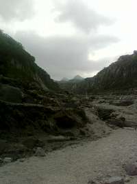
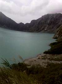
Mount Pinatubo is an active volcano located on the island of Luzon in the Philippines, at the intersection of the provinces of Zambales, Tarlac, and Pampanga. The mountain iss inconspicuous and heavily eroded. It is covered in dense forest which supports a population of indigenous people, the Aeta, who had fled to the mountains from the lowlands when the Spanish conquered the Philippines in 1565.The volcano's eruption in June 1991 came after 600 years of dormancy, and produced one of the largest and most violent eruptions of the 20th century(as seen on the cover of National Geographic Magazine). Predictions of the climatic eruption led to the evacuation of tens of thousands of people from the surrounding areas, saving many lives, but as the surrounding areas were severely damaged by pyroclastic flows, ash deposits, and later, lahars caused by rainwater remobilising earlier volcanic deposits, thousands of houses were destroyed.
The effects of the eruption were felt worldwide. It injected large amounts of aerosols into the stratosphere—more than any eruption since that of Krakatoa in 1883. Over the following months, the aerosols formed a global layer of sulfuric acid haze. Global temperatures dropped by about 0.5 °C (0.9 °F), and ozone destruction increased substantially.
Getting There
From Manila, plan on a 2-3 hour drive Northwest.
~1 hour jeep ride across ash, salt flats, and thru tributaries of the Pasig River to a hidden entrance. Then a 3 hour hiking ascent; mod-easy trek up pyroclastic river basin into the jungle.
Red Tape
Minimal; the PI Air Force runs the park and are quite friendly at the entrances. Land fee (if charged) is below 500 pesos.Camping
Hotels are available all along the road North out of Manila.
External Links
USGS MAPShttp://vulcan.wr.usgs.gov/Volcanoes/Philippines/Pinatubo/framework.html
Mt. Pinatubo (Wikipedia)
http://en.wikipedia.org/wiki/Pinatubo
Mt. Pinatubo (Stratovolcano)
http://www.ngdc.noaa.gov/seg/hazard/stratoguide/pinfact.html
akirmse - Oct 21, 2014 1:08 am - Hasn't voted
Lat/LngThe coordinates of this mountain are pretty far off. Can they be corrected please? 15.141667, 120.35