-
 42084 Hits
-
 91.69% Score
-
 36 Votes
|
|
Area/Range |
|---|---|
|
|
46.65100°N / 12.64660°E |
|
|
9121 ft / 2780 m |
|
|
Overview
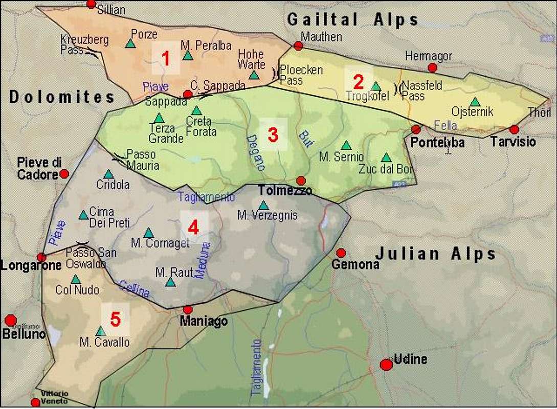
The best known of the subgroups of the Carnic Alps is the Main Ridge, especially its western part between Kreuzbergpass / Passo di Monte Croce and Plöckenpass / Passo di Monte Croce Carnico. The popularity can partly be explained by the proximity of the Sexten Dolomites / Dolomiti di Sesto, probably the most beautiful of the Dolomite Groups, drawing the attention of thousands of hikers and climbers each year. Many of them take the cablecar to Helm / Monte Elmo, the westernmost mountain of the Carnic Alps, to get an overview of the many subgroups of the Sexten Dolomites.
It would be unfair, however, to see the Carnic Alps Main Ridge only in the light of its views towards Sexten. It is a very impressive hiking and climbing destination in itself. For the hikers a long trekking trail has been established in the 70s of the last century. "Karnischer Höhenweg" runs along to the north of the Main ridge, often (rather mostly) using trails, which had been established during World War I. In that war, 90 years ago, the main ridge was a fiercely contested battleground between the Austrian Kaiserjäger and the Italian Alpini. Many caves, buildings and trenches still document this part of history.
The geology of the area is very complex. For an overview, see the relevant section on the Carnic Alps Page. For a short abstract let it be said that to the north of the ridge the peradriatic fault between the North-African and European tectonic plates runs through Lesachtal Valley and that the region was at the centre of the action during the formation of the Alps. So smooth mountains formed out of eruptive rocks (mostly black lava) abruptly change into white limestone formations of almost Dolomite like quality. It is these latter vertical rocks, which are well known climbing destinations. Since they are not as crowded as similar mountains in the Dolomites you can find relaxed climbing of good quality.
The area covered in this page not only deals with the main ridge. To the north there are a number of side ridges which offer good hiking onto great lookout summits. In most cases it is possible to start from one northern valley towards the main ridge, hike or climb along that ridge and return through the next valley, all in one day. To the south there are three large subgroups which could be dealt with separately but which usually are considered to belong to the Main Ridge. These are Crode dei Longerin, Monte Peralba and Monte Rinaldo. A similar isolated group exists to the north - Mooskofel Group.
The subdivision closely follows the system proposed by the German Alpine Club - see the book by P. Holl (in the "Maps 'n' Books" Section below). Only the first subgroup has been "created" by me to prevent a group getting too large. Also there is a distinctive change of character of the main ridge between Pfannspitze and Kleine Kinigat which justifies the division in my eyes.
The western part of the Carnic Alps Main Ridge will be divided into:
- Western Main Ridge – Helm through Pfannspitze
- West Central Main Ridge – Kleine Kinigat through Weißsteinspitze
- Crode dei Longerin Group
- Peralba – Chiadenis – Avanza Group
- East Central Main Ridge – Raudenspitze through Kreuzleithöhe
- Biegengebirge
- Kellerwand - Hohe Warte Group
- Mooskofel Group
- Rinaldo Group
Names: since the Carnic Alps Main Ridge is the border between Austria and Italy many of the mountains have double names. In most cases one name is used in both countries regardless of the language (with the second name only a historical addendum). Often the names were literally translated into the other language. In the listings I placed the common names first. The German names are far from unique either. Most summits ending on -egg can also be spelled -eck. In some cases the Austrian dialect deletes vowels (Liköflwand instead of Liköfelwand). I used the German letters ä, ö, ü and ß, which can also be written ae, oe, ue and ss.
1 - Western Main Ridge - Helm through Pfannspitze
This first subgroup is characterized by a large number of summits which almost reach the same height and which are rather unspectacular. Most are easy hiking targets, only Wilde Karlesspitzen, Wiederschwing and Tscharrespitze in the northern side ridges are real climbing summits.
Main ridge:
- Helm / Monte Elmo (2433m)
- Füllhorn / Corno Copia (2445m)
- Hochgruben / Tova Alto (2537m)
- Hornischegg / Monte Arnese (2551m)
- Hollbrucker Spitze (2581m)
- Pfandlegg (2381m)
- Demut / La Mutta (2591m)
- Roteck / Monte Rosso (2390m)
- Schöntalhöhe (2636m)
- Eisenreich
- Hollbrucker Eisenreich (2649m)
- Schuster Eisenreich (2665m)
- Winkler Eisenreich (2630m)
- Hollbrucker Eisenreich (2649m)
- Cima Frugnoni (2561m)
- Pfannspitze / Cima Vanscuro (2678m)
1st northern side ridge (starting from Hollbrucker Spitze):
- Hollbrucker Eck (2573m)
- Wilde Karlesspitzen (3496m)
- Zenzerspitze (2393m)
- Scheibenegg (2269m)
2nd northern side ridge (starting from Demutspitze):
- Wiederschwing (2388m)
- Weißer Knoten (2202m)
- Schusteregg (2032m)
3rd northern side ridge (starting from Eisenreich):
- Tscharrespitze (2499m)
- Gatterspitze (2430m)
4th northern side ridge (starting from Pfannspitze):
- Roßkopf (2603m)
- Maurerspitze (2549m)
- Fällkofel (2223m)
- Nöck (2142m)
1st southern side ridge (starting from Cima Frugnoni):
- Punta Silvella (2329m)
- Col Quaterna / Knieberg (2503m)
- Col Rosson (2304m)
- Monte Spina (1966m)
2 - West Central Main Ridge - Kleine Kinigat through Weißsteinspitze
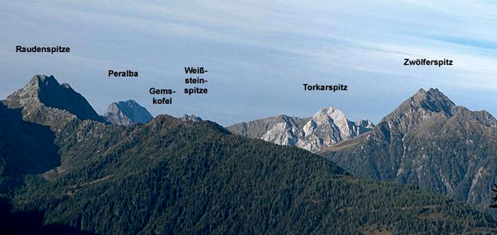

In this part the true characteristics of the Carnic Alps can beautifully be seen. Rocks change from black volcanic rock to white limestone with some red porphyry stretches in between. In these parts there are many serious climbing destinations (Roßkopf, the Kinigats, Liköfelwand and Porze).
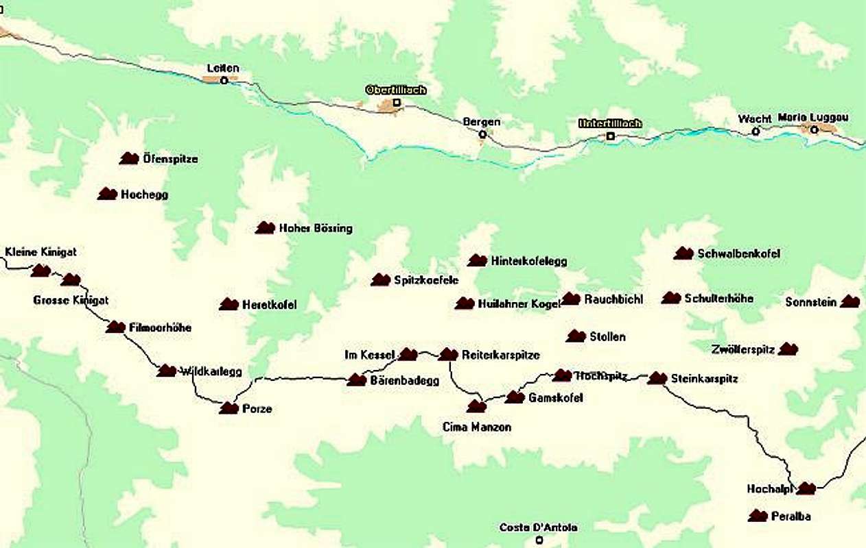
Main ridge:
- Kleine Kinigat / Monte Cavalatto (2671m)
See the Kleine Kinigat page
- Große Kinigat / Monte Cavallino (2689m)
Great for hiking and climbing. See the Große Kinigat Page
- Königswand (2686)
In the Italian literature Königswand is considered one mountain together with Große Kinigat: Monte Cavallino
- Königswandtürml (2636)
Impressive tower to the south of Große Kinigat. Interesting climbing routes
- Filmoorhöhe / La Pitturina (2457m)
Interesting destination of a difficult ferrata / Klettersteig.
- Wildkarleck / Cima Vallone (2532m)
- Roßkarspitze / Col dell'Ai (2511m)
- Porze / Cima Palombino (2589m)
Massive, castle like mountain with two ferrate and a couple of interesting climbing routes. See the Porze Page.
- Bärenbadegg / Croda Nera (2430m)
- Stollen, also Im Kessel / Col del Rocco (2370m)
- Reiterkarspitz / Monte Cecido (2421m)
- Cima Manzon (2328m)
- Gamskofel / Cima Mezzana (2415m)
- Hochspitz / Monte Vancomun (2581m)
- Steinkarspitze / Monte Antola (2524m)
- Weiße Lungern (2486m)
- Torkarspitze / Monte Pietra Blanca (2513m)
- Weißsteinspitze, also Hochalplspitze / Monte Tap (2462m)
See the Weißsteinspitze Page for more information
- Hochalpl / Monte Oregone (2345m)
Easy hiking summit, which is crisscrossed by trenches of WW I. Nevertheless one of the most interesting and difficult climbing destinations of the Carnic Alps. Four routes between VI- and VIII on the north-eastern face. See the Hochalpl Page for more information.
- Tscharreknollen (2482m)
- Resler Knollen (2306m)
- Liköfelwand (2380m, 2427m, 2465m)
Well known climbing destination with lots of routes with 200 - 300m length
- Hocheck (2477m)
- Öfenspitz (2334m)
- Spitzeck (2229m)
- Heretkofel (2438m)
- Hoher Bösring (2324m)
- Zwiesel (2089m)
- Zwieselegg (2111m)
- Kesselhöhe (2375m)
- Spitzköfele (2314m)
See the Spitzköfele page
- Huilahner Kogel (2230 m)
- Hinterkofelegg (2117m)
- Stollen (2330 m)
- Rauchbichl (2180m)
- Zehrer Höhe (2460 m)
- Schulterhöhe (2424m)
See the Schulterhöhe page for more information.
- Schwalbenkofel (2158m)
- Weidenkopf (2405 m)
- Zwölferspitz (2592m)
Three peaked summit dominating the central part of the Carnic Alps Main Ridge. See the upcoming Zwölferspitz page
- Spitzkofel (2450m)
- Sonnstein (2290m)
3 - Crode dei Longerin Group
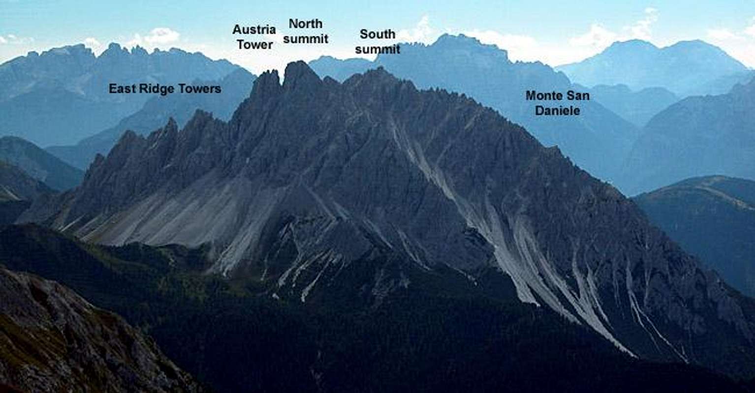
This is a smallish subgroup located to the south of the Carnic Alps Main Ridge on Italian territory. An interesting climbing destination, especially near the twin peaked summit of Crode dei Longerin and its East Ridge Towers.
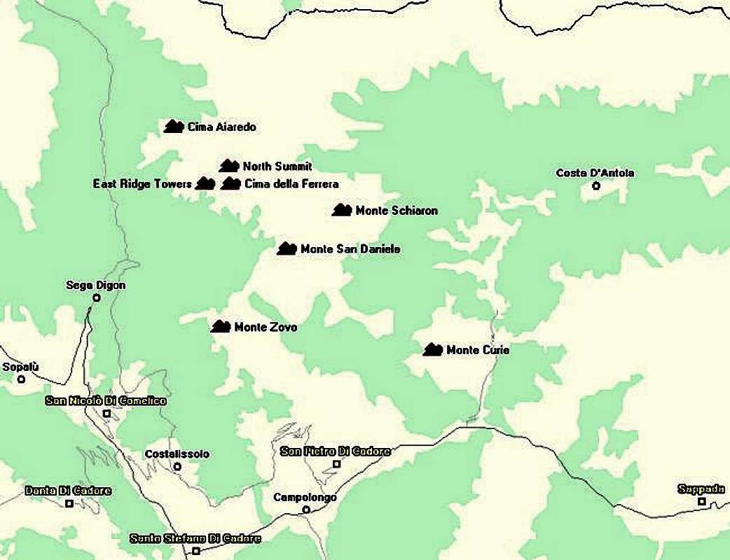
- Crode dei Longerin - north summit (2571m)
- East Ridge Towers
- 1st Tower (2270m)
- 2nd Tower / Torre Ezio Culino (2328m)
- Small tower / Torre Piccolo (2250m)
- 3rd Tower (2300m)
- 4th Tower (2340m)
- Ago Vissada / Vissada Needle (2300m)
- 5th Tower / Torre Londo (2330m)
- 6th Tower / Torre Pia (2412m)
- 7th Tower / Austriaturm (2500m)
- 1st Tower (2270m)
- Crode dei Longerin - south summit / Cima della Ferrera (2523m)
- Monte Zovo (1937m)
- Cima Aiaredo (1922m)
- Monte Schiaron (2246m)
- Monte Curie (2035m)
4 - Peralba - Chiadenis - Avanza Group
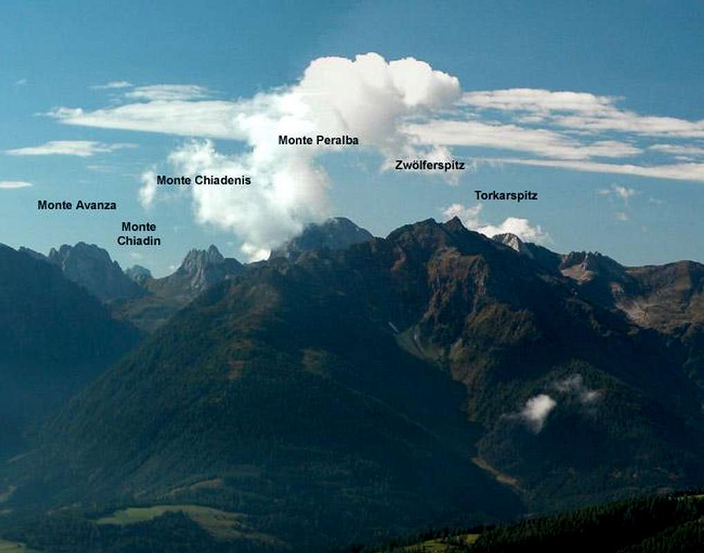
This subgroup is also located to the south of the main ridge. It is clearly dominated by the broad summit of Monte Peralba. All summits are very interesting climbing locations though the normal ascents can be done by an average hiker.
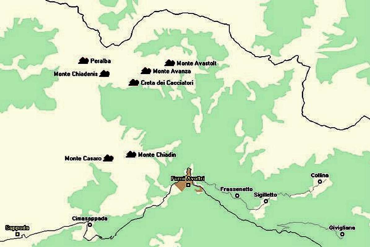
- Monte Peralba / Hochweißstein (2694m)
See the Peralba page for more info.
- Monte Chiadenis
- Main summit (2490m)
- Southern summit (2459m)
Many routes on both summits.
- Main summit (2490m)
- Creta dei Cacciatori / Jägerkamm
- Western summit (2367m)
- Eastern summit (2433m)
- Western summit (2367m)
- Campanili delle Genziane / Enziantürme
- 1st Gentian Tower (2300m)
- 2nd Gentian Tower (2240m)
- 3rd Gentian Tower (2180m)
- 4th Gentian Tower (2160m)
- 1st Gentian Tower (2300m)
- Cima delle Batterie (2430m)
- Monte Avanza (2481m)
- Cima della Mineria (2462m)
- Crassigne dal Cramar
- Western Avanza Tower / Torre Ovest della Crassigne dal Cramar (2265m)
- Eastern Avanza Tower / Torre Est della Crassigne dal Cramar (2265m)
- Torre Buso (2050m)
- Monte Avastolt (also Navastolt, Punta Avoltri, 2321m)
- Monte Casaro (2105m)
- Monte Chiadin / Käserkofel (2269m)
- Monte Chiaine (1784m)
5 - East Central Main Ridge - Raudenspitze through Kreuzleithöhe
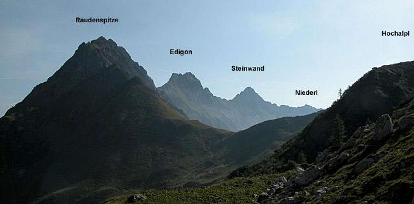
The area between Peralba and Biegengebirge is a very lonely region. The hiking trails run far to the north or south of the ridge since the terrain is very difficult. There is a ferrata traverse of the western half of this subgroup, great for views but very exposed. All summits along that ferrata are rather difficult to climb (from a hiker's point of view).
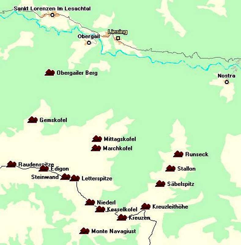
Main Ridge
- Raudenspitze (also western Raudenspitze) / Monte Fleons (2507m)
- Edigon (also Schönleitenschneid, eastern Raudenspitze, 2511m)
- Steinwand / Creta Verde (2520m)
Huge north face
- Letterspitze / Cima Letter (2463m)
- Niederl (2232m)
- Kesselkofel / Monte Chiastronat (2251m)
- Kreuzen / Creta di Bordaglia (2175m)
- Kreuzleithöhe (2160m)
- Gemskofel (2115m)
- Obergailer Berg
- Wasserköpfe (2264m)
- Marchkofel (2300m)
- Mittagskofel (2251m)
See the Mittagskofel Page
- Säbelspitz (2159m)
- Stallon (2162m)
- Runseck (2144m)
For the whole ridge see the upcoming Säbelspitz / Stallon / Runseck page
- Monte Navagiust (2129m)
6 - Biegengebirge

The German name "Biege" means bend and this part of the Carnic Alps Main Ridge first runs north to south before it bends to the east again. All mountains are beautiful limestone summits with impressive north and east faces.The best location to view the bend is on Mahderkof, which is located at the "focal point" of the bend. Rauchkofel to the east, where I took the overview picture is another great viewing location.

Biegengebirge
- Biegenköpfe
- Northern Biegenkopf (2166m)
- Central Biegenkopf (2247m)
- Southern Biegenkopf (2364m)
- Northern Biegenkopf (2166m)
- Wolayer Kopf / Monte Volaia (2470m)
- Cima di Sasso Nero (2468m)
- Cresta di Chianaletta / Chianalettagrat
- 1st Tower / East Tower (2451m)
- 2nd Tower / Main Tower / Slezak Tower (2472m)
- 3rd Tower / Mucha Tower
- 4th Tower / Kaser Tower (2382m)
- 5th Tower / Weigend Tower
- 1st Tower / East Tower (2451m)
- Monte Canale (2540m)
- Wolayer Seekopf / Monte Capolago (2554m)
- Cima d'Ombladeet (2255m)
7 - Kellerwand - Hohe Warte Group

Hohe Warte / Monte Coglians ist he highest mountain of the Carnic Alps. The surrounding summits almost reach the same altitude so that the Kellerwand - Hohe Warte Group is certainly the most impressive of the whole mountain range. With Eiskar Glacier the groups has the lowest altitude glacier of the Alps at 2200m. The glaciear is fed by avalanches and its location on the northern flanks of Kellerwand ensures that it never sees the light of the sun.

Hohe Warte Ridge
- Seewarte / Cima Lastrons del Lago (2595m)
- Hohe Warte / Monte Coglians (2780m)
Highest summit of the Carnic Alps, covered on the Hohe Warte page
- Costone di Stella (2607m)
- Kellerwarte / Cima di Mezzo (2713m)
- Kellerwandturm (2718m)
- Kellerspitzen / Creta delle Chianevate (2769m)
- Kollinkofel / Pizzo Collina (2691m)
- Cellon / Frischekofel (2238m)
- Creta Monumenz (2488m)
- Pic Chiadin (2307m)
- Monte Floriz (2184m)
- Cima Pletta (2017m)
- Monte Crostis (2250m)
- Monte Neval (2061m)
- Monte Pezzacul (2176m)
- Piz di Mede (2094m)
- Monte Valsecca (1966m)
- Cimone di Crasulina (2104m)
- Monte Terzo (2034m)
- Zoufplan (1999m)
- Monte Tenchia (1840m)
- Kunzköpfe
- South-west summit (2291m)
- North-east summit (2270m)
- South-west summit (2291m)
- Eiskarkopf (2269m)
- Gabelkopf (also Grüne Nase, 2289m)
8 - Mooskofel Group
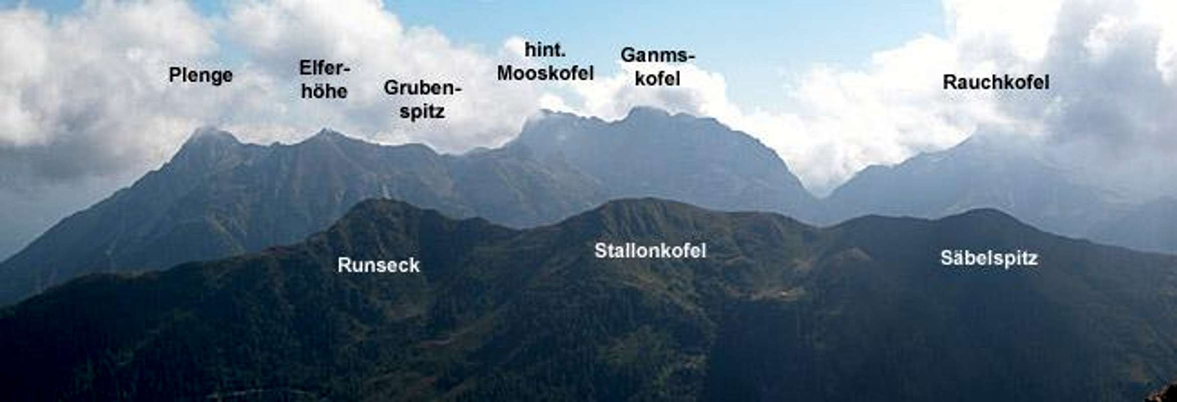
Geologically, this is the most complex of all the Carnic Alps Subgroups. As you can see from the Geology Section of the Carnic Alps page, the area was on the frontline during the build-up of the Alps. "Mountain Folding" occurred in waves which often overtook each other. Thus the layering often shows new layers sandwiched between old ones, or same age layers distributed over a complete face with younger ones interspersed. Mooskofel, though of minor climbing importance, is a Mecca for geologists.
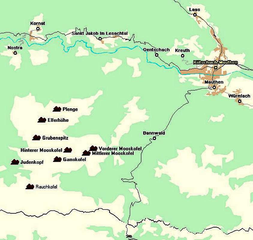
Mooskofel Group
- Rauchkofel
- Western summit (2436m)
- Eastern summit (2460m)
Wait for the upcoming Rauchkofel page.
- Western summit (2436m)
- Mahderkopf (2155m)
- Judenkopf (1833m)
- Grubenspitz (2305m)
- Plenge (2372m)
- Gamskofel (2526m)
- Hinterer Mooskofel (2510m)
- Mooskofelturm (2364m)
- Mittlerer Mooskofel (2359m)
- Vorderer Mooskofel (2284m)
9 - Rinaldo Group

The subgroup is located to the south of Peralba but still north of the Piave River. It has some importance in climbing circles but is far less known (and important) than the Peralba - Chiadenis - Avanza Group.
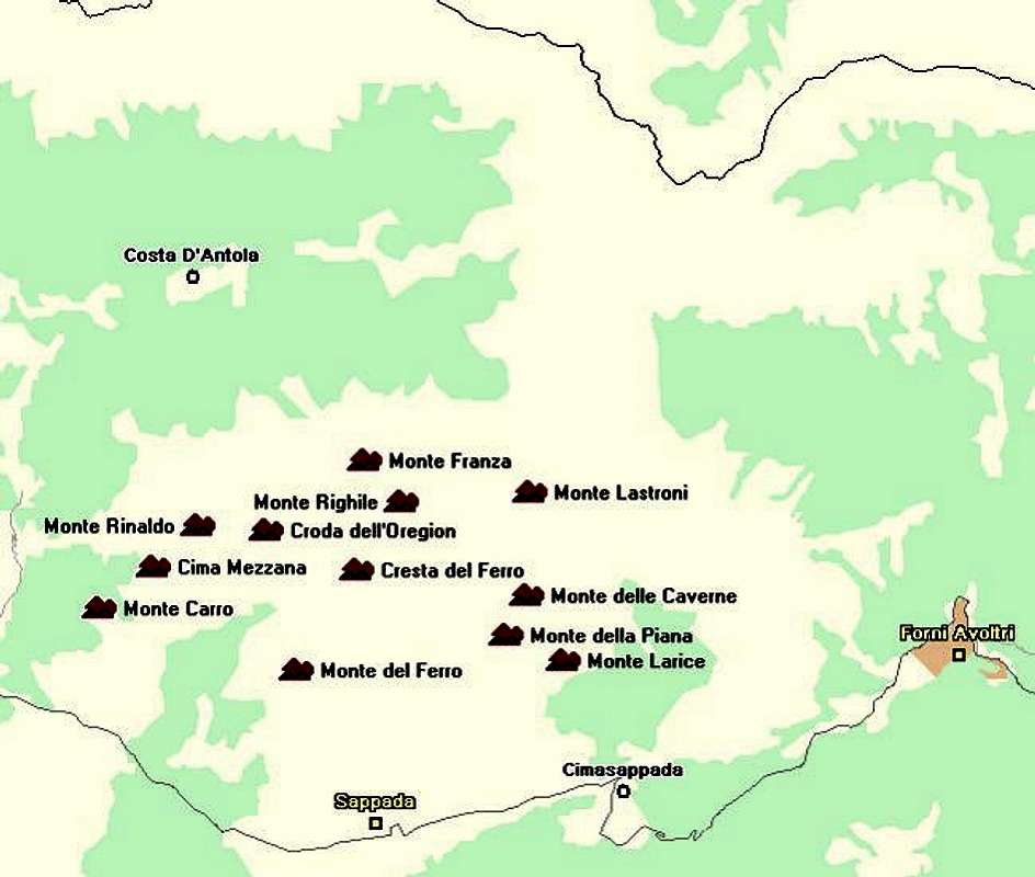
- Monte Carro (2136m)
- Cima Mezzana (2249m)
- Monte Rinaldo (2473m)
- Croda dell'Oregion / Croda dell'Oregone (2429m)
- Campanile Luisa (2420m)
- Campanile Visdende (2416m)
- Campanile Brunner / Campanile Innominato (2410m)
- Schartenturm / Torrione Senza Nome (2350m)
- Reichensteinturm / Campanile di Val Popera (2390m)
- Torrioni Berti (2450m)
- Monte Franza (2329m)
- Monte Righile (2467m)
- Cresta del Ferro / Cresta Righile (2400m)
- Monte del Ferro / Eisenberg (2348m)
- Torre di Mezzogiorno (2300m)
- Monte Lastroni (2449m)
- Monte delle Caverne (2073m)
- Monte della Piana / Monte Piano / Flächkofel (2162m)
- Monte del Larice (2025m)
Getting There
