
-
 8532 Hits
-
 88.19% Score
-
 26 Votes
|
|
Area/Range |
|---|---|
|
|
45.94014°N / 10.69616°E |
|
|
Hiking, Mountaineering, Trad Climbing, Sport Climbing, Ice Climbing, Scrambling, Via Ferrata, Skiing |
|
|
Spring, Summer, Fall, Winter |
|
|
7395 ft / 2254 m |
|
|
What's new on this page?
PAGINA COMPLETATA CON TRADUZIONE IN LINGUA ITALIANA - THE ITALIAN TRANSLATION ADDED TO THE PAGE (2021, February)
Overview
Prealpi Bresciane e Gardesane
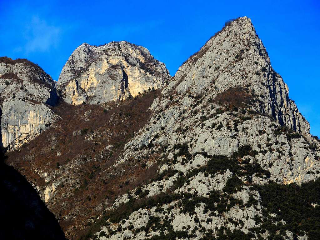
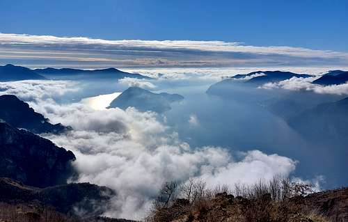
The Prealpi Bresciane e Gardesane belong to the South-Eastern Alps and are located between Lago di Iseo and Alpi Orobie to the West and Lago di Garda to the East. Their reliefs approach the Adamello massif and the Brenta Dolomites in the North direction, while descend to the Po Valley and the town of Brescia in the South direction. This mountainous area is so included between Iseo and Garda lakes, with Idro Lake in the middle, and between the rivers Oglio (to the West) and Sarca (to the East). Limestone walls rarely exceed 500 meters in height, there are no glaciers, but many paths, as well as blue lakes, dense forests and steep grassy slopes characterize the Prealpi Bresciane. It's a more suitable terrain for a good level hiking rather than mountaineering. Also winter ascents are a good chance.
Le Prealpi Bresciane e Gardesane appartengono alle Alpi Sudorientali e si trovano tra il Lago di Iseo e le Alpi Orobie ad Ovest e il Lago di Garda ad Est. I loro rilievi si avvicinano a Nord al massiccio dell'Adamello e alle Dolomiti di Brenta, mentre a Sud scendono verso la Pianura Padana e la città di Brescia. Questa area montuosa risulta così compresa tra i laghi di Iseo e di Garda, con il lago dell'Idro nel mezzo e tra i fiumi Oglio (a Ovest) e Sarca (a Est). Le pareti di roccia calcaree raramente superano i 500 metri di altezza, non troviamo nessun ghiacciaio ma molti sentieri e laghi blu, fitte foreste e ripidi pendii erbosi che caratterizzano le Prealpi Bresciane. È un terreno più adatto per un buon livello escursionistico piuttosto che per l'alpinismo. Anche le ascensioni invernali sono una interessante opportunità.
These mountains only in rare cases exceed the 2000 meters of altitude. The highest summit is Monte Cadria 2254 m, a rather wild peak located in Alpi di Ledro subgroup, at the Eastern end of the area, near the border with the county Trentino. The area is important and wide, including a very high number of peaks, fore-summits and cols, which can be divided into three main sectors: Tre Valli chain, Monti del Garda and Alpi di Ledro.
The main affected administrative region of Prealpi Bresciane and Gardesane is Lombardy (Brescia province) and also Trentino in reference to a smaller area. Some authors consider part of the Prealpi Bresciane even the mountains located to the East of Lago di Garda, between this latter and the Adige River, mountains belonging to Veneto and Trentino regions, which will not be described here as, in my opinion, forming part of the Prealpi Venete e Trentine, an other mountainous area already treated on SP.

|

|
Le Prealpi Bresciane e Gardesane superano i 2000 metri di altitudine solamente in casi rari. La vetta più alta è il Monte Cadria 2254 m, una montagna abbastanza selvaggia situata nel sottogruppo delle Alpi di Ledro, all'estremità orientale della regione, nei pressi del confine con il Trentino. E' una area montuosa importante ed estesa, che annovera un numero molto elevato di vette, anticime e colli, e può essere suddivisa in tre settori principali: la catena Tre Valli, i Monti del Garda e le Alpi di Ledro.
La principale regione amministrativa delle Prealpi Bresciane è la Lombardia (provincia di Brescia) e in parte minore anche il Trentino. Alcuni autori considerano parte delle Prealpi Bresciane anche le montagne situate ad Est del Lago di Garda, tra quest'ultimo e il fiume Adige, montagne in realtà appartenenti alle regioni Veneto e Trentino, che non saranno qui descritte in quanto facenti parte delle Prealpi Venete e Trentine, altra area montuosa già trattata su SummitPost.

|

|

|
Highest summits
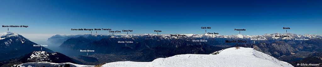
Monte Cadria 2254 m - Monte Colombine 2215 m - Monte Tofino 2151 m - Dosso Alto 2064 m - Monte Muffetto 2060 m - Monte Campellet (Nozzolo Grande) 2029 m - Monte Caplone (Cima delle Guardie) 1976 m - Cima Tombea 1950 m - Monte Tremalzo 1975 m - Monte Guglielmo 1957 m - Corno della Marogna 1953 m
Getting There
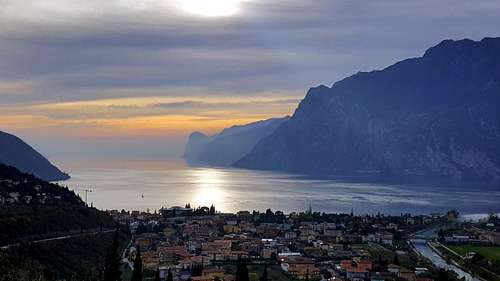
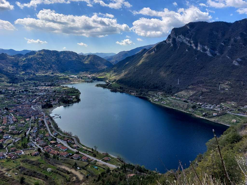
The main towns to approach this area are Bergamo to the West, Brescia and Verona to the South and Trento to the East. The main valleys which penetrate into the mountainous area here described are: the Val Camonica to the West, along the Eastern shore of Lago di Iseo, the SS345 delle Tre Valli, the Val Trompia and the Valle di Caffaro, the Val Sabbia, the Valli Giudicarie, skirting Lago d'Idro, the Valvestino. The West Gardesana road is the Easternmost access, running along the Western shore of Lago di Garda. Among the lakes located in the region, there are some of the largest Italian lakes: Garda, Iseo and Idro.
Le principali città vicine a questa zona montuosa sono Bergamo a ovest, Brescia e Verona a sud, Trento a est. Le principali valli di penetrazione sono: la Val Camonica ad Ovest, lungo la sponda orientale del Lago di Iseo, la SS345 delle Tre Valli, la Val Trompia e la Valle di Caffaro, la Val Sabbia, le Valli Giudicarie, la Valvestino. La strada Gardesana occidentale è l'accesso situato più a oriente, situato lungo la sponda occidentale del Lago di Garda.
Catena delle Tre Valli
The Catena delle Tre Valli (Three Valleys Chain) stretches from the southern foothills of the Adamello massif to the Po Valley, running between the Val Camonica, Val Trompia and Valle Sabbia. It's the Westernmost area, including the Subgroup of Punta Almana and Punta Tisdel, the Massif of Monte Guglielmo, the Setteventi-Muffetto-Colombine chain, the Piccole Dolomiti Bresciane and the Ario-Savallo-Sonclino subgroups.
La Catena delle Tre Valli si estende dalle propaggini meridionali del massiccio dell'Adamello fino alla Pianura Padana, tra la Val Camonica, la Val Trompia e la Val Sabbia.
È la zona più occidentale e comprende il sottogruppo di Punta Almana e Punta Tisdel, il massiccio del Monte Guglielmo, la catena Setteventi-Muffetto-Colombine, le Piccole Dolomiti Bresciane e i sottogruppi Ario-Savallo-Sonclino.

Main Summits
Monte Colombine 2215 m - Dosso Alto 2065 m - Monte Muffetto 2060 m - Corna Blacca 2005 m - Monte Guglielmo 1957 m - Cima Caldoline 1842 m

|

|
Monti del Garda
Despite never reaching 2000 meters of altitude, the mountains located in this area are wild and low-anthropized, with steep limestone cliffs. The climate is strongly mitigated by the basin of Garda Lake, with vegetation and character almost Mediterranean. This area is lying to the East of Valle Sabbia, between the lakes Garda and Idro and includes these Subgroups: Stino-Cingla, Caplone, Avez, Monte Carone, Denerio, Pizzocolo, Manos-Zingla, Tremalzo and Monte Corno.
Nonostante non raggiungano i 2000 metri di altitudine, i Monti del Garda sono selvaggi e poco antropizzati, con scoscese pareti calcaree. Il clima è fortemente mitigato dal bacino del lago di Garda, e la vegetazione presenta carattere quasi mediterraneo. Questa area si trova ad est della Valle Sabbia, tra i laghi Garda e Idro e comprende i seguenti sottogruppi: Stino-Cingla, Caplone, Avez, Monte Carone, Denerio, Pizzocolo, Manos-Zingla, Tremalzo e Monte Corno.
Main Summits

|

|
Main Summits
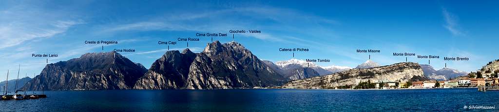
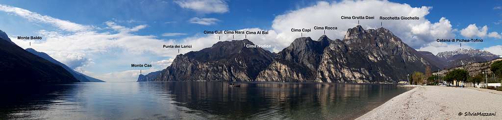
Monte Caplone (Cima delle Guardie) 1976 m - Monte Tremalzo 1972 m - Corno della Marogna 1953 m - Cima Tombea 1950 m - Cima Avez 1895 m- Monte Corno 1731 m - Monte Carone 1621 m - Monte Pizzocolo 1581 m - Monte Traversole 1442 m - Monte Guil 1322 m - Cima Comèr 1279 m - Cima Al Bal 1260 m - Cima S.A.T. 1246 m - Cima Rocca 1089 m

|

|

|

|

|
Monte Bestone 917 m - Cima Capi 909 m - Punta dei Larici 908 m - Monte Castello di Gaino 870 m - Cima Nodice 860 m

|

|
Alpi di Ledro
The Alpi di Ledro are without any doubt the wildest group of the Prealpi Bresciane, including the highest peak of the whole area, Monte Cadria. Their origin is glacial and the peaks located in this area are limestone-made, sometimes imposing and majestic. This fact together with the climate justifies the name "Alps" attributed, although in reality we are talking about a pre-alpine group. This area is lying to the West of Northern Lago di Garda and includes the chains of Cadria and Pichea, and the subgroups Stigolo, Altissimo and Rocchetta.
Le Alpi di Ledro sono senza dubbio il gruppo più selvaggio delle Prealpi Bresciane e includono la vetta più alta dell'intera area, il Monte Cadria. La loro origine è glaciale e le vette situate in quest'area sono principalmente calcaree, a volte imponenti e maestose. Questa caratteristica, unitamente ai fattori climatici, giustifica il nome "Alpi", anche se in realtà stiamo parlando di un gruppo prealpino. Questa area montuosa si trova ad ovest della parte più settentrionale del Lago di Garda e include le catene di Cadria e di Pichea e i sottogruppi Stigolo, Altissimo e Rocchetta.

|

|
Main Summits
Monte Cadria 2254 m - Monte Tofino 2151 m - Dosso della Torta 2156 m - Corno di Pichea 2147 m - Monte Altissimo 2128 m - Corno di Lumar 2063 m - Monte Gavardina 2047 m - Monte Campellet (Nozzolo Grande) 2029 m - Cima Parì 1988 m

|

|

|
Nozzolo Piccolo 1927 m - Cima Sera 1909 m - Cima Sclapa 1887 m - Mazza di Pichea 1879 m - Cima d'Oro 1802 m - Monte Stigolo 1699 m - Monte Vies 1699 m - Rocca Pagana 1668 m - Cima Valdès 1578 m - Rocchetta Giochello 1540 m
Nature and climate

|
")
|
Notwithstanding being very populated, the Prealpi Bresciane and Gardesane include some parks and protected areas, as Parco Regionale dell'Alto Garda Bresciano and Parco del Barberino, as well as Biotopo Lago d'Idro, Lago d'Ampola and Fiavè. In the Prealpi Bresciane there are no glaciers. From the point of view of the climate it should be emphasized that in general the climate is not particularly severe, because of the altitude of the Prealpi Bresciane, not particularly high ( the highest point is the summit of Monte Cadria 2254m). In any case it is not possible to generalize the information about the climate in this pre-Alpine area. In fact the Prealpi Bresciane have an inhomogeneous geographic location and consequently show very different settings, both in terms of climate and vegetation. Some mountain groups, especially those facing the extensive surfaces of water of Lago Iseo and Garda have even a mild climate. Especially some subgroups overlooking the Garda lake have almost a sub-Mediterranean character with oases xero-thermal, while other groups, such as the Alpi di Ledro, have alpine characteristics. As a result of all these factors, the biodiversity is particularly strong. From the botanical point of view here is detected a high number of endemic species as Saxifraga tombeanensis, Physophlexis comosa, Primula spectabilis.

|

|

|
Nonostante siano molto popolate, le Prealpi Bresciane e Gardesane comprendono alcuni parchi e aree protette, come il Parco Regionale dell'Alto Garda Bresciano e il Parco del Barberino, così come i Biotopi del Lago d'Idro, del Lago d'Ampola e Fiavè. Nelle Prealpi Bresciane non ci sono ghiacciai. Dal punto di vista climatico va sottolineato che in generale il clima non è particolarmente severo, a causa dell'altitudine non molto elevata (il punto più alto è la cima del Monte Cadria 2254 m). In ogni caso non è possibile generalizzare le informazioni sul clima in questa area prealpina in quanto le Prealpi Bresciane e Gardesane hanno una posizione geografica disomogenea e di conseguenza presentano aspetti molto differenti, sia in termini climatici che vegetazionali. Alcuni gruppi montuosi, in particolare quelli che si affacciano sulle vaste superfici d'acqua del Lago d'Iseo e del Lago di Garda, hanno addirittura un clima mite. Soprattutto alcuni sottogruppi che si affacciano sul lago di Garda hanno un carattere quasi sub-mediterraneo con oasi xero-termali, mentre altri gruppi, come le Alpi di Ledro, hanno caratteristiche spiccatamente alpine. Come risultato di tutti questi fattori, la biodiversità è particolarmente forte. Dal punto di vista botanico si rileva un numero elevato di specie endemiche come Saxifraga tombeanensis, Physophlexis comosa, Primula spectabilis.

|

|
Red Tape
There are not special restrictions in climbing, hiking and mountaineering.
Non ci sono particolari restrizioni per l'arrampicata, l'escursionismo e l'alpinismo.
Accomodation
This area is a primary touristic destination, offering several hotels, agriturismo, bed and breakfast, renting rooms and apartments.
Questa zona è una meta turistica primaria, che offre diversi hotel, agriturismi, bed and breakfast, camere in affitto e appartamenti.
Meteo
Regarding the Eastern subgroups, located in the Trentino county or close to its border, it's useful the following forecast website:
Per quanto riguarda i sottogruppi orientali, situati nella regione Trentino o vicino al suo confine, è utile il seguente sito di previsioni:
Guidebooks and maps
"Prealpi Bresciane" by Fausto Camerini - Collana Guide dei Monti d'Italia, CAI-TCI