
-
 5602 Hits
-
 72.77% Score
-
 5 Votes
|
|
Mountain/Rock |
|---|---|
|
|
42.72310°N / 109.20125°W |
|
|
Sublette |
|
|
Scrambling |
|
|
Summer |
|
|
11640 ft / 3548 m |
|
|
Schiestler Peak
At the southern end of Big Sandy Lake, a popular staging location for expeditions into the Southern Winds, lies Schiestler Peak. It's essentially an extension of nearby Temple Peak, and provides outstanding views South and East. Due to its proximity to numerous camping locations, Schiestler is solid introduction for beginner and intermediate mountaineers.
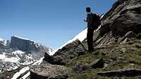 Nearing the grassy plateau, East Chute, above the boulder field
Getting There
Access the Southern Winds is had via the Big Sandy Trailhead, a relatively remote access point south of Pinedale. Despite this, and the nearly 20 miles of dirt road required to reach it, Big Sandy remains a popular trailhead. There are 3 Main Routes : Southwest Slopes (1,2) You can reach this flank of Schiestler by crossing the Big Sandy River at Big Sandy Lake's outlet. You can also follow the mining road from the Temple Creek summer homes in Big Sandy Opening.
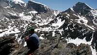
 Boulder Field, East Chute, Schiestler Peak
East Chute (1,3) Between the true summit and north summit is a long boulder slope. The only problem is skirting the immense blocks. This route can be reached by skirting around Big Sandy Lake to the east, crossing several streams and pushing for a large expanse of granite bumps as seen from Big Sandy Lake campsites. The boulder fields are reached by diverted to climber's left prior to reaching a large snowslope. Above the boulder field is a single, short Class III and IV pitch followed by a long push up sometimes grassy alpine plateau. East Face, Left Edge (II, 5.7) The east face's most easily recognized feature is a dihedral and chimney in the shape of a backward "S". To its left, near the face's edge, is the left facing dihedral this route follows.
 Summit of Schiestler Peak, Wind River Range
chugach mtn boy - Jul 14, 2014 8:57 pm - Voted 1/10
Copyright issueIt's nice having this peak on Summitpost, but this writeup is too derivative. Some of it is word-for-word from Kelsey's book. Not cool.