
-
 7560 Hits
-
 79.04% Score
-
 10 Votes
|
|
Mountain/Rock |
|---|---|
|
|
37.42800°N / 108.0869°W |
|
|
La Plata&Montezuma |
|
|
Hiking, Mountaineering, Scrambling |
|
|
Spring, Summer, Fall |
|
|
13123 ft / 4000 m |
|
|
Overview
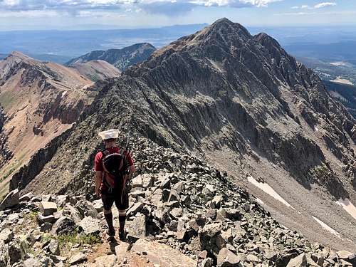 Spiller Peak - striating the approach to the Knife Ridge
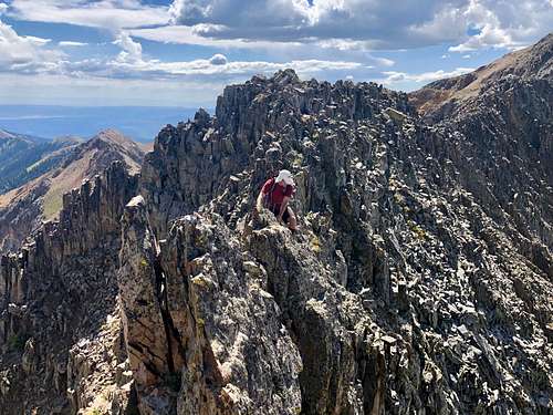 The Knife
La Plate Range is a small section of San Juan Mountain located northwest of historic town of Durango. You will not encounter many hikers/climbers here thanks to its far location from Denver. The whole range has only 3 ranked 13ers: Hesperus (one of the sacred mountains for Navajo people), Lavender Peak and Babcock Peak.
Why unranked? Colorado has a rule of at least 300 feet prominence with its neighboring peak. The saddle between Babcock and Spiller is at 12,940 feet and this gives us only 183 feet of elevation gain, but don't expect an easy traverse between these two peaks. The connecting ridge is called The Knife and is one of the fine Colorado Mountain traverses offering plenty of exposure and scramble at mostly class 3 difficulty. Make sure that weather co-operates prior attempting the traverse, there is no escape from it. Also, keep in mind that traverse starts on a lower summit of West Babcock Peak. The main summit is Middle Babcock - see SP page for description for Babcock Peak and study this route since it could be confusing with its many couloirs to choose from. One person called it in his trip report : Gully Slot Machine"; a name I think is very adequate.
Quad: La Plata
Parent Lineage: Babcock Peak
Nearby Peaks:
- Babcock Peak 0.57 miles
- Mt. Moss 0.90 miles
- Lavender Peak 0.98 miles
- Hesperus Mountain 1.17 miles
- Centennial Peak 1.43 miles
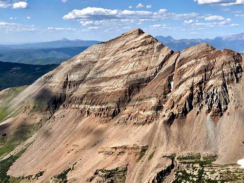 Hesperus Mountain as seen from Spiller Peak (one of the Navajos secret mountains).
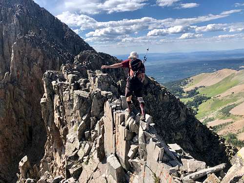 The Knife
Colorado Scrambles Climbs Beyond the Beaten Path with Dave Cooper provides a nice description of The Knife. We mostly followed his recommendations. Dave Cooper wrote in his book that Babcock to Spiller Peak via the Knife is one of the finest traverses in the state. The Knife looks fearsome from any vantage point, but in reality this ridge is quite moderate, although you can expect significant exposure in places. The ridge is the place to be in a thunderstorm, since there are essentially no bailout spots once you commit to it.
Getting There
Babcock Peak is pretty close to a beautiful and historic town of Durango. Take US 160 west from Durango to the small town of Hesperus. Turn north on La Plata Road for 8.5 miles to its junction with Boren Creek Road. La Plata Road is nice, passable by 2 WD vehicles. Boren Creek Road is steep, rough 4 WD road. I chose to drive only about 1/4 mile and parked on a large pull out on the north side of the road. Boren Creek Road is easier to hike than drive. It is narrow and very rough. It ends up high up in the basin below The Knife - ridge connecting Babcock Peak with Spiller Peak.
Route
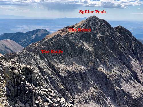 The Knife, The Notch, and Spiller Peak as seen from West Babcock
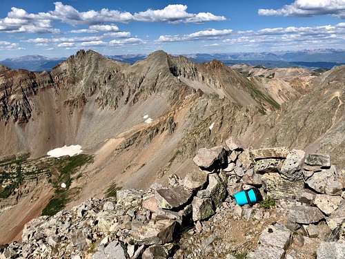 Spiller Peak summit with Mt. Moss and Lavender Peak in the distance.
 There was still a lot of hard snow inside the couloir, and unfortunately we had no crampons, so we ended up scrambling between the rock and snow. We ascended Middle Babcock first since it is the main summit and then returned back to this couloir and continued up towards West Babcock. The couloir was filled still with snow (unusual for late August), so we scrambled in between the rock and snow banks (we left our crampons in the car). Please note there is not direct descent from Middle Babcock to the saddle with West Babcock unless you bring a rope and will rappel down. There are slings around a boulder there for rappelling.
The route up West Babcock is easier than Middle Babcock a very few class 3 moves, mostly class 2. It is nice to take a break on its summit and check out The Knife. The route is straightforwards, try to stay on the ridge as much as possible. The descent from West Babcock is easy and wide - class 2. Then the ridge narrows and is like a knife at a few sections. I expected kind of more confluent rock, but the ridge is rather of stack of pretty solids small sharp rocks and pinnacles. The ridge gets technically more interesting towards the Spiller Peak. Enjoy the views and exposure! After reaching the major notch in the ridge, descend it on the right side. Down climb a loose couloir for about 50 meters until you gain grassy and rocky ledges in a shallow gully on the west side of the notch. This gully brings you to the summit of Spiller Peak - class 2+/3 scramble, and avoids the second notch on the Knife.
The summit of Spiller Peak has a nice cairn, summit register with open top and great views. Hesperus Mountain looks truly amazing (sacred mountain for Navajo).
Descend: start initially on an easy terrain towards Burwell Peak, south. When we reached some obstacle on the ridge, we dropped into a loose gully, covered with moving gravel and descended down. This section was rather unpleasant and our shoes got filled with rocks. We angled back towards the mine and road where we started out ascent.
Red Tape
Hiking, driving the 4WD Boren Road are free.
When to Climb
Summer and early fall are obviously the easiest time with fast approach on dry land. Winter and spring pose high avalanche risk.
Camping
There are several developed campsites along La Plata Road.
Snowslide Campground: is 6 miles up the canyon from US 160. For information click here.
There is also primitive camping along the road. The land is part of national forest.
External Links
- Spiller Peak on List of John
- Spiller Peak on 13ers.com
- Spiller Peak on Peakbagger.com
- Earthline: The American Blog