
|
|
Mountain/Rock |
|---|---|
|
|
44.74917°N / 70.54253°W |
|
|
3068 ft / 935 m |
|
|
Overview
Tumbledown Mountain is located in western Maine near Weld Village. While not the highest mountain in the region, it is easily the most interesting. The south face of Tumbledown is comprised of impressive 700+ foot cliffs which form the northern side of Byron Notch. While Tumbledown's three open summits are impressive (West, East, and North Peaks), the most outstanding aspect of the mountain is Tumbledown Pond. The Pond is situated at approximately 2,800 feet and is surrounded on three sides by higher elevations. Of Tumbledown's three peaks, North Peak is the highest at 3,090 feet. East Peak and West Peak are only slightly lower.Tumbledown is not a secret and will be fairly crowded on nice weekends, particularly the area immediately around the pond. Solitude seekers should plan to relax on either West Peak or the high point of Parker Ridge.
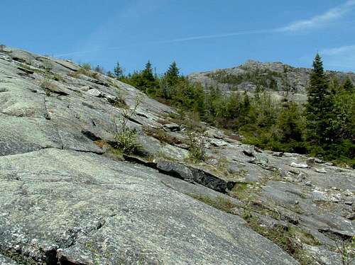
North Peak rises above the slabs of East Peak.
BASIC ROUTE INFORMATION
Brook Trail
The Brook Trail is the easiest and most direct route to the Pond. It is also the most popular. The trail approaches from the south and starts out on an old woods road, passing primarily through birches and other hardwoods. At 1 mile, the trail turns right and begins to climb more steeply following a brook to the pond outlet through pines and spruce. Distance from the road to the pond is 1.5 miles with approximately 1,600 feet of elevation gain.
Parker's Ridge Trail
According to the Maine Mountain Guide (8th ed., AMC), this is the oldest trail up Tumbledown. The trail approaches from the southeast and initially rises moderately but steepens as it passes over three ledges. The trail eventually comes out into the open and traverses Parker's Ridge. The ridge walk affords excellent views across Byron Notch, as well as to Tumbledown Pond, the surrounding Tumbledown massif, and to neighboring Little Jackson Mountain. Distance from the trailhead to the pond outlet is 2.2 miles with approximtely 1,700 feet of elevation gain.
Loop Trail
The loop trail is the most difficult trail up Tumbledown. It is very steep in places and the upper portion of the trail is a bit hard to follow in places. Do not underestimate this trail. This ruggedness, however, does make for a fun ascent. The trail approaches from the south and rises steadily to the open Great Ledges where there are excellent views of the 700 foot Tumbledown cliffs. From the ledges, a gully is clearly visible and the Loop Trail begins to climb to the ridge in this gully. The upper part of the gully is very steep and near the top appears to end at a point where huge boulders block further travel. The trail actually passes up through the boulders (enter a gap to the left). Hikers are assisted by metal rungs affixed to the rock. Large packs may have to be removed as there is minimal space within the crack. This section of trail is probably impassable for dogs and maybe for small children. The trail emerges from the crack just shy of the ridge and ends at the Tumbledown Ridge Trail. Distance to the ridge is 1.9 miles.
Tumbledown Ridge Trail
The Tumbledown Ridge Trail starts at the pond outlet and traverses East Peak, descends to a saddle where it meets the Loop Trail, and continues to the summit of West Peak. This trail can be used with the Loop Trail and the Brook Trail to make a nice loop hike. I recommend going up the Loop Trail and coming down the Brook Trail. A pleasant 1.4 mile logging road walk is required to get from the Brook Trailhead to the Loop Trailhead.
 |  |  |  |
Getting There
From Portland, Maine, take I-95 north to Route 4 in Auburn. Follow route 4 through Auburn, Turner, Livermore Falls, and Jay. Turn left on 156 and follow into Weld Village. At the four way stop in Weld, go straight. Turn left at Webb Corner (large sign). Within about 1/2 mile, a logging road (Byron Road) leaves straight ahead in a 90 degree turn. Approximately 2.7 miles from Webb Corner, a logging road (Morgan Road) leaves Byron Road on the right. This road ends at a small parking area for the Little Jackson Trail. The Parker Ridge Trail diverges left from the Little Jackson Trail less than 0.5 miles from the parking area.The Brook Trail leaves Byron Road approximately 4.4 miles from Webb Corner. The Loop Trail also begins on Byron Road approximately 5.8 miles from Webb Corner. Both the Loop and Brook Trailheads are fairly well marked but I suggest setting your trip odometer when you make the turn at Webb Corner so you know you are in the general area. The DeLorrme Maine Atlas and Gazetteer is an essential tool for the Maine hiker.
Red Tape
Byron Notch Road is closed in the winter. Very recently, large portions of land surrounding Tumbledown, including the summit ridge and trailheads for the Loop Trail and the Brook Trail, have come under the management of the Maine Bureau of Public Lands. There was some controversy, however, on access to the Parker Ridge Trail. For up to date info on future conservation projects, as well as access restrictions, visit the Tumbledown Conservation Alliance website. As of 5/28/06, the road leading to the Parker Ridge Trailhead was not gated.Camping
There are no designated campsites on the mountain but it is not uncommon to see a tent or two pitched near the pond. Some of the aforementioned controversy regarding the Parker Ridge Trailhead dealt with the removal of a lean-to. Check the above link for additional info. A portion of Mount Blue State Park is located on the shore of Webb Lake and camping is available.  |  |
When to Climb
Tumbledown can be climbed year round but a 4 to 5 mile road walk is required in the winter. The mountain will be crowded most nice summer weekends. Late fall is probably the best time to visit but snow and ice are common by October. Expect to encounter black flies in the spring.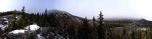
Tumbledown Panoramic
Mountain Conditions
Tumbledown rises about 2,000 feet above the surrounding valleys so conditions may vary(3 to 5 degrees cooler per 1,000 feet) and windy conditions are common. Also, the trail along the ridge is not that well marked. Use caution if visibility is low or in wet conditions as the ridge has a few ledges, particularly around the top of the Loop Trail gully.
imzadi - Sep 20, 2008 10:49 pm - Voted 9/10
Updated trail mapWe were there today (9-20-08) and they have updated the trail system. There are parking areas located about a tenth of a mile AFTER the trail head. Both parking areas (Loop trail and Brook trail) are well marked with signs that are located right on the side of the road at the entrance. The trail head, while very well marked, can be difficult to find (especially once you've spied the sign for the parking lot and are foculsed on this. The actual sign for the trail head is about 30 feet off the road in the woods. If you aren't looking...you MAY miss it. They have also added a connector trail that leads from the Brook trail to the Parker Ridge and the Jackson trails. The distance is not quite on. From the Brook trail to the Loop trail (making a popular looP) is about 1.3 miles...not 1.4. If you use the odometer...1.4 miles leads you to a slight road-like thing that, after going in about .1 miles DOES have blue blazes!! But these disappear not long after this. There are also blue blazes (very old and faded) that lead off from inside the parking lot. So...if it doesn't clearly STATE it's the trail...it isn't. Once you are on the trails...they are VERY WELL marked. I've attached to this object a picture of the trail map that is at the trail head of the brook trail
imzadi - Sep 21, 2008 10:15 am - Voted 9/10
Change in the name?Another thing that was a bit confusion was finding the turn off from the main route onto the road. In the Falcon Guide, the AMC Maine Mountain Guide, and the DeLorme map...the name of this courned is WELD corner. However, when you get there...there is a big sign labeling it WEBB corner.
Slibs - Aug 20, 2010 10:43 am - Hasn't voted
New TrailsThere is now a trail going to North Peak it starts on the Tumbledown Ridge Trail about half way up West Peak. Red Blazes and cairns mark the trail.
injektilo - Aug 26, 2010 1:05 pm - Hasn't voted
Re: New TrailsCool! I need to get up there and check it out so I can update the page. Thanks again.
blbrandt - Sep 6, 2010 12:25 pm - Hasn't voted
Directions to Parker's Ridge trail headThe "logging road" at the west end of Webb Lake is now marked with a sign. It is West End Road. Going straight on this road puts one on to Byron Rd., also signed, very quickly. Morgan Rd., the logging road to the Jackson and Parker's Ridge trailhead, is just past a cemetery that is on the right side of Byron Rd..
HikingTurtle - May 3, 2014 12:17 pm - Hasn't voted
Names and PlacesTumbledown Mountain is one of the many gems in Maine. However, Names and Places might be different, I would ask a local person. Remember publications vary with information. Use summitpost.org for information. Please feel free to eMail me: HikingTurtle