
-
 3230 Hits
-
 83.69% Score
-
 17 Votes
|
|
Route |
|---|---|
|
|
45.32879°N / 7.14447°E |
|
|
Mountaineering, Ice Climbing |
|
|
Spring, Summer |
|
|
A long day |
|
|
Alpine D |
|
|
Overview
Uja of Ciamarella North Face Direct
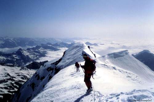
Uja of Ciamarella - or simply Ciamarella - 3676 m - is a great mountain belonging to the Southern Graie Alps and is the highest elevation of the Valli di Lanzo. It's a superb peak located entirely in Italian territory, in fact the border ridge between Italy and France runs to the West of the summit. The imposing Ciamarella North face is a 450 meters high wall, mainly ice-covered. Once the wall was covered with great seracs and the classic North face had three different routes, while nowadays the ice cover of the wall has been resized because of the general retreat of glaciers. Therefore the only safe ice climbing on NE ice face remains is the Right Direct route, running on the right of the wall. On the summit it’s located a bronze bust of San Leonardo Murialdo , who climbed Uja di Ciamarella in the year 1867.

|

|
Getting There
Ciamarella North wall can be approached both from Italy and from France.
Access from the Italian side
The starting point is the settlement of Forno Alpi Graie (TO). From Turin reach the Valli di Lanzo and Forno Alpi Graie m. 1219, where the road ends.
Walking approach to Bivacco Soardi-Fassero m. 2297
Ciamarella approach from the italian side is longer but amazing, along the wild Vallone di Sea, dominated by impressive vertical walls. The starting point is the village of Forno Alpi Graie m. 1219; From Forno Alpi Graie take the dirt road with indications for the sanctuary. Take the road that climbs steeply to the right. After passing some buildings of the aqueduct, reach the point where the road crosses the Stura di Sea stream. Here leave the road and continue on the path that stays on the right side of the valley (orographic left). The path continues under the Costiera Malatret along the valley floor and after a short climb crosses the stream near the Gias Balma Massiet m. 1500. The trail continues now on the right bank of the river, reaching the plane of Sea, from where after crossing the stream reaches the enormous boulder of Alpe di Sea m. 1785. The trail reaches later the vast and wide plateau of Gias Nuovo m 1888. Cross the plateau and after a narrow gorge, a bridge and a stretch of rocky stairs the path comes out on the plateau of Gias Platou m. 2189. Continue climbing on steep grassy shores ahead of Bivouac Soardi-Fassero. Up again a grassy ridge and finally with some serpentines in steep terrain, you will reach the bivouac m. 2297 - 3.30 hours from Forno Alpi Graie.

|

|
Access from the French side
The starting point is Bonneval-sur-Arc. From Modane follow the D1006 towards Col du Mont Cenis, in Lanslebourg leave this road to take the D902 towards Col de l'Iseran. A Bonneval-sur-Arc, follow a narrow road which joins the hamlet of Ecot m. 2020. Park the car in one of the 2 parking available.
Walking approach to Refuge des Evettes
A comfortable and well marked path starting from the Ecot parking gets to the shelter - 1, 45 hour from Ecot
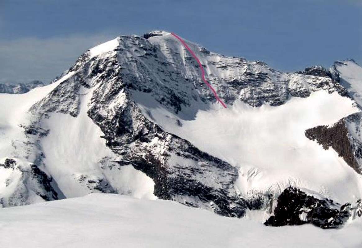
North Wall Right Direct route report
Uja di Ciamarella North Face - Right Direct Route
Difficulty: Alpine D-, 55° max
Length: 450 m.
Exposure: mainly North
First ascent: G. Dodero, E. Guidetti and M. Piolti 1-7-1935
Superb stunning icy face with a regular 45° slope and long sections of 50°-55°, requiring a very good technical background, not exposed to seracs' falls.
Approach from Bivacco Soardi-Fassero m. 2297
From the bivouac Soardi–Fassero (joined the day before) head to West and descent almost to the bottom of the Sea valloon. Follow it across snowfields and scree up to the Sea Glacier in huge retreat, with an obvious great serac. Head to South, circumvent the serac passing at the base of the East buttress of Punta Tonini, reaching the upper plateau of Tonini glacier and from there head directly to the bergschrund at the bottom of North Wall (difference in level from the bivouac: 900 m).

|

|
- Approach from Refuge des Evettes m. 2588
From the Refuge des Evettes (joined the day before) descend on the Evettes plateau and cross it towards South heading to the Evettes Glacier. Follow the right bank of the glacier to gain the upper plateau. From here head to South-East in the direction of Colle Tonini to the left of Little Ciamarella. Up the slope that gradually straightens up to 45°. Cross the Col and traverse to the East to reach the foot of the North face of Ciamarella. Route report - This route is located to the right of a characteristic rocky outcrop in the upper part of the North wall. After crossed the bergschrund, climb the ice-slope following a linear line. In the upper section the slope steepens, reaching the 55°, and the route joins the Central route or Route Ferreri coming from the left, reaching the summit.
Descent: The descent along the easy Normal Route leads to Pian della of Mussa, situated in another valley, therefore to return to Forno Alpi Graie, the starting point, the way is descending along the East Ridge. From the summit return to the junction of the ridges and take the airy and sharp East ridge, that comes down to the quote 3637 or Pan di Zucchero (Sugarloaf). Follow the ridge to the right, then a rocky stretch and the center channel, reaching the level plateau Albaron di Sea glacier. With a wide semicircle from right to left reach the plateau of Sea glacier from which up to the bivouac Soardi-Fassero.
Essential Gear
Take the conventional equipment for a climb of this kind (listed Alpine D): 50 m. rope, 2 ice axes, crampons, harness, helmet, carabiners, 2 or 3 slings, ice screws
Red Tape
There are no fees or permits needed to climb.
Huts and Bivouacs
- Bivacco Soardi-Fassero 2297 m
Owner: C.A.I. UGET Torino/Ciriè
Situation: Upper Vallone di Sea
Open: always open
Size: 14 persons
Getting There: from Forno Alpi Graie along the Vallone di Sea - 3,45 hours

|

|

Owner: C.A.F. Lyon-Villerubanne
Situation: Glacier de l'Evettes
Open: end of March - 15 of May and 15 of June - 15 of October
Size: 64 persons + 20 in the winter shelter
Getting There: from Ecot - 1,45 hours on path
When to climb
From May to July. The climb is to be performed early in the season, especially because of ice, appearing rapidly in the face.
Meteo
Meteo Regione Piemonte
Meteo France
Guidebooks and maps
Guidebooks
“Gran Paradiso e Valli di Lanzo” by Gian Carlo Grassi - Zanichelli Ed.
“Alpi Graie Meridionali” by G. Berutto and L. Fornelli –Collana Guide dei Monti d’Italia CAI-TCI
 |
 |
 |
Maps
ICG Valli di Lanzo e Moncenisio 1:50000
IGN TOP25 3633 ET Tignes - Val d’Isère - Haute Maurienne