


-
 1311 Hits
-
 76.66% Score
-
 7 Votes
|
|
Route |
|---|---|
|
|
45.89030°N / 7.24835°E |
|
|
Mountaineering, Ice Climbing |
|
|
A long day |
|
|
Class 3 |
|
|
III |
|
|
Note
|
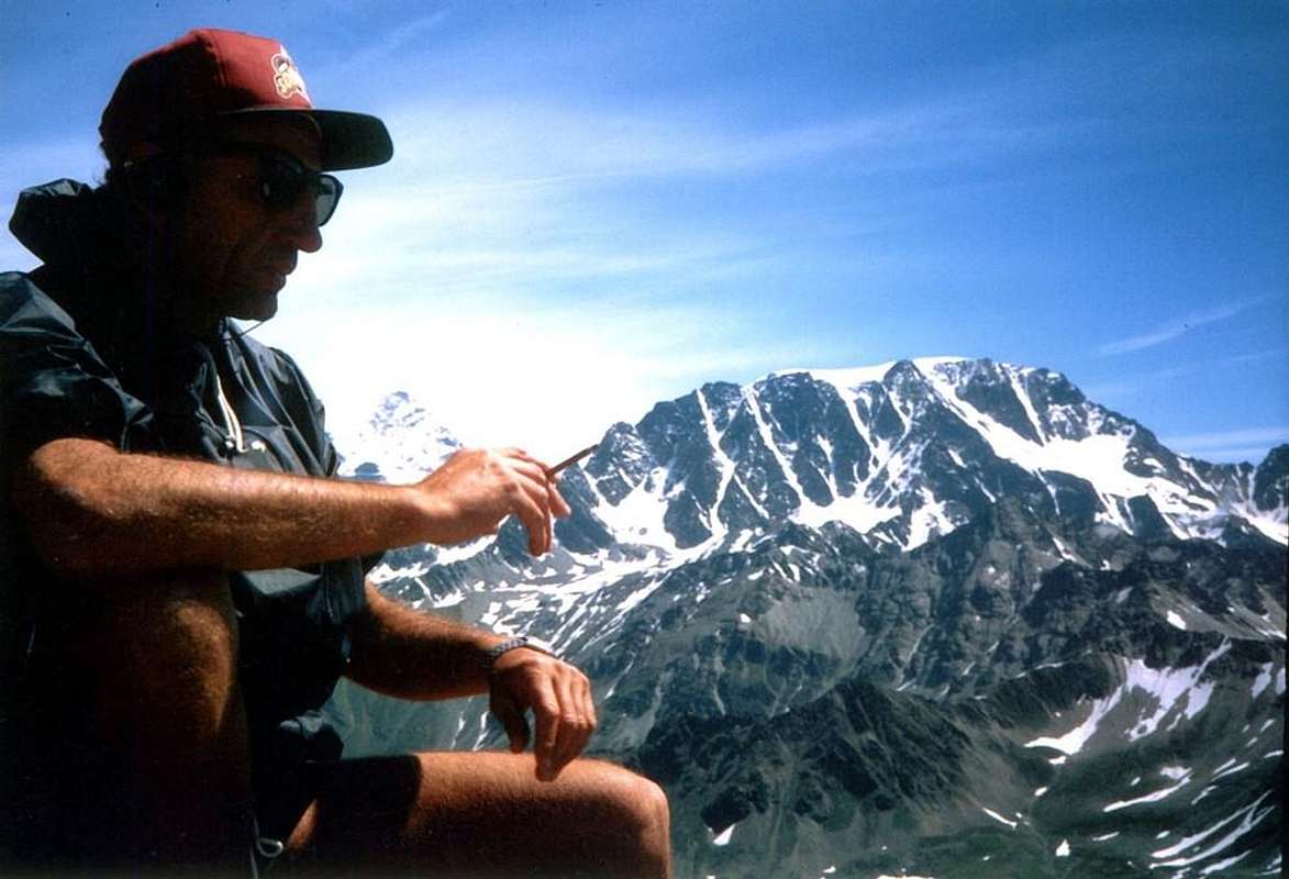
La montagna chiama i suoi figli, ed essi rispondono fedelmente al suo appello… Osvaldo Cardellina, Diario alpinistico, 1964-65 Page texts: @ OsvaldoCardellina "Osva", passed away on May 2, 2022. Page owners: Christian Cardellina e Osvaldo Cardellina. Any updates from September 12, 2022: Antonio Giani, page administrator, friend and climbing companion. Testi della pagina: @ OsvaldoCardellina "Osva", scomparso il 2 maggio 2022. Proprietari pagina: Christian Cardellina e Osvaldo Cardellina. Eventuali aggiornamenti dal 12 settembre 2022: Antonio Giani, amministratore della pagina, amico e compagno di salite. |
Menouve Overview Molline
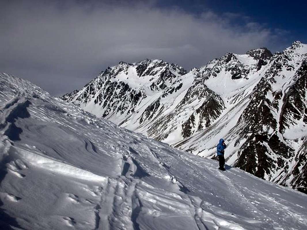
A brief summary of all the routes known at Mont Velan or Vélan and, for the local inhabitants, Mont V'lan. The personal criterion, specifically wanted and chosen, consists in has been maintained to proceed in an anti-clockwise direction starting from the West Ridge (the side with the sector more Western of the entire mountain), overlooking the Colle di Annibale or Hannibal's Pass , which constitutes the route of the first climbers on August 31th, 1799, by the Monk-Naturalist Laurent-Joseph Murith with the local hunter Genoud; even if the first section was traveled on the Proz 's Glacier side to then join it to two thirds of the route at the overlying and overhanging minuscule Aiguille du Déjeuner (3.346m). Then, to follow, the itineraries of the Southwest Versante (Slope, broken into two sectors: with the Mont Velan Glacier at the superior part and a half-dozen grassy-rocky bouncing down and big ribs below, interspersed with steep detrital gullies), above the double Vallone (great valley) of Menouve and Molline also Moline in turn above the Municipality of Etroubles (1.280m, 14,8 km from Aosta Town). The same reaches the Sella di Faceballa (often snowy or with debris and some boulders a wide saddle in altitude of 2.880m), from which it gives birth to the long Contrafforte (Buttress) South-soutwest that end, safter having formed numerous peaks including La Salliaousa (3.322m) at Mont Saron (2.631 m), just above the Municipality of Allein. Beyond this long buttress, marked with direction from North to South, the adjacent Conca di By opens to the East and which, widening like a fan, "breaks" itself against the ridge that from Mont Gelé (3.518m) for after descends towards the Southwest passing the various Mont Morion (Northern 3.484, Central 3.487, Southern 3.497 meters) to end with Monte Berrio (3.075m), above the Municipalities of Ollomont / Valpelline. A synthetic discussion with detailed analysis that we have already made in "ALL ROUTES on Italian side to MONT VELAN or V'LAN (Conca di By / Comba Berruard") / 1 ", while now we are going to analyze what is inherent in the double valley above Etroubles Municipality, that is more West: this side is contained between the Colle di Annibale also Hannibal's Pass (2.992 m) and the Sella di Faceballa (3.280m), as well as the nearby and homonymous hill (3.239 meters, I.G.M.). A rather "hidden" side and in the past scarcely visited, if not towards the hills, probably by smugglers and hunters, the former, as well as exclusively the latter, the second. Even the routes traced on the South-West side, which then "rounds" in the South-Southwest, refer to the early beginnings of the last century; in fact, we must wait for the publication of the C.A.I./T.C.I. in "Guide of the Italian Mountains, Pennine Alps Vol. I" by Gino Buscaini (Milan 1971) to arouse, if not interest, at least curiosity towards this neglected and abandoned slope. The construction of the new Molline Refuge (2.400m), erected on the grassy promontory, of the valley from which it takes its name also contributed. But perhaps, and even more, the attendance of the same through ski-mountaineering on an itinerary that constitutes a variant in the final rocky stretch of the route of 4 September 1901 (Guido Cibrario, F. Viale with the two Swiss guides Daniel and Omer Balley) , which exceeds the entire Mont Velan Glacier (with the exit more to the left of the one traced here in the opening photo and moved more towards the Quota or altitude 3.678 meters; so I have been observing on some fairly recent occasions).
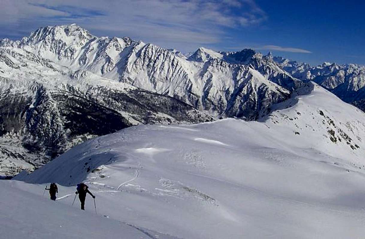 |
Un sintetico riassunto di tutte le vie conosciute al Mont Velan o Vélan e, per i locali, Mont V'lan. Si é volutamente mantenuto il criterio di procedere in senso anti orario partendo dalla Cresta Occidentale, sovrastante il Colle di Annibale (2.922 m), che costituisce la via dei primi salitori; anche se il primo tratto venne percorso sul lato del Ghiacciaio di Proz per poi congiungersi alla medesima a due terzi del percorso presso l'Aiguille du Déjeuner (3.346 m). Quindi, a seguire, gli itinerari del Versante Sudovest (spezzato in due settori: con nella parte superiore il Ghiacciaio del Mont Velan ed al di sotto una mezza dozzina di costoloni erboso-rocciosi, intercalati a ripidi canaloni detritici), al di sopra del doppio Vallone di Menouve nonché di Molline oppure Moline a sua volta soprastante il Comune di Etroubles. Il medesimo raggiunge la Sella di Faceballa (2.880 m), dalla quale "partorisce" il lungo Contrafforte Sud-sudovest terminante, dopo aver formato numerose cime tra le quali La Salliaousa (3.322 m), al Mont Saron (2.631 m), appena al di sopra del Comune di Allein. Oltre questo lungo contrafforte, contraddistinto con direzione da Settentrione a Meridione, si apre ad Oriente l'adiacente Conca di By che, allargandosi a ventaglio, si infrange contro la dorsale che dal Mont Gelé (3.518 m) scende verso Sudovest sorpassando i vari Mont Morion (N 3.484, C 3.487,S 3.497 metri) per concludersi con il Monte Berrio (3.075 m) al di sopra dei Comuni di Ollomont/Valpelline. Una disamina che abbiamo già effettuato in "ALL ROUTES on Italian side to MONT VELAN or V'LAN (Conca di By/Comba Berruard") /1", mentre ora andiamo ad analizzare ciò che é insito nel vallone sovrastante Etroubles, ossia più ad Occidente. Un versante, questo, contenuto tra il Colle di Annibale (2.992 m) e la Sella di Faceballa (3.280 m), nonché il viciniore ed omonimo colle (3.239 metri, I.G.M.). Un versante piuttosto "nascosto" e nei tempi passati scarsamente visitato, se non nei confronti dei colli probabilmente da contrabbandieri e cacciatori il primo, nonché esclusivamente da questi ultimi il secondo. Anche le vie tracciate sul Versante Sudovest, che poi si "arrotonda" in Sud-sudovest, si riferiscono ai primi inizi dello scorso secolo; bisogna infatti attendere la pubblicazione del CAI/TCI in "Guida dei Monti d'Italia Alpi Pennine Vol. I" ad opera di Gino Buscaini (Milano 1971) per suscitare, se non interesse, almeno curiosità nei confronti di questo negletto ed abbandonato versante. Indubbiamente ha contribuito anche la costruzione del nuovo Rifugio di Molline (2.400 m), eretto sul promontorio erboso, del vallone dal quale ne trae il nome. Ma forse, ed ancor più, la frequentazione del medesimo tramite lo sci-alpinismo su un itinerario costituente una variante nel tratto finale della via del 4 Settembre 1901 (Guido Cibrario, F. Viale con le due guide svizzere Daniel ed Omer Balley), che supera l'intero Ghiacciaio del Mont Velan (con uscita più a sinistra di quella tracciata qui nella foto di apertura e spostata maggiormente verso la Quota 3.678 metri; così mi é stato di osservare in alcune abbastanza recenti occasioni).
 |
Getting There
BY CAR:
- From TORINO, MILANO, etc: Motorway A5. Exit at IVREA or Quincinetto (PIEDMONT).
- From IVREA Town: before in West to Aosta, after in Northwest to Gignod, Etroubles, Saint-Oyen, Saint Rhémy en Bosses, (Southwestern and Northwestern Sides) and in North to Allein, Doues, Valpelline Municipalities.
- From Courmayeur Resort: before in East to Aosta, after in Northwest to Gignod and in North to Allain, Doues, Valpelline and Ollomont Municipalities.
- From Aosta Town to Allein and Doues Common in By Basin From Aosta City towards Variney Fraction and Gignod Commune (988m) with Great Saint Bernard SS.27 up to the alternative 1.074 meters, just before Condemine Hamlet (1.137m). Before crossing North the Artanavaz Torrent or Buthier de Bosses after in the Northwest towards Allein Municipality; from the fork 1.253 meters nearby this last, always with the Regional Road in Northeast, towards Doues Commune.
- From Allain/Doues to Ollomont/Valpelline Communes with By BasinFrom Allein Commune (1.251m), with Regional and Municipal Roads, to By Basin; from the entrance of this (various alpages reached by private dirt farms roads), through paths, up to the Mont Saron Southern Antesummit (2.681m) and traverse on crest to Tête de la Praz (2.751m) and Crou de Bleintse (2.824m).From Doues Commune (1.176m), with in asphalt Municipal Road, to By Basin; from this, with paths or dirt roads, to Mont Saron (2.681m), Crou de Bleintse (2.824m), Letey Refuge below Champillon Pass (2.430m), Mont Chenaille two Summits (3.144m), Tsa d'Ansermin (2.388m) and Monte Rotondo (2.572m). From Ollomont Commune (1.356m), trhough noumerous paths and various upper private dirt farms roads, towards the By Conca; from this numerous routes in all directions up to the Maria Cristina Rosazza at Savoie Bivouac (2.674m), nearby the Bégno Bà or Bas Hill.

All Routes description from Menouve/Molline Vallons
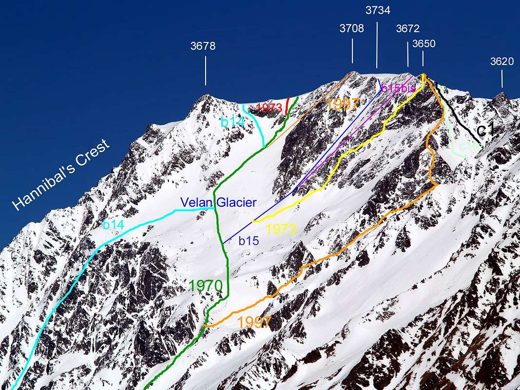
From Menouve/Molline Vallons: * West-northwest Face of Hannibal's Western Crest ad the same in final part to the Quota 3.678 meters: Laurent-Joseph Murith with Genoud, August 31th, 1779 (in first absolute ascent of Mont Velan). From F to PD- (rocky steps of I°/I°+): from Hannibal's Col (2.992m), sited on Italian/Swiss border between the Quota 3.678 meters of Mont Velan (3.734m) to the East and Testa Grisa (3.060m), in West-northwest, climb before on easy crest with broken rocks, then crossing in North (Swiss slope) some asperities reaching an evident rocky shoulder named Aiguille du Dèjeuner (3.346m); from this point to reach (in corrispondence with an Italian couloir from Molline Valley: see just below the subsequent route) the Southwestern Ridge from Faceballa Saddle (2.880m) and, just after the Quota 3.678 meters, the Summit Ice Cup (3.734m); 3h'00/3h'30 from Hannibal Pass; from Molline Bivouac (2.415m) 5h'00/5h'30; from the ban of transit into Menouve lower Valley at Quaye Alps (1.614m) 7h'00/8h'00. * VARIANT on Southwest Slope: ascent without transit on before suspended after hanging Velan Glacier (to the right in respect of this route) and even eluding to the right the Aiguille du Dèjeuner (3.346m). Unknown mountaineers with relative date; from nearby the Molline Alpage or homonym shelter (2.415 meters and not traced in the photocolor just above, but barely left by b14 itinerary) Velan Glacier. * Southwest Slope from Velan Glacier: Guido Cibrario, Franco Viale and swiss Mountain Guides Daniel Balley and Omer Balley, Sep. 04th, 1901; in asceny from nearby the superior Molline Alpage. From F to F+/PD- (rocky steps of I°/I°+/II°-/II°/II°+, even a brief passage of III°-) mixed route with height of 834 meters and lenght about 1.000/50 meters from the rocky base; 1.263 meters, sited between the first second rocky rib and lenght about 1.500 meters) starting from "Montagna" Moline (2.424m) below the Velan Glacier or from the only adjacent (open since summer 2005) Molline's Shelter (2.215m), both sited on Italian Molline's Valley. To continue North along the detrital valley floor up to the basal couloir (2.519 meters; generally without snow, but with debris, some small rocks and sparce boulders); to overcome the same entirely and directly up to the reach the margin left or Northern of Velan Glacier. From this point to cross the same with a modeste inclination left reaching the Southwestern rocky base of Quota 3.678 meters just over the suspended Velan Glacier. Climb sometimes with difficult (very broken rock) on a just marked rocky rib of this altitude reaching in the final part the enough easy Western Ridge or "Hannibal's Crest". 3h'00/3h'30 from the base of the channel; 4h'30/5h'30 from Molline's Bivouac. from the ban of transit into Menouve lower Valley at Quaye Alps (1.614m) 7h'00/8h'00. * Southwest Slope from Menouve's/Molline's Vallons through Velan Glacier (ITALIAN SKI-MOUNTAINEERING ROUTE): unknown mountaineers with relative dat; from neighboring Molline Alpage. From F to PD- (rocky steps of I°/I°+/II°-): from "Molline's Pasture (2.424m) below the Velan Glacier or ,current better, from the just adjacent (open since year 2005) Molline's Shelter also, more precisely, Molline's Bivouac (2.415m) briefly to continue Northeast along the detrital valley floor from the altitude of 2.440 meters up to the basal horographic left (even this generally without snow, but with debris, some small rocks and sparce boulders); to overcome the same entirely and directly up to the reach before a small detrital basin (about 2.900m), under the Saddle and the Pass of Faceballa (3.280m, 3.239m; very caution, because it is often covered by grassy "ollina", much slippery); after to traverse North reaching the Southern or right margin orographic of Velan's Glacier. From this point crossing the same with almost semi circular route before with a little inclination left on the glacial slope, reach the Southwestern rocky base of Quota 3.678 meters just above the suspended Velan Glacier. Leaving left the previous ancient via, climb sometimes withouth difficulty but progressively with more steep route, reaching in the terminal part always the easy Western Ridge or said as "Hannibal's Crest" on the Italian/Swiss border. 3h'45/4h'15 from the base of the moraine basin just below the Faceballa's Saddle or from Molline's Bivouac; from the ban of transit into Menouve lower Valley at Quaye Alps (1.614m) 6h'30/7h'00.
![]()
* Southwest Face "Superdirect route" in ascent and crossing of all summit small dômes (3.678, 3.670, 3.734, 3.708, 3.672 metres): Sep. 06th, 1973, Osvaldo Cardellina and Renzo Botti; in day from Prailles small Hamlet (1.500m~) passing the Alpe Trecaudette also Trecaoudette (2.133m), the next Tsa de Menovy (2.243m) from which, crossing to the East towards the great Arvus's Pastures (1.983m). From F+ to PD-/PD/D+ (icy steps of 60/70°/80° in the final part under the summit frame): partially it is worth repeating, from "Molline's Pasture (2.424m) below the Velan Glacier or from the just adjacent (open since 2005) Molline's Shelter or, better, Bivouac (2.415m) briefly, fording the Molline's Torrent and through inclined moraines, to continue Northeast along the detrital valley floor from the altitude of 2.440 meters up to the basal horographic left couloir (even this generally without snow, but with debris, some small rocks and sparce boulders); to overcome the same entirely and directly up to end of the same, below the Tetes de Faudery (3.310 meters the highest), reach before a small detrital basin under the Saddle and the Pass of Faceballa (very caution, because it is often covered by grassy "ollina", much slippery); after decisively traverse to the North reaching the Southern or right margin of Velan Glacier. From this point to cross the same with semi circular route on suspended Velan Glacier before with a little central inclinationt reaching the beggining of hanging glacier funnel-shaped between the two small lateral rocky walls. Leaving left even the previous routes to Quota 3.678 meters, lineary and directly go up withouth difficulty but progressively with more steep route up to a rocky and reddish small islet, reaching the very steep terminal part below the Summit Ice Cup. 3h'00/3h'15 from base of the moraine below the Faceballa Saddle or from Molline Bivouac; from the ban of transit into Menouve low Valley at Tracaoudette Pastures (2.133m) from 4h'15 (the first climbers) to 6h'00/7h'00. * Southwest Face "Direct Route": Gino Buscaini and Silvia Metzeltin Buscaini, Oct. 31th, 1970; in descent after the ascent through the variant route from Southeastern Slope of Faceballa Saddle . From F+ to PD-/PD+/AD (icy steps of 60/55°/50° in the final part to the right or South in respect of the summit frame): almost similar route, but more in South during the descent; then avoiding the very dangerous summit frame. The same is it the first path but in descent from the Ice Cup. Probably in the first descent 3h'45/4h'15; from Montagna Molline calculate (by Gino Buscaini Guide Book) 5h'00. * Northwest Wall of Quota 3708 meters: Osvaldo Cardellina, lone, Jul. 27th, 1997; in ascent and in day from Quaye Alp (1.600m~) at the beggining of the main Menouve Valley. From F to PD- (rocky steps of I°/I°+/II°-/II°/II°+ and one of III°-; in ice passages on 45°/50°/55°; 280 meters and length of about 320 meters)): with the same routes of the ITALIAN SKI-MOUNTAINEERING ROUTE, of the "Direct Route 1970" and of the "Superdirect Route 1973", all on Southwestern Face above the Velan's Glacier into the Molline Vallon. Ttherefore starting from "Molline's Pasture (2.424m) below the Velan Glacier or from the just adjacent (open since summer 2005) Molline's Shelter (2.415m) briefly to continue Northeast along the detrital valley floor from the moraine altitude of 2.440 meters up to the basal horographic left (even this generally without snow, but with debris, some small rocks and sparce boulders); to overcome the same entirely and directly up to the reach before a small rounded detrital basin (about 2.900 meters, preceding the Southern margin of glacier), under the Saddle (3.280m) and the Pass of Faceballa (3.239m, very caution, because it is often covered by grassy "ollina", very much slippery). After traverse North reaching always the Southern or right margin of Velan Glacier in altitude of about 3.100 meters. From this point cross the same with semi circular route; before with a little inclination left, after by vertical line of climbing reaching, just above the suspended and below the hanging Velan Glacier, the virtual fork of three preceding routes:
* Southwest Face "Superdirect route" in ascent and crossing of all summit small dômes (3.678, 3.670, 3.734, 3.708, 3.672 metres): Sep. 06th, 1973, Osvaldo Cardellina and Renzo Botti; in day from Prailles small Hamlet (1.500m~) passing the Alpe Trecaudette also Trecaoudette (2.133m), the next Tsa de Menovy (2.243m) from which, crossing to the East towards the great Arvus's Pastures (1.983m). From F+ to PD-/PD/D+ (icy steps of 60/70°/80° in the final part under the summit frame): partially it is worth repeating, from "Molline's Pasture (2.424m) below the Velan Glacier or from the just adjacent (open since 2005) Molline's Shelter or, better, Bivouac (2.415m) briefly, fording the Molline's Torrent and through inclined moraines, to continue Northeast along the detrital valley floor from the altitude of 2.440 meters up to the basal horographic left couloir (even this generally without snow, but with debris, some small rocks and sparce boulders); to overcome the same entirely and directly up to end of the same, below the Tetes de Faudery (3.310 meters the highest), reach before a small detrital basin under the Saddle and the Pass of Faceballa (very caution, because it is often covered by grassy "ollina", much slippery); after decisively traverse to the North reaching the Southern or right margin of Velan Glacier. From this point to cross the same with semi circular route on suspended Velan Glacier before with a little central inclinationt reaching the beggining of hanging glacier funnel-shaped between the two small lateral rocky walls. Leaving left even the previous routes to Quota 3.678 meters, lineary and directly go up withouth difficulty but progressively with more steep route up to a rocky and reddish small islet, reaching the very steep terminal part below the Summit Ice Cup. 3h'00/3h'15 from base of the moraine below the Faceballa Saddle or from Molline Bivouac; from the ban of transit into Menouve low Valley at Tracaoudette Pastures (2.133m) from 4h'15 (the first climbers) to 6h'00/7h'00. * Southwest Face "Direct Route": Gino Buscaini and Silvia Metzeltin Buscaini, Oct. 31th, 1970; in descent after the ascent through the variant route from Southeastern Slope of Faceballa Saddle . From F+ to PD-/PD+/AD (icy steps of 60/55°/50° in the final part to the right or South in respect of the summit frame): almost similar route, but more in South during the descent; then avoiding the very dangerous summit frame. The same is it the first path but in descent from the Ice Cup. Probably in the first descent 3h'45/4h'15; from Montagna Molline calculate (by Gino Buscaini Guide Book) 5h'00. * Northwest Wall of Quota 3708 meters: Osvaldo Cardellina, lone, Jul. 27th, 1997; in ascent and in day from Quaye Alp (1.600m~) at the beggining of the main Menouve Valley. From F to PD- (rocky steps of I°/I°+/II°-/II°/II°+ and one of III°-; in ice passages on 45°/50°/55°; 280 meters and length of about 320 meters)): with the same routes of the ITALIAN SKI-MOUNTAINEERING ROUTE, of the "Direct Route 1970" and of the "Superdirect Route 1973", all on Southwestern Face above the Velan's Glacier into the Molline Vallon. Ttherefore starting from "Molline's Pasture (2.424m) below the Velan Glacier or from the just adjacent (open since summer 2005) Molline's Shelter (2.415m) briefly to continue Northeast along the detrital valley floor from the moraine altitude of 2.440 meters up to the basal horographic left (even this generally without snow, but with debris, some small rocks and sparce boulders); to overcome the same entirely and directly up to the reach before a small rounded detrital basin (about 2.900 meters, preceding the Southern margin of glacier), under the Saddle (3.280m) and the Pass of Faceballa (3.239m, very caution, because it is often covered by grassy "ollina", very much slippery). After traverse North reaching always the Southern or right margin of Velan Glacier in altitude of about 3.100 meters. From this point cross the same with semi circular route; before with a little inclination left, after by vertical line of climbing reaching, just above the suspended and below the hanging Velan Glacier, the virtual fork of three preceding routes:
a) - towards Southwestern rocky base of Quota 3.678 meters in altitude of 3.323 meters;
b) - to the direct "Buscaini Via 1970" and
c) - to the "Superdirect Route 1973" on more Southwestern Face. Leaving to the left or Northwest/Northeast these previous routes, climb to the right or South-southeast directly to the Northwestern Face of Quota 3.708 meters. Initially sometimes withouth difficulty but progressively with more steep and mixed route (45°/50° even 55° degrès in ice. with the possibility of finding live ice or "verglass" on the just emerging rocks), reaching in the terminal part always the Summit Ice Cup, after a brief deviation going on the summit glacial plateau to the East or left. 4h'15/4h'30 from the base of the rounded moraine below the Faceballa's Saddle or from Molline's Bivouac; from the ban of transit into Menouve lower Valley at Quaye Alps (1.614m) 7h'30/8h'00. * Variant on a small pillar of the Western Face of Quota 3.708 meters: Osvaldo Cardellina, lone, Aug. 31th, 1999; in ascent and in day from Quaye Alp (1.600m~) at the beggining of Menouve Valley up to the Arvus Pasture (1.983m); with descent through the Western Ridge up to the Colle di Annibale also "Hannibal's Pass": (2.992m) and through the double Molline/Menouve Vallons. From PD- to PD+/AD-/AD with one step of AD+ (rocky steps of I°+/II°-/II°/II°+/III°- and one of III°; height of 430 meters and length of about 470 meters)): Always with the same routes of ITALIAN SKI-MOUNTAINEERING ROUTE, "Direct Route 1970" and "Superdirect Route 1973", Northwest Face of Quota 3.708 meters, all on Southwestern Face above the Molline also Moline Vallon, and therefore starting from "Molline's Pasture (2.424m) below the Velan Glacier or from the just adjacent (open since summer 2005) Molline's Shelter (2.415m). In very short time to continue Northeast along the detrital valley floor from the moraine altitude of 2.440 meters, just after Molline's Torrent and at the beggining moraine up to the basal horographic left (even this generally without snow, but with debris, some small rocks and sparce boulders); to overcome the same entirely and directly up to the reach before a small detrital basin (about 2.900 meters, preceding the glacier), under the Saddle (3.280m) and the Pass of Faceballa (3.239m, very caution, because it is often covered by grassy "ollina", very much slippery). After to traverse North reaching the Southern or right margin of Velan Glacier in altitude of about 3.100 meters, passing through a little saddle, not much evident. From this point cross the same with semi circular route; before with a little inclination left up to the point 3.323 meters at the base of a Western small pillar on Western Face of Quota 3.708 meters. Before briefly continue doubling left (Northeast) the same, after by a short diagonal line of climbing reaching, just above the suspended and below the hanging Velan Glacier, the lateral rocky base of the same, that progressively decline into the glacier. From this point go up through a serie, not certaily easy, of reddish-brown slabs using a small gully leading to a crescent-shaped ledge turned upwards (usually covered in snow); with less inclination, but identical difficulties, you reach, after a diagonal line before to the left after right or South, the previous route that climbs from the small and often icy Northwest Wall. 5h'15/5h'30 from base of the moraine below the Faceballa's Saddle or from Mollines Bivouac; from the ban of transit into Menouve lower Valley at Quaye Alps (1.614m); 8h'30/9h'00. * West-southwest Couloir of Quota 3.708 meters: from the suspended Velan Glacier: H.J. Leaf, Walter Leaf with swiss Mountain Guide Hans Baumann and Valtournanche Mountain Guide Daniele Bich, Sep. 03th, 1872 ; in descent to Velan's Glacier during the first traverse (not on ridges) Northeast/Southwest (Valsorey/Velan Glaciers, with the same opposite one in front an another) of Mont Velan. From F to F+/PD-: rocky or snowy (the latter condition in ancient times, but now increasingly rarely) route more in South in respect to previous routes on Southwestern Face; even this via is oriented more to the West. Always path not difficult, but very dangerous in the highest part for possibility of falls of stones (for my personal experience even in the middle and in bottom). The beggining of descent is collocated between the two Quotas 3.708 meters and 3.672 meters, nearby a small saddle, better a narrow little carving, about 3.655/60 meters; then climbing down along the very dangerous couloir reaching the suspended glacier near the basal point 3.323 meters at the base of Western Rib always of Quota 3.708 meters. The same is it the first path effectued in descent starting from the Ice Cup and through the Southwestern Slope above the Velan's Glacier and the Molline's Vallon. In ascent 3h'15/3h'30; from Montagna Molline calculate 5h'00; in descent calculate about 1h'00/1h'30 in less. * Southwest Face of Quota 3.650 meters: Jul. 15th, 1902, Agostino Ferrari, Edoardo Garrone with Valtournanche's Mountain Guide Cesare Meynet, in ascent starting fom Molline Alp. From F to F+/PD-: pratically an analogous route with the preceding but more rocky and even more in South in respect to all previous routes on the wide Southwestern Face; this via is oriented more to the West. Path not difficult but dangerous in all of its parts for possibility of continuous falls of stones. The beggining of descent is between the Quotas 3.708 meters and 3.672 meters, but beyond a preceding small saddle-carving about 3.655/60 meters and near near in the North of the Quota 3.672 meters. Therefore climbing down along the very dangerous face with a diagonal via adressed at the rocky base of previous couloir and always reaching the first sector of suspended glacier near the basal point 3.323 meters at the base of Western Rib of Quota 3.708 meters. The same is it the first path effectued in ascent starting from the Montagna Molline and through the exclusively rocky Southwestern Slope, starting in the final part by the first glacial sector. In ascent 6h'00 (for the first climbers); from Montagna Molline (the first mountaineers, while current days from the new (since 2005) Molline Bivouac) of which amongst these, 2h'25 for the climbing (better scrambling) on rocky part above suspended glacier. * South-southwest Wall of Quota 3.650 meters; Sep. 06th, 1973, Osvaldo Cardellina and Renzo Botti; in descent to detrital tableland about 2.900 meters below the Faceballa's Saddle. From F to F+/PD-/PD: a similar route with the previous but with more open via and even more in South-southwest in respect to all preceding routes on the wide Southwestern Face; this via is oriented more to the South in respect of two routes of years 1872, 1902. Even this a path not particularly difficult but very very dangerous in all of its parts for possibility of continuous falls of stones. The beggining of descent is precisely located on the Summit of Quota 3.650 meters, then beyond a preceding small saddle-carving about 3.655/60 meters. Therefore climbing down along the very very and wide dangerous face (in september 1973 a great landslide into a small rocky channel, from the top up to the basal moraine) with a not obliged via adressed at the rocky base (generally in diagonal to the right or West) reaching the first sector of suspended glacier near the basal point 3.323 meters at the base of Western Rib of Quota 3.708 meters. Path effectued in dangerous descent towards the Montagna Molline and through the exclusively rocky Southwestern Slope, arriving in the final part on the first glacial sector. In ascent 4h'00 or in descent about 2h'00 (for the first climbers, 1973); from and to Montagna Molline. * South-southwest Ridge integral: July 27th, 1997, Osvaldo Cardellina, solo; in descent from Quota 3.650 meters to Molline/Menouve Valleys, after the ascent on Northwest Wall of Quota 3.708 meters. PD/PD+/AD-, with brief various steps of I°/I°+/II/II°+ and one of III° on rock; in descent from the Quota 3.650 meters to the base at 3.076 meters under the Southwestern Face; 1h'45/2h'15 In ascent from the base 3.076 meters up to the Quota 3.650 meters, where the summit crest and besides border ridge turn to the East; 2h'30/2h'45. This ridge can be more easily crossed by the Sella di Faceballa and therefore neglecting the initial part, which originates with a deviation towards the Vallone di Molline from a height of 3.076 meters. So in this case you can start from both sides of the hill (Molline and Conca di By-Berruard sides).
REMARK: furthermore, it is possible to continue along the entire ridge to separate the detrital basin under the Sella di Faceballa from the Mont Velan Glacier; in this case you must not go down on the rocky rib that ends at 3.076 meters. Instead, continue on the watershed (in the photo well outlined just above the orange mark 1997) reaching the altitude of 3.011 meters through a winding path (reported in the Path Map 5 "Gran San Bernardo Ollomont" Edit. L'Escursionista 2004) and the underlying morainic basal point 2.620 meters (ditto) , just above the Bivacco Molline (2.415m).
HISTORICAL and PRACTICAL NOTE: this crest had been climbed in the final part with descent by a group of roped climbers on August 16th, 1890 (Carr & Companions) and partially in ascent with variant before preceding for a short stretch and after just over the "Diagonal Route" from Faceballa Saddle, by Gino Buscaini and its wife Silvia Metzeltin on October 31th, 1970. This, of July 1997, instead is the sole ascent complete ed integral personally known and also in mountaineering literature (see just below). This ridge is not made either on the Menouve-Molline Vallons (West) side or on the By-Berruard side (East), since the climb along the large Southeastern great Couloir is preferred, which has been followed even downhill on skis in the last two decades. It should be noted that, especially in well-transformed snow conditions (generally in late spring), the same can become, if not easier, certainly less dangerous due to the fall of stones (given the glue capacity of the snow); nevertheless, great attention must be paid to the state of the same and the relative temperatures in order not to incur the risk of snowslides or avalanches. In addition, the ascent in day starting from the Village of Glacier also Glassier (1.562m), in the Ollomont Valley, must be considered an excellent test of physical endurance and therefore requires not only an equally technical background. However compensated by a fast descent on skis, while the "ancient" ascents on foot in all day long (perhaps starting from the distant Champillon shelf) always remain "mythical" undertakings, as in the first winter ascent of December 28, 1904 with departure at 2 hours from the Alpe di Champillon, near the homonym plain, (Evanzio Blanc with the Abbots Valérien Jaccod and the very strong Pantaléon Bovet). On the occasion, however, the same avoided the "lower" part, preferring to climb from the East to the Sella di Faceballa (2.880m), and then insert it into the gully. So they too avoiding the South-southwest Ridge. Or as in the descent (partially in the "high" part of the ridge and then along the entire gully) of August 16, 1890 (Ellis Carr, William Martin Conway, F.M. Davies with the Swiss guides Ulrich Kaufmann and Joseph Marie Lochmatter); In addition, the first entire ascent of the gully is to be credited to the Abbots Pantaléon Bovet and Joseph Henry, on June 14, 1904.Not to mention the "eternal" approaches, which took place on foot or at the back of a mule. Still another thing is the climb in the presence of "verglass"... And to conclude, from the practical side as regards the descent on the Molline/Menouve side (obligatory, having the means of transport at the beginning of this valley) between all the existing routes, it is best to use only the two watershed crests or:
1) - the "Cresta" Ovest or of "Hannibal" (extending the return route a little); or:
2) - the Southwest ridge to the Sella di Faceballa (3.280m) and then with a direct descent to the Molline Bivouac (2.415m). These choices certainly involve higher safety factors, while all the other routes are significantly exposed to falling stones. If, on the other hand, you want to follow the Southwestern Ridge to the end, you must abandon the ridge descending to the saddle, but continue on the tread of the edge turning to the right (West, going down from the small asperity in altitude of about 3.400 meters) with a slightly more demanding but certainly more panoramic route.
FOOTNOTE: all these routes can be made by a different approach, that is by passing (as was done once before the construction of the refuge) further to the left or West via the dirt farm road which passes on the left or on the right hydrographic of the Torrent de Menovy reaching the alp of the same name (1.913m) and that of the Arvus (1.983m); or with an even wider tour to the West under Monte Paglietta passing the Alpe Trecaudette also Trecaoudette (2.133m), the next Tsa de Menovy (2.243m) from which, crossing to the East, rejoin itself the previous routes. Calculate from half an hour to an hour more.
Difficulties
From PD-/PD with short stretches to PD+AD-/AD/AD+ for all the routes described above.Da PD-/PD con brevi tratti di PD+/AD-/AD/AD+ per tutte le vie descritte.
![]()
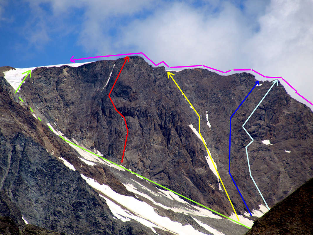
Swiss (left) & Italian (right) Slopes with Western and Southwestern Routes, by sarme
Essential Gear
For High Mountaineering, with rope, axe and crampons.Da Alto Alpinismo, con corda, piccozza e ramponi.
Mountain Conditions
- You can get meteo information at the official site of the Regione Valle d'Aosta:
- Valle d'Aosta Meteo
Books and Maps
- "Guida delle Alpi Occidentali", di Giovanni Bobba e Luigi Vaccarone C.A.I. Sezione di Torino Volume II (parte II), 25 Maggio 1896.
- "Guida dei Monti d'Italia-Alpi Pennine" (Vol. I°) di Gino Buscaini-Club Alpino Italiano/Turing Club Italiano, Luglio 1971 (in Italian).
- "I Rifugi della Valle d'Aosta" di Stefano Ardito, Ed. Guide iter, Febbraio 2003.
 |
 |
 |
- L'Escursionista "Valpelline, Saint Barthélemy" (carta n° 6) 1:25.000.
- C.N.S. "Mont Vèlan", foglio 1366, 1:25.000.
- Kompass "Breuil/Cervinia-Zermatt" Carta turistica 1:50.000.
- I.G.C. Istituto Geografico Centrale "La Valpelline, Ollomont, Saint Barthélemy", (carta n° 115) Map1:30.000.
Important Information
- REGIONE AUTONOMA VALLE D'AOSTA the official site.
- FONDAZIONE MONTAGNA SICURA Villa Cameron, località Villard de la Palud n° 1 Courmayeur (AO) Tel: 39 0165 897602 - Fax: 39 0165 897647.
- SOCIETA' DELLE GUIDE DELLA VALPELLINE Etroubles-Strada Nazionale, n° 13 - Tel +39 0165 78559 - Valpelline-Loc Capoluogo, n° 1 - Tel +39 0165 713502 (AO) Italia.
- A.I.NE.VA. (Associazione Interregionale Neve e Valanghe).
Useful Numbers
- Protezione Civile Valdostana località Aeroporto n° 7/A Saint Christophe (Ao) Tel. 0165-238222.
- Bollettino Meteo (weather info) Tel. 0165-44113.
- Unità Operativa di Soccorso Sanitario Tel. 118.