
|
|
Mountain/Rock |
|---|---|
|
|
25.90228°S / 48.99351°W |
|
|
Download GPX » View Route on Map |
|
|
Matutao/ Tijucas do Sul |
|
|
Hiking, Mountaineering, Bouldering |
|
|
Winter |
|
|
5512 ft / 1680 m |
|
|
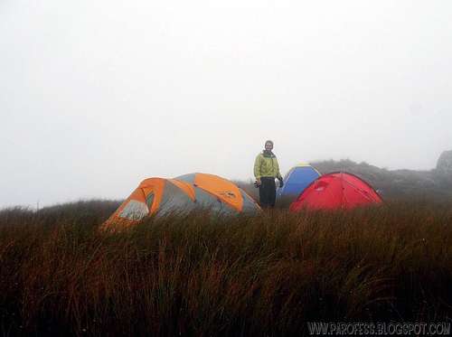
Me at the summit. 1.680m.
Araçatuba Peak has a second funny name here in Brazil, very well known among local mountaineers from Curitiba city, Paraná: Araçapurna. The reason for that funny name is a joke about the famous 8000er Annapurna. A massive mountain in Nepal, 10th highest peak of our beloved planet. Cold as hell. Araçatuba is the highest mountain at the range and because of that nothing stop the wings and storms from south. It is treated as the coldest mountain in Paraná state. At winter time temperature can easily drop to –5°C with a chill of –10°C. Water will froze and the tent will get frosty at morning, covered in white.
So Araçatuba very fast became Araçapurna!
The mountain is very easy to hike, but it’s always good to go at night to avoid the sun hitting the front of the mountain, there are few trees or none (only at the beginning of the trail). By day the heat can be intense and by night very cold. During the winter months is normal to have heavy frosts on the mountain, the soil freezes. There has snowed a few times up there. The walk can take between 2 and 5 hours depending on the hiker condition. At its summit the view is magnificent, and you can see the Guaratuba bay and a small part of Santa Catarina coast. Araçatuba has 1.680 meters and rocky outcrop. Ideal for training before some Andean adventure. A carpet of grass spreads across almost the entire body of the mountain to the summit. Part of the mountain is used as pasture by the owners of a few farms close by.
Getting There
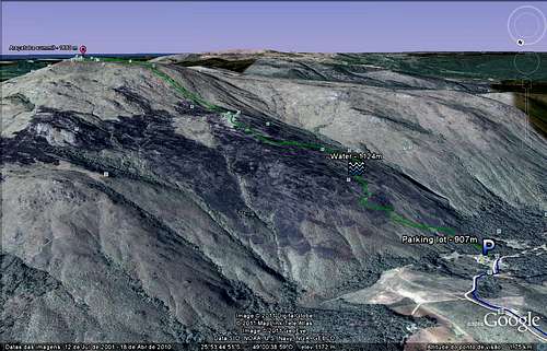
Sat view 1
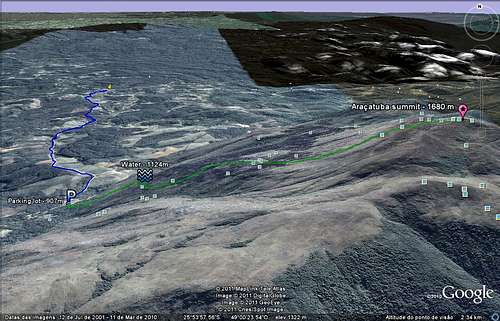
Sat view 2
From Curitiba take the BR376 road to Matutão neighborhood (marked at the kml file for download). Stop the car at the farm with the sign, pay a small fee for the use of the parking lot (R$ 10,00 – about US$ 6.00) and start the wide open trail.
For the first water point – about 5 minutes
For the second and last water point – about 25 minutes up the trail.
The trail itself is very, very easy. Well marked while you’re inside a small forest area, at around 1.150 meters high you’ll get out of the woods and start walking on a grassy trail up. Be careful not to get lost because there is several trails since loads of cows walk around. I can get to the summit in around 2 hours with a backpack. Some people take around 5 hours.
Starting point: 907 m
Summit: 1.680 m
Red Tape
Parking lot at the farm;Well marked trail;
R$ 10,00 (around US$ 6.00) fee.
What’s forbidden:
At all costs, don't make fire or deforest any places. Respect the nature and wildlife please!
Camping
Simple, at the summit. There is plenty of space for aprox. 20 – 25 tents. If you go up at winter, high season, the summit can get very busy! Just bellow the summit ridge there's more space for camping, around 10 tents more. |  |  |  |  |
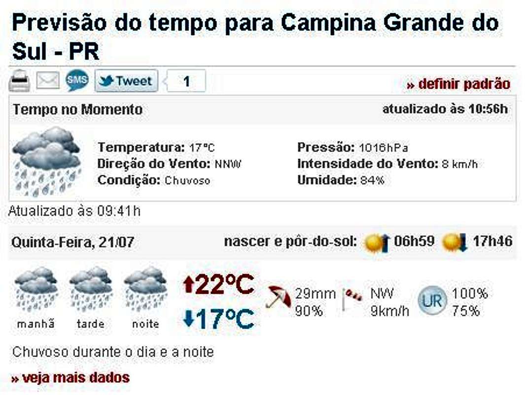
Weather Forecast
You can hike this mountain in all seasons, but in summer there are rains every day. In winter is cold, but the days are clearer. The temperatures going from -10°C to 15°C.Best time to climb: April to September.
Legal Issues
To hike/ climb is a dangerous activity and requires proper equipment and clothing, the owner of this page cannot be blamed by injuries caused to anyone who read this page for its info about the mountain, and eventually got hurt by doing so with reckless behaviour or bad weather conditions.
Paulo Roberto Felipe Schmidt – AKA: PAROFES
External Links
My youtube channel: www.youtube.com/parofes - Now with 270+ videos online!The biggest brazilian website about climbing and mountaineering, for which I'm a columnist: