Cleveland Mountain Standard Routes

Cleveland Mountain Standard Routes

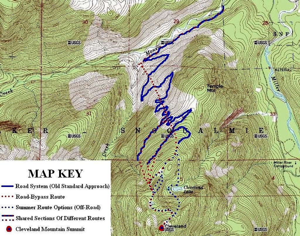
The standard routes for Cleveland Mountain, located in the Alpine Lakes Wilderness of Washington.
------------

SPECIAL NOTES:
The Road-Bypass Route first leaves the road system at the first road switchback. For the Road-Bypass Route, cross over the seasonal stream that is located at the road switchback, and briefly continue following an abandoned road on the other side before turning uphill and off-road with the seasonal stream located to the climbers' leftside (eastside).

Only the Summer Routes have a recommended option of possibly crossing over the top of the knife-edge ridge located due west of Cleveland Lake. Crossing directly over the knife-edge ridge is only recommended during dry periods with no snowpack or ice, such as late Summer/ early Autumn. Most people choose to bypass the knife-edge, with the slope ~200' below its west side perhaps the best recommendation for bypassing the knife-edge section.

There are more route possibilities than what is shown on this map. In one example, during optimum conditions some people might choose to follow the ridgeline the entire way to the summit once the ridgetop is initially reached from the road system. In another example, some people might choose to ascend the steep and cliffy east slopes.
------------

Route map created on December 20, 2011.

Redwic
on Dec 20, 2011 10:49 pm
Image Type(s): Alpine Climbing,  Hiking
Image ID: 766762

Comments

Post a Comment
Viewing: 1-2 of 2
gimpilator

gimpilator - Dec 21, 2011 3:52 pm - Voted 10/10

Nice Work

For a smaller peak, this one sure seems to give people a lot of trouble. Thanks for the effort you put into this route information.

Redwic

Redwic - Dec 22, 2011 5:08 am - Hasn't voted

It is all about timing!

This is not a technical peak, or at least does not need to be. I think people underestimate the distance and time involved when following the entire road system. Plus, conditions along the road system might be vastly different than conditions on the upper slopes. Some people (myself included) have also gotten delayed by gnarly conditions at/near the knife-edge ridge section, thinking that section is necessary to traverse over (but it is not).

I created this route map to give people different options and help their success based on available hiking time, route conditions, etc. For many people, the 360-degree summit view might make the effort worthwhile.

Viewing: 1-2 of 2