


-
 3445 Hits
-
 84.82% Score
-
 19 Votes
|
|
Mountain/Rock |
|---|---|
|
|
45.86680°N / 7.86882°E |
|
|
Hiking |
|
|
Spring, Summer, Fall, Winter |
|
|
9928 ft / 3026 m |
|
|
Note
La montagna chiama i suoi figli, ed essi rispondono fedelmente al suo appello… Osvaldo Cardellina, Diario alpinistico, 1964-65 Page texts: @ OsvaldoCardellina "Osva", passed away on May 2, 2022. Page owners: Christian Cardellina e Osvaldo Cardellina. Any updates from September 12, 2022: Antonio Giani, page administrator, friend and climbing companion. Testi della pagina: @ OsvaldoCardellina "Osva", scomparso il 2 maggio 2022. Proprietari pagina: Christian Cardellina e Osvaldo Cardellina. Eventuali aggiornamenti dal 12 settembre 2022: Antonio Giani, amministratore della pagina, amico e compagno di salite. |
Horn Overview Chamois
This small mountain is formed by two main ridges with as many slopes and is located between the Passo dei Salati (2.931m) to the North and the Col d'Olen (2.896m) to Mezzogiorno. Beautiful views across the Alpine arch and in particular on Monte Rosa with the two neighboring Lyskamms.

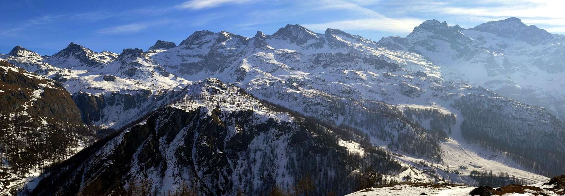
General Pano of Monte Rosa Southern Side from South-southeast or Corno del Camoscio, by emilius
Questa piccola montagna é formata da due creste principali con altrettanti versanti ed é collocata tra il Passo dei Salati (2.931 m) a Settentrione ed il Col d'Olen (2.896 m) a Mezzogiorno. Belle vedute su tutto l'arco alpino ed in particolare sul Monte Rosa con i due vicini Lyskamms.
Landscape of Monte Rosa Southern Appendanges from Col d'Olen (2.896m; to the extreme left), by emilius
Getting There
BY CAR:
- From TORINO, MILANO, etc: Motorway A5. Exit at IVREA or Quincinetto (PIEDMONT).
- From IVREA Town: in West (Southern side) to Pont Saint Martin, Verrès, Châtillon, Nus, Aosta in West and to Gignod, Valpelline, Oyace and Bionaz Municipalities in Northeast from Aosta Town. From Courmayeur Resort: in East-southeast (Norheastern side) to Aosta, Gignod, Valpelline, Oyace, Bionaz Municipalities in Northeast and to Nus, Châtillon, Verrès, Pont Saint Martin Communes to South-southeast.
- From Pont Saint Martin towards Gressoney or Lys Valley From Pont Saint Martin (345m), with Regional Road in Gressoney Valley, to Gressoney La Trinitè (1.468m); from this, through dirt roads and paths in East, up to the Upper Bettolina Pass (3.058m); also in West to Gabiet Loch (2.363m) and from this, with path, to Corno del Camoscio (3.026m).
- From FRANCE: through the Mont Blanc Tunnel to Entrèves-crossroads to Vény/Ferret Valleys - Courmayeur. By Little Saint Bernard Pass, closed since November until half May to La Thuile Valley - Pré Saint Didier - Courmayeur. It is not necessary to take Motorway A5: you can drive on SS.26, in the direction of AOSTA - IVREA - TURIN.
BY PLANE:
- Aeroporto "Corrado Gex" Saint Christophe (Aosta).
Route from Aosta's Valley
Corno del Camoscio (3.026m) from Gabiet Loch (2.363m) Approach from dirt road towards the lake: from Gressoney La Trinité, at the end of the Gressoney Valley, to Parking between Fòhré/Enge (1.798m) small Villages (*Departure of a first Chair Lift to alp 1.910 meters and from this an other chair to dirt road immediately below Gabiet Loch), with Main Road; also to Obrò de Jòlò (1.837m). From alternative (+; 1.801m; signal no transit and parking) just before, through dirt road in Southeast, towards Montery, Tschòcke (1.926m) Pastures, alternatives 1.941m, 1.989m, Recka (2.131m), Shéttò Alpages, near Lys Refuge (2.339m; **arrival Cableway from Staffal). From this briefly to
a) - Gabiet Refuge and Loch (2.370m, 2.363m; T; 0h'10); from Lys Refuge, through dirt road in North, to neighbor Ponte Shelter (2.388m) and, doubling West the Schwoarzehòre (2.710m), through path on moraines in East, to
b) - Zube Pass (2.871m), between Corno Rosso or Rothòre (3.023m) and Punta Straling (3.115m). Also continue in North-northeast, always through dirt road, to
c) - Salati Pass (2.931m), between Stoleberg (3.202m) and Corno del Camoscio (+; 3.026m). You and still, through dirt road in Northeast, towards the
d) - pond 2.721 meters and d'Olen Hill (2.880m), above Guglielmina and Città di Vigevano Refuges (2.863m), now immediately but completely in Piedmont Region. From the both hills eaily to Corno del Camoscio (E/F; 4h'00/4h'30 from Fòhré/Enge or from Obrò de Jòlò Villages; 1h'45/2h'15 from Gabiet Loch or from the Gabiet, Lys, Ponte Shelters, all three in the same vicinity of the lake).
![]()
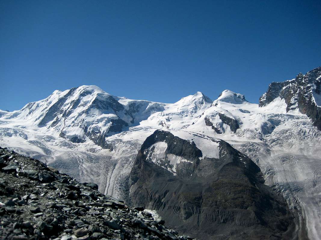
Pano of Southern Monte Rosa Group from South-southeast, by hiltrud.liu
Corno del Camoscio (3.026m) dal Lago Gabiet (2.363 m) Avvicinamento dalla poderale per il lago: da Gressoney La Trinité, al termine della Valle di Gressoney, al Parking tra i Villaggetti di Fòhré ed Enge (1.798 m) (*Partenza del primo troncone della Funivia verso l'alpeggio a 1.910 metri e da questo tramite il successivo verso la poderale immediatamente al di sotto del Lago Gabiet), per mezzo della Strada Principale; oppure in direzione di Obrò de Jòlò (1.837 m). Dal bivio (+; 1.801 m; divieto di transito e parcheggio) appena prima, con poderale a Sudest, verso le Alpi Montery e Tschòcke (1.926 m), biforcazioni 1.941 metri e 1.989 metri e gli Alpeggi di Recka (2.131 m) e Shéttò, presso il Rifugio del Lys (2.339 m; **arrivo della Funivia da Staffal). Da questo in breve tempo con diverse possibilità verso il
a) - Rifugio del Gabiet e Lago (2.370 m, 2.363 m; T; 0h'10); dal Rifugio del Lys, tramite poderale verso Nord, verso il vicino Rifugio Ponte (2.388 m) e, doppiando ad Ovest il Schwoarzehòre (2.710 m), tramite sentiero ad Est nelle morene, al
b) - Passo di Zube (2.871 m), posto tra Corno Rosso o Rothòre (3.023 m) e Punta Straling (3.115 m). Oppure continuare verso Nord-nordest, sempre a mezzo di poderale, verso il
c) - Colle dei Salati (2.931 m), collocato tra lo Stoleberg (3.202 m) ed il Corno del Camoscio (+; 3.026 m). Od ancora, con poderale in Nordest, verso il
d) - laghetto 2.721 metri ed il Col d'Olen (2.880 m), al di sopra dei Rifugi Guglielmina e Città di Vigevano (2.863 m), adesso immediatamente ma completamente in Regione Piemonte. Da entrambi i colli e facilmente al viciniore Corno del Camoscio (E/F; 4h'00/4h'30 dai Villaggi di Fòhré/Enge o da Obrò de Jòlò; 1h'45/2h'15 dal Lago del Gabiet oppure dai Rifugi Gabiet, Lys e Ponte, tutti e tre nelle vicinanze del lago).
![]()
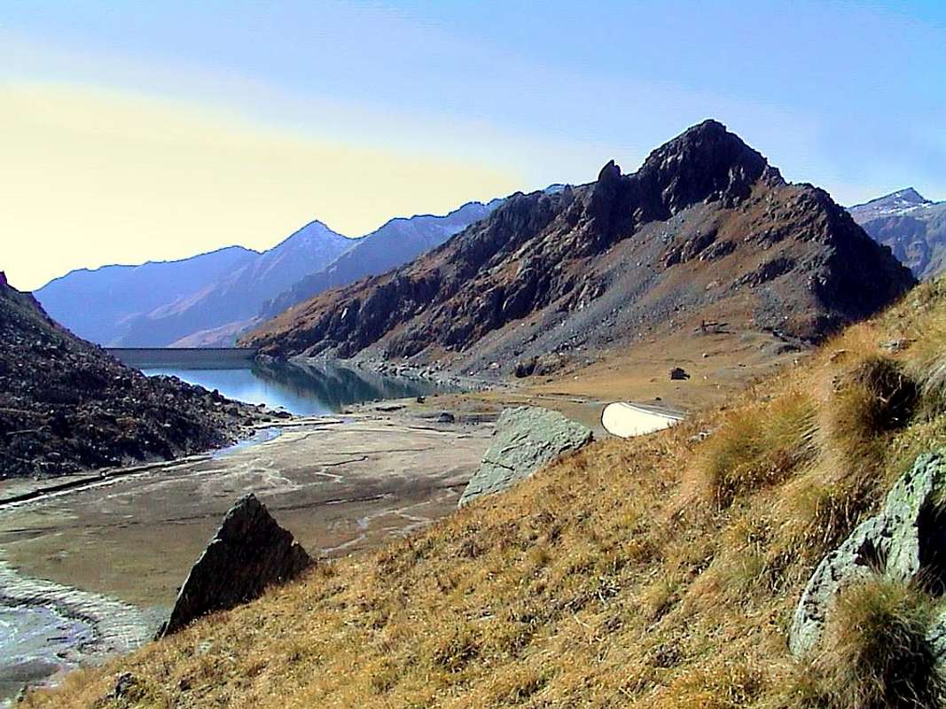
Near the Gabiet Refuge (2.370m), by emilius
Equipment & Difficulties
This route can be considered EE/F for the crest watershed.L'itinerario è da classificare in EE/F per la cresta spartiacque.
 |
 |
 |
 |
 |
For Hiking or by Snowshoes.
Da Escursionismo oppure con Racchette da neve.
Campings
Remember that free camping is forbidden (except for emergency reasons, over 2.500m, from darkness until dawn).Mountain Conditions
- You can get meteo information at the official site of the Regione Valle d'Aosta:
- Valle d'Aosta Meteo
Books and Maps
BOOKS:- "Guida delle Alpi Occidentali" di Giovanni Bobba e Luigi Vaccarone C.A.I. Sezione di Torino Volume II (parte II), 25 Maggio 1896.
- "A piedi in Valle d'Aosta" (Vol. 2), di Stefano Ardito, Ed. Guide iter, Giugno 2004.
- "Guida dei Monti d'Italia" Monte Rosa di Gino Buscaini - Club Alpino Italiano/Turing Club Italiano, Maggio 2002 (In Italian).
 |
 |
 |
- Meridiani Montagne "Monte Rosa" Carta 1:50.000 con carta di dettaglio 1:20.000.
- L'Escursionista "Val d'Ayas Val di Gressoney Monte Rosa" Carta dei sentieri (n° 8) 1:25.000.
- Studio F.M.B. "Cervino Monte Rosa" Bologna 1:50.000.
- I.G.C. Istituto Geografico Centrale Torino "Monte Rosa Alagna e Macugnaga" (n° 10), 1:50.000.
- Kompass "Breuil/Cervinia-Zermatt" Carta turistica 1:50.000.
- I.G.C. Istituto Geografico Centrale Torino "Cervino e Monte Rosa" 1:50.000.
Important Information
- REGIONE AUTONOMA VALLE D'AOSTA the official site.
- SOCIETA' DELLE GUIDE ALPINE DI GRESSONEY the official site.
- FONDAZIONE MONTAGNA SICURA Villa Cameron, località Villard de la Palud n° 1 Courmayeur (AO) Tel: 39 0165 897602 - Fax: 39 0165 897647.
- A.I.NE.VA. (Associazione Interregionale Neve e Valanghe).
Useful numbers
- Protezione Civile Valdostana località Aeroporto n° 7/A Saint Christophe (Ao) Tel. 0165-238222.
- Bollettino Meteo (weather info) Tel. 0165-44113.
- Unità Operativa di Soccorso Sanitario Tel. 118.