
|
|
Mountain/Rock |
|---|---|
|
|
36.75749°N / 121.5041°W |
|
|
Monterey |
|
|
Hiking |
|
|
Spring, Summer, Fall, Winter |
|
|
3169 ft / 966 m |
|
|
Overview
Previously named Gabilan Peak, the peak is now named Fremont Peak after John C. Fremont, an American military officer and later one of California's first U.S. Senators. The word Gabilan means "Hawk" in Spanish, of which one will see many from the peak. The peak itself is currently part of the Fremont State Park. The area is rich in early Californian history; most notable for Fremont's decision to raise the American Flag on the summit despite the fact the California was part of Mexico at the time. In the ensuing days there was much tension between Fremont's camp and the Mexican authorities in Monterey, the Capital. More information on Fremont and the history of these events can be found at Hawks Peak and Wikipedia
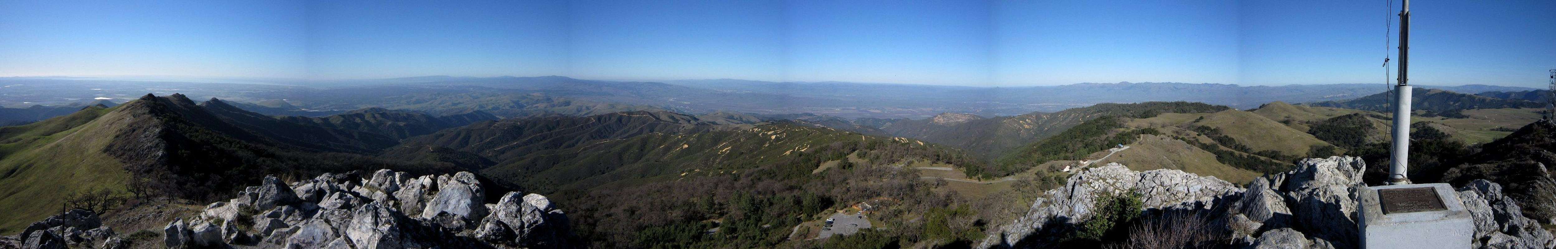
The hike to the summit is along a very easy ½ mile trail that ascends a mere 300 feet. There are two routes to the summit, both beginning at the park's upper parking area. The trail contours around the north side of the peak swinging over a saddle along the east/west ridge then ascends the peak. There is also an access road serving the lovely communications equipment just off the peak's SW side. The view from the summit is stunning. It encompasses the Monterey Peninsula and Bay, the south bay mountains, the Diablo range from Pacheco Peak to those southward and the San Benito Valley.
  |
On the summit there is a plaque commemorating Fremont's raising of the American Flag on the peak.
 Summit Plaque for John C. Fremont.
Vegetation on Fremont Peak's northern slope consists of manzanita, toyon and scrub oak, while the exposed southern slope is covered with grassland that is bright green with wildflowers in spring and golden brown in summer. On the upper ridges eagles, hawks and turkey vultures can be seen.
 Trail on the northern slope.
 Trail on the southern slope.
Getting There
Directions to the parkFrom Highway 101 north of Salinas and south of Gilroy, exit on Highway 156 and travel miles to the town of San Juan Bautista. Take the signed turnoff for the state park on San Juan Canyon Road. Continue on for 11 miles to the road's end at Fremont Peak State Park. Park in the upper lot.
The Hike
Walk up the road, located at the south on the parking lot, for a short distance then join the signed trail to the peak. The trail contours around the north slopes of the mountain. There are fine views of Monterey Bay and the surrounding valleys. The path climbs to a saddle and turns to the left and climbs the summit trail. There are a few easy sections that need to be scrambled and a short staircase leading up to the summit block.
 Stairs leading to the summit block.
 Summit area.
Red Tape
The peak is within the Fremont State Park. There is currently a $6.00 access fee for the park. Camping is only allowed at the park run campground. The park is open year round from 8:00 am to ½ hour after sunset.Camping
The park has a 20 site campground located at the lower parking lot. There are picnic benches, vault toilets, drinking water and oak tree shaded sites with fine views of the peak and surrounding countryside. Reservations can be made by calling (800) 444-7275 or visiting Reserve America Online.Contact Info, Hours and Current Conditions
Contact InfoPark Information
831-623-4255
Operating Hours
Open year round
Day use hours
8:00am to one-half hour after Sunset.
Observatory Programs
April through October
on moonless Saturday evenings starting at 8:00pm.
Conditions
Bob Burd - Jan 23, 2011 10:53 pm - Hasn't voted
GabilanReferences to "Gablian" should read "Gabilan". "Gavilan" is spanish for hawk, and "Gabilan" is either an archaic Spanish spelling or possibly an English misspelling.