


Day Hiker - Feb 1, 2006 12:53 pm - Hasn't voted
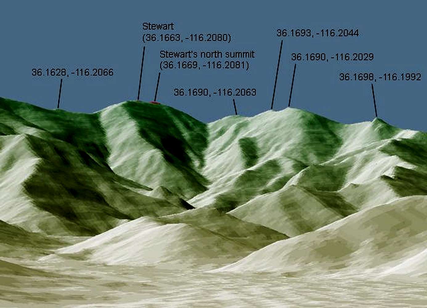
Re: Incredible TechnologyRegarding the technology, my program is only as good as the USGS data source. As I was generating images of Stewart from various viewpoints, it is rather interesting what I came across. I noticed a slight error in the topo data near Pahrump Peak. I generated an image from the perspective of this shot, and I noticed that in the generated image, the peak in the foreground was noticeably higher than it is in reality. I have never been there, but the actual photo shows reality correctly, of course. In the photo, the peak to the north is obviously a little bit lower than the photographer's viewpoint. So I looked at Pahrump Peak on Topozone, and saw that while Pahrump is listed as 1749.6m, the point to the north-northwest is listed as 1751m. Based on the photo, at least one of these numbers must be incorrect.
I have noticed in the past that the data I get from USGS correspond to the data shown on Topozone; they appear to be from the same source. So there is obviously a small but noticeable error in the data for the summit of either Pahrump Peak or the peak to its north or both.
So while the data are generally accurate enough to render an approximation of a topographical feature, sometimes small errors in the data become apparent when looking at distinct features, like the lower summit of a nearby peak, as in the case of the peak north of Pahrump Peak.

Dean - Feb 1, 2006 3:49 pm - Voted 10/10
Re: Incredible TechnologyWell done Mike. Neat, neat stuff.

MoapaPk - Feb 3, 2006 7:03 pm - Hasn't voted
Re: Incredible Technology"while Pahrump is listed as 1749.6m, the point to the north-northwest is listed as 1751m."
DayHiker--
In NV at least, the USGS changed the definition of sea level around 1998 to 1999, which was after most topo maps were made (They stopped using NAD27 as a reference, went to GEOID99, yada yada yada). If you can get the full PID record, you'll often find that a meter or so was added to the accepted benchmarked "heights" about 1998-1999.
Can you retrieve the full PID record from the USGS or Geodetic Survey? I'm sure there is a way to find the PID sheets on the web (I've done it before), but I can't find them (before I get back to my day job).
Here's an example that documents the recent change for Castle Peak, NV:
1 National Geodetic Survey, Retrieval Date = APRIL 30, 2002
FS1378 ***********************************************************************
FS1378 DESIGNATION - CASTLE
FS1378 PID - FS1378
FS1378 STATE/COUNTY- NV/CLARK
FS1378 USGS QUAD - MC CULLOUGH MOUNTAIN NE (1989)
FS1378
FS1378 *CURRENT SURVEY CONTROL
FS1378 ___________________________________________________________________
FS1378* NAD 83(1994)- 35 38 57.33871(N) 115 02 56.50049(W) ADJUSTED
FS1378* NAVD 88 - 1488.0 (meters) 4882. (feet) VERTCON
FS1378 ___________________________________________________________________
FS1378 LAPLACE CORR- -3.58 (seconds) DEFLEC99
FS1378 GEOID HEIGHT- -28.53 (meters) GEOID99
FS1378
FS1378 HORZ ORDER - THIRD
FS1378
FS1378.The horizontal coordinates were established by classical geodetic methods
FS1378.and adjusted by the National Geodetic Survey in June 1998.
FS1378
FS1378.The NAVD 88 height was computed by applying the VERTCON shift value to
FS1378.the NGVD 29 height (displayed under SUPERSEDED SURVEY CONTROL.)
FS1378
FS1378.The Laplace correction was computed from DEFLEC99 derived deflections.
FS1378
FS1378.The geoid height was determined by GEOID99.
FS1378
FS1378; North East Units Scale Converg.
FS1378;SPC NV E - 8,099,889.310 248,382.749 MT 0.99992884 +0 18 41.1
FS1378;UTM 11 - 3,946,800.472 676,622.818 MT 0.99998443 +1 08 14.5
FS1378
FS1378|---------------------------------------------------------------------|
FS1378| PID Reference Object Distance Geod. Az |
FS1378| dddmmss.s |
FS1378| CASTLE RM 2 4.599 METERS 11000 |
FS1378| CASTLE RM 1 4.438 METERS 35642 |
FS1378|---------------------------------------------------------------------|
FS1378
FS1378 SUPERSEDED SURVEY CONTROL
FS1378
FS1378 NAD 83(1992)- 35 38 57.33663(N) 115 02 56.50203(W) AD(1991.35) 3
FS1378 NAD 83(1992)- 35 38 57.33803(N) 115 02 56.50071(W) AD( ) 3
FS1378 NAD 83(1992)- 35 38 57.33777(N) 115 02 56.50203(W) AD( ) 3
FS1378 NAD 83(1986)- 35 38 57.33772(N) 115 02 56.49095(W) AD( ) 3
FS1378 NGVD 29 - 1487.1 (m) 4879. (f) VERT ANG
FS1378
FS1378.Superseded values are not recommended for survey control.
FS1378.NGS no longer adjusts projects to the NAD 27 or NGVD 29 datums.
FS1378.See file dsdata.txt to determine how the superseded data were derived.
FS1378
MoapaPk - Feb 3, 2006 7:34 pm - Hasn't voted
Re: Incredible TechnologyOK, here I am replying to myself again.
The 1749.6 meter point is for an actual monumented benchmark, surveyed against real ground data. I would guess it has probably "gained" about a meter since the last GEOID recalc, but that change should "float all boats".
The 1751 point is a spot elevation, and given that the map is only provisional, I would guess it was never checked, and was determined purely by aerial photogrammetry. That would give it an error of +/- 5 meters 1 sigma. It also appears to be on a different USGS quad from the "Pahrump" benchmark (not so sure about this, just looking at the red suture lines), and the aerial photographs may be from a totally different series.
Want to have some fun? Check the topozone maps for Whitney Portal, 1:24000!


Comments
Post a Comment