
|
|
Mountain/Rock |
|---|---|
|
|
35.49976°N / 83.62134°W |
|
|
Swain |
|
|
Hiking |
|
|
Spring, Summer, Fall, Winter |
|
|
5190 ft / 1582 m |
|
|
Overview
High Rocks is a peak in Swain County NC (Note there is at least one other peak known as High Rocks in NC located in Yancey County). Swain's High Rocks is located deep in the Great Smoky Mountains National Park standing over Lake Fontana. High Rocks stands at 5,190 feet tall and holds 710 feet of prominence making it a peak of some interest to NC and/or southeast peakbaggers. High Rocks also holds several unique attributes. The peak itself holds a debilitated cabin that was in place for a fire watch attendant. The fire tower itself has been removed, only concrete pedestals remain. Approaching this point there's also a delightful set of stone steps. Not on the peak itself, but on the most direct route beginning from Lakeview Dr. (AKA the road to nowhere) the trail goes through a tunnel.
Getting There
Getting Where? High Rocks can technically be accessed by any trail that meets the Appalachian Trail. Being within the Great Smoky Mountains National Park, which has a great trail system, even locally there are many options, but even the shortest requires nearly 20 miles of total hiking car to summit to car.
For the shortest route you would park at the Road to Nowhere Tunnel near Bryson City NC. Locally this peak may also be approached from the Cades Cove Area, Clingman's Dome Parking (when the road is open), and probably several others.
Route
Similar to in the "Getting There" section there are many routes that could allow you to reach this peak.
The most Direct: Beginning at the end of Lakeview Drive start on the Lakeshore Trail (the Eastside Trailhead) follow the Lakeshore Trail for 3 miles. There are a few trail junctions in this three miles, but they're typically well signed. This three miles is relatively gentle and actually loses elevation overall. At the three mile mark is the first campsite you'll reach, camp #74, Lower Forney. Here you'll also come up to Forney Creek a wide raging creek at this point. Lakeshore continues to the left (south) here, but to head to High Rocks take a right (north) onto Forney Creek Trail.
The time on Forney Creek Trail is brief, lasting a third of a mile and walking upstream by Forney Creek. The first trail junction after getting on Forney Creek Trail is with Bear Creek Trail, to the left.
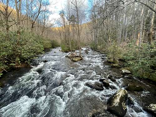
Bear Creek Trail is the main trail of this route, you'll follow it for approximately 4.8 miles. The trail immediately crosses Forney Creek on a wide wooden bridge just below the confluence of Forney and Bear Creeks (pictured above) then soon crosses Bear Creek on another wooden bridge. The trail continues following Bear creek for the first 2.8 miles gaining elevation at an easy pace. At the 2.8 mile mark you reach camp #75 Poplar Flats. You cross over Bear Creek via a bridge 2 or 3 more times in this distance. The trail then leaves Bear Creek for the final two miles on the trail and gains elevation more agressively at roughly 1,000 feet/mile. After this two miles you tee into Cool Springs Gap Trail, take a left.
The time on Cool Springs Gap is very brief, only an easy 0.3 miles where you reach the spur to High Rocks on the right.
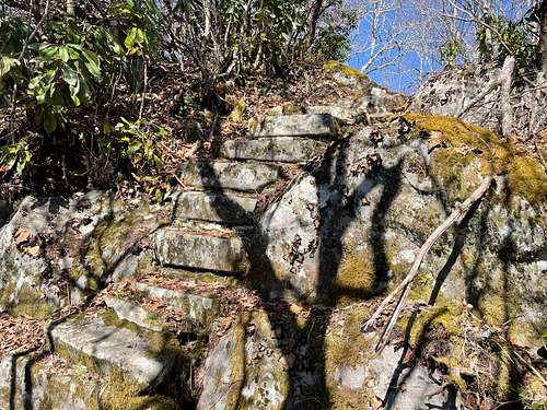
On the spur to High Rock the sign reads 0.4 miles, but I think it's just a bit shorter at 0.3 miles. The trail is gentle to begin with, but gets steeper at the top. First you reach the stone stairs:
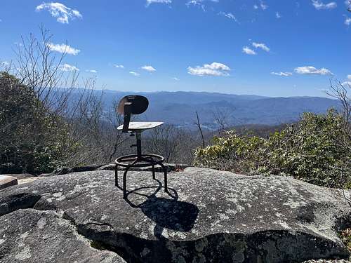
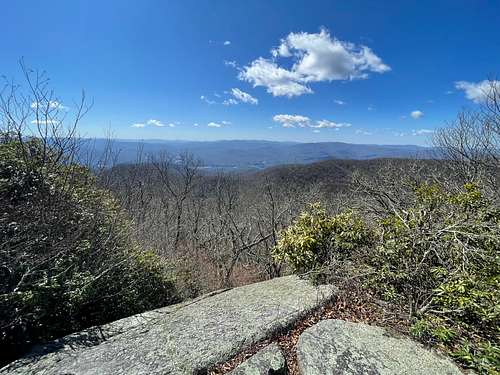
Then you reach the only vista of the day at the top of High Rocks with the chair from the attendant cabin sitting on the rocks:
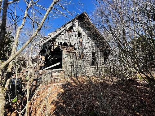
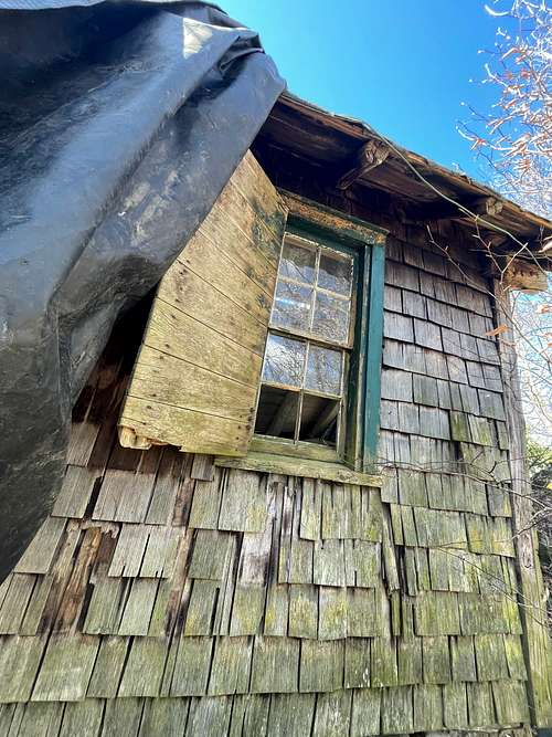
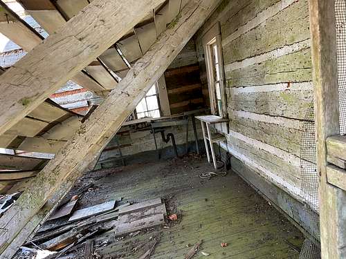
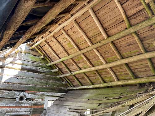
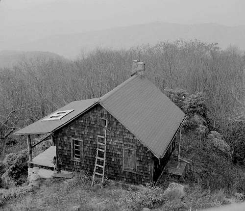
Just past the vista is the cabin in terrible condition, picture taken on 3/26/2022:
Other Routes:
I would expect the next most common route would be to approach from the Appalachian Trail (AT). This Approach would split off the AT onto the Welch Ridge Trail near the Silers Bald Shelter. From the AT the Welch Ridge it is approximately 7.3 miles to meet at the Cool Springs Gap Trail, the same place the Bear Creek Trail ties into Cool Springs Gap.
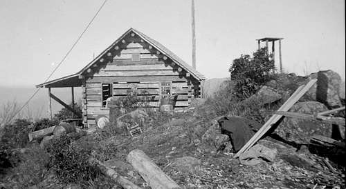
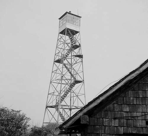
Lookout Tower and Cabin
High Rocks once held a fire tower and the attendants cabin still sits near the top, though it's condition is terrible. I intend to research these items and add more information in this section.
An Artilcle from the Asheville Citizens Times on May 8th, 2016 titled Nature Journal: Magical journey to Smokies' High Rocks suggests the tower was built in the 1930s by the Civilian Conservation Corps and remained until the early 1990s. Other articles by the same author state the cabin, as expected, was built around the same time as the fire tower in the 1930s.
Cabin Pictures as of 3/26/2022:
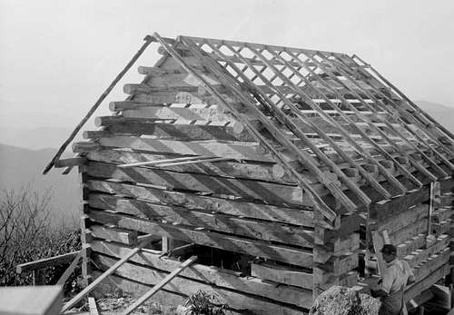
Old Cabin and Tower Photos
The photos below were found on https://openparksnetwork.org/ . These were each labeled High Rocks Great Smoky Mountains, but I wasn't sure. I looked closely and believe the windows are the same as what were in my pictures, plus the total number of struts is 7 on one side, 4 full 3 eave only, matching what I have in the picture from my hike. Now trusting the cabin photos are correct I assumed the tower photos were also correct.
Red Tape
Beginning in 2023 there is a fee to park anywhere in the Great Smoky Mountain National Park, the permit should be purchased and printed before visiting the park.
Camping in the Great Smoky Mountains National Park is only permitted at designated sites and shelters. Look for additional information about camping on their website. The most direct route passes directly by two campsites described in the route section of this page.
When to Climb
Anytime. There's potential for significant snow in the winter (and perhaps part of fall and spring). Heat could be an issue in the summer.
Camping
Camping in the Great Smoky Mountains National Park is only permitted at designated sites and shelters. Look for additional information about camping on their website. The most direct route passes directly by two campsites described in the route section of this page.
External Links
https://peakbagger.com/peak.aspx?pid=7767