


-
 2394 Hits
-
 77.48% Score
-
 8 Votes
|
|
Route |
|---|---|
|
|
45.67740°N / 7.55476°E |
|
|
Summer, Fall |
|
|
Note
|
La montagna chiama i suoi figli, ed essi rispondono fedelmente al suo appello… Osvaldo Cardellina, Diario alpinistico, 1964-65 Page texts: @ OsvaldoCardellina "Osva", passed away on May 2, 2022. Page owners: Christian Cardellina e Osvaldo Cardellina. Any updates from September 12, 2022: Antonio Giani, page administrator, friend and climbing companion. Testi della pagina: @ OsvaldoCardellina "Osva", scomparso il 2 maggio 2022. Proprietari pagina: Christian Cardellina e Osvaldo Cardellina. Eventuali aggiornamenti dal 12 settembre 2022: Antonio Giani, amministratore della pagina, amico e compagno di salite. |
Overview
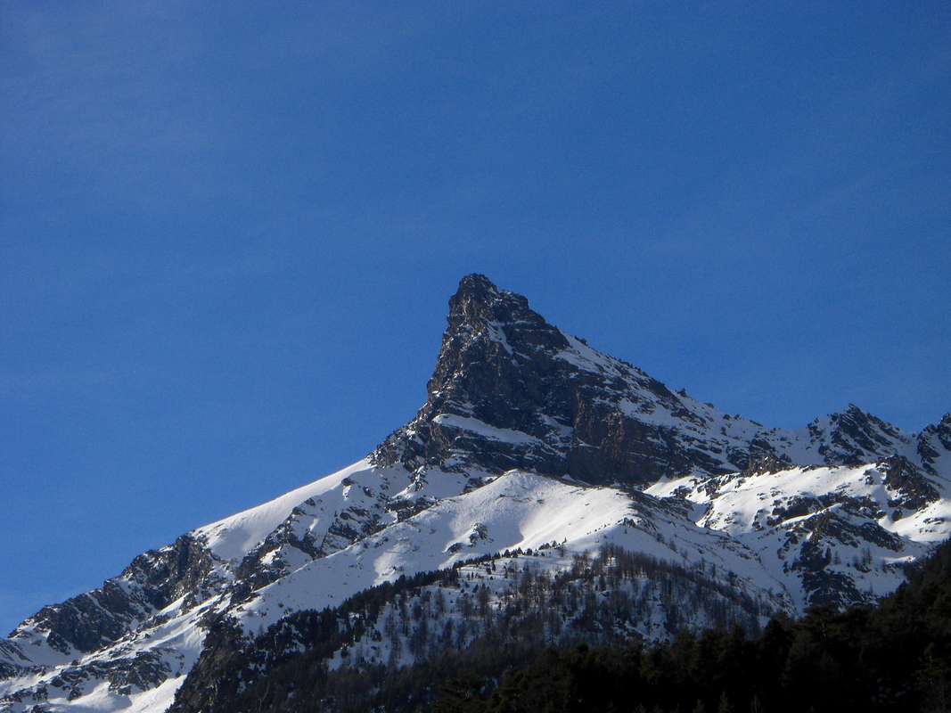
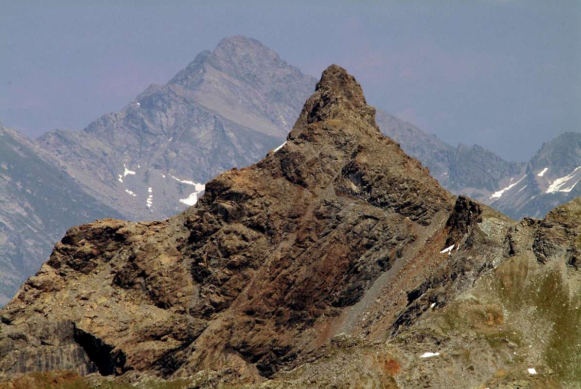
There is a mountain that you think will not climb up again? Exists. Indeed there are many and I happened, in time, not to mention more than having someone climb. "What is that beautiful mountain? Let's get on her?". Embarrassed by the Friends "Watch that we have already done ...". It happens because the time erases everything. Even the most expensive and precious Memories that fade away in the face of everyday life in the depths of a past that increasingly moves away, how does the expanding Universe. It should then make a reverse path for the Memory: instead of starting from afar and were close in more recent time, we start from the latter going back to the same. To the origin of this adventure called Monte Avic or Acute or, because of its sleek lines such as to stimulate Fantasia. Or so I thought at Dawn when going through the train to go to the University of Turin saw the window its silhouette precipitate tilted to the Orient, while in the Evening on the way back I saw his dark profile who fell asleep under the last flashes of light. For a moment, going from Verrès, because the "train effect" makes him even move, like trees and light poles next to the railroad. But I was permanently stopped, while he escaped to go as the return. We'll see tomorrow, so, even if he "wanted" to run away, one day we will perhaps for go up on him (1969-1973) ...
Esiste una Montagna che tu pensi non salirai mai più?
Esiste. Anzi n'esiston molte e m'é capitato, nel tempo, di non ricordare più di averne salita qualcuna. "Cosa é quella bella Montagna? Andiamo a salirla?". Imbarazzo da parte degli Amici "Guarda che l'abbiam già fatta ...". Succede, perché il Tempo cancella tutto. Anche i Ricordi più cari e preziosi che svaniscon di fronte alla quotidianità allontanandosi nei meandri d'un passato che sempre più s'allontana, espandendosi come fà l'Universo. Conviene allora compiere un percorso inverso per la Memoria: invece di partir da lontano per poi avvicinarsi nel tempo più recente, partiam da quest'ultimo andando indietro nello stesso. Fino all'origine di questa Avventura che si chiama Monte Avìc od Acuto, a causa delle sue linee slanciate tali da stimolar la Fantasia. Così almeno pensavo quando all'Alba passando col treno per recarmi all'Università di Torino intravvedevo dal finestrino la sua sagoma precipitare inclinata ad Oriente, mentre la Sera al ritorno notavo loo scuro profilo che s'addormentava sotto gli ultimi sprazzi di luce. Per un attimo passando da Verrès, perché l'"effetto treno" lo fà anche muovere, come per gli alberi ed i pali della luce accanto alla ferrovia. Io invece ero stabilmente fermo, mentre lui sfuggiva all'andata com'al ritorno. Vedremo domani, tanto, anche se ha "voglia di scappare", un giorno può esser che ci salirò (1969-1973) ...
|
|
|
Return Travel Reports since the Past
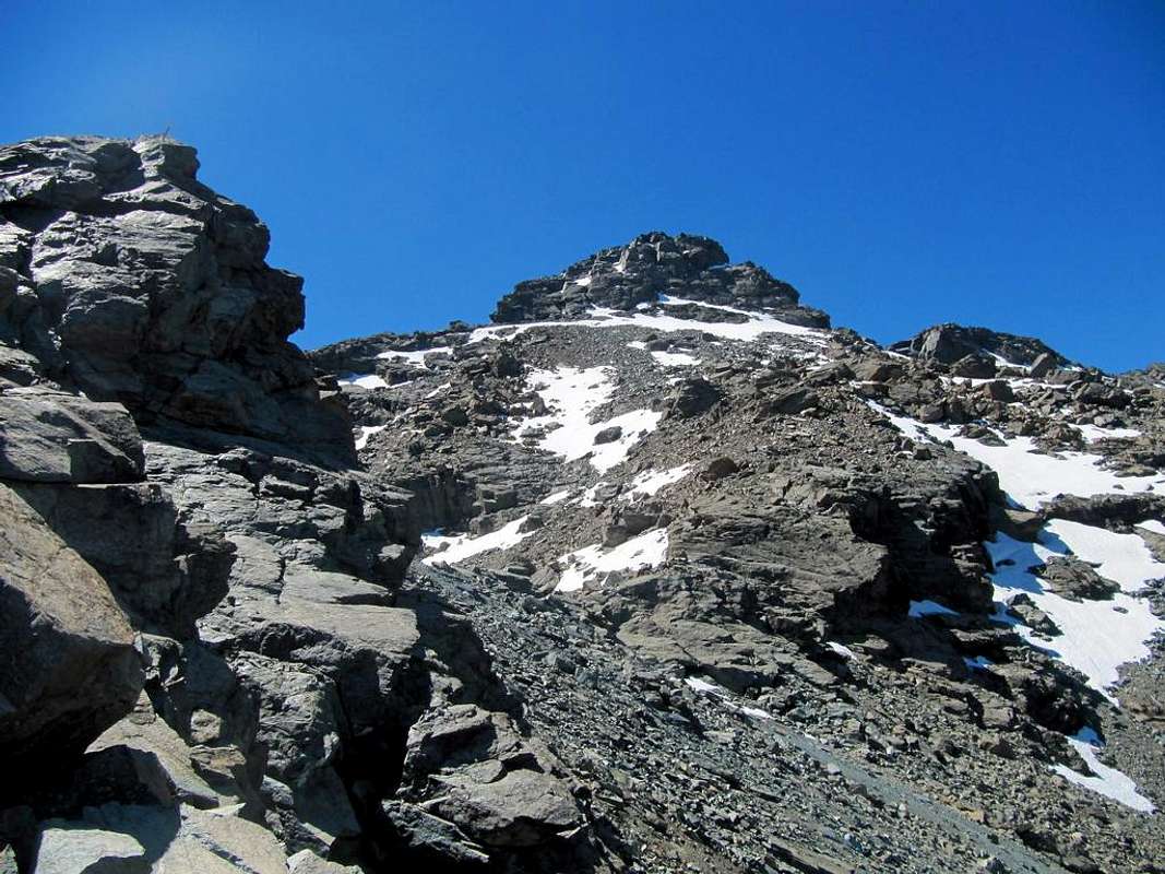
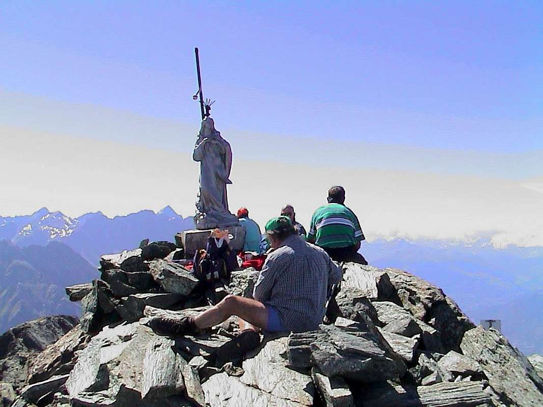
Even today we started from the Village of Voella or Raye Chevrères (1.307m) to return to the Avic in Champdepraz Valley or of the Lakes Vallon; this applies to me, but not for Emilio, Gianfranco, Nicola and Roberto, because for them four it is the first time. Returning up to the past and I think the other times I've climbed this mountain. A sense of rejection over me at the thought of having to face the long sloping mule track leading to Lake Gelato with its iron Mines and copper. No, this time I want to change course as I did in 1993 and from Praz d'Oursi Pasture leave the trail to the South to direct us through a path that is getting smaller in the West towards the Varotta Hill, that the last time we did not reach "cutting upward right" for the North-northeast Slope. A path that becomes increasingly a small path in West towards the Colle Varotta, that the last time we have not reached "cutting straight upwards" for the North Slope-northeast. Reached the Hill, attack the long North Ridge we walk carefully in an integral way until this goes to merge with the North-northeast Face. The Gianfranco Vicentini (the Dean) has made some "whim" on clay to overcome an exposed rocky pinnacle, but the General Roberto Stella immediately and harshly rebuked him and, having tied him, forced him to proceed. In silence. Oh, is a General of the "Alpini" (Alpine Troops), you not can joke! The usual final steps through some chimney of bluish rock and a little damp lead us to the Summit, where Nicola Colajanni (the Judge of the Supreme Court) unflinchingly sits quietly putting to read the "Unità", with General shocked and Emilio Bertona, as usually, eager to get down to fit. I (Apache Guide, so to speak as well baptized me the General) I watch in absolute silence. How do the Apaches. Being that Emilio "quivers", we must begin to decline. I would stay here until the evening and the Judge also, but in a democracy twos is useless: the General decides and so you go down, without anyone breath, because even the Apache Guide is silent, like all Indian Guides. The Gianfranco wants, when the start of the ridge has two or three easy steps but a little exposed, externalize some complaints; just a glance of the General puts to rest and does not dare to make more requests of "trade-union". Incidentally is the hard Law of Life: schoolchildren depend Professors, Professors from Deans and Deans from Generals. "Dura Lex sed Lex".
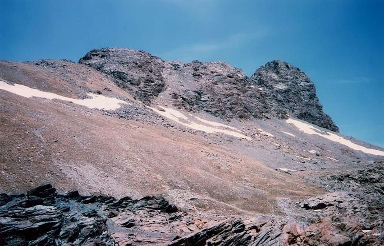
At the end of the enough easy and short Cresta West-southwest and at a narrow fork (2.920/30 meters), a steep gully of rocks with soil leads down to the side of the South-southeast Wall; it is not difficult and you have to be caution not only to pull himself alone the stones. Then gradually flexing in the South you reach the wide Plateau of Rayes Chevrères, where peep a swarm of small ponds.But when under the Col des Rayes Chevrères (2.703m) sees them "anticipate" falling down a gorge in order to gain time, the Guide Apache has a rebellion and begins to go upwards to the North Face of Mount Iverta. She wanted to shout from under Emilio "Wretch tonight I have an important meeting!" (the usual match on television of the A.C. Milan Football Club, which is powered fan). Apache continues its route, so then knows very well that quietly resume their.
At the appropriate time ...
Anche oggi siamo partiti dal Villaggio di Voella (1.307m) per tornar all'Avìc nel Vallone di Champdepraz o dei Laghi; questo vale per me, ma non per Emilio, Gianfranco, Nicola e Roberto, perché per lor quattro trattasi della prima volta. Salendo penso al passato ed all'altre volte che ho salito questa montagna. Un senso di rigetto m'invade al pensiero di dover affrontare la lunga mulattiera inclinata che conduce al Lago Gelato con le sue Miniere di ferro e di rame. No, questa volta voglio cambiare rotta come ho fatto nel 1993 e dall'Alpe di Praz d'Oursì lasciam la mulattiera a Mezzogiorno per indirizzarci tramite un sentiero che diventa sempre più sentierucolo ad Occidente verso il Colle Varotta, che l'altra volta non abbiam raggiunto "tagliando sù dritto" per il Versante Nord-nordest. Raggiunto il Colle, attacchiam la lunga Cresta Nord che percorriamo minuziosamente in modo integrale fino a quando questa và a fondersi col versante Nord-nordest. Gianfranco (il Preside) ha fatto qualche "capriccetto" sulla cresta per scavalcare un esposto pinnacolo di roccia, ma il Generale Roberto l'ha subito aspramente redarguito e, dopo averlo legato, ha obbligato lui a procedere. In silenzio. Oh, é un Generale degli Alpini, mica si scherza! I soliti passaggi finali per camini di roccia bluastra ed un pò umida ci conducon sul Vertice, ove Nicola (il Giudice di Cassazione) senza far 'na piega si siede mettendosi a leggere tranquillamente l'"Unità", col Generale scandalizzato e l'Emilio, come al solito, impaziente di scendere per rientrare. Io (la Guida Apache, per modo di dir visto che così m'ha battezzato il Generale) assisto in assoluto silenzio. Come fan gli Apaches. Essendo che l'Emilio "freme", dobbiam iniziar andar giù. Io starei qua fin a sera ed il Giudice pure, ma in democrazia due a due non serve a nulla: decide il Generale e così si scende, senza che nessun fiati, anche perché la Guida é muta, come tutte le Guide Indiane. Il Gianfranco vorrebbe, quando all'inizio la cresta presenta due o tre facili passaggetti ma un pò esposti, esternar lamentele; basta 'no sguardo del Generale per metterlo a tacere e non s'azzarda più far richieste "sindacali". Daltronde é la dura Legge della Vita: gli scolari dipendono dai Professori, i Professori dai Presidi e Presidi dai Generali. "Dura Lex sed Lex".
Al termine della breve Cresta Ovest-sudovest
e presso una stretta forcellina (2.920/30 metri circa), un ripido canalino di roccette con blocchi in bilico e terriccio scivoloso conduce in basso a fianco della Parete Sud-sudest; non é difficile e bisogna star attenti esclusivamente a non tirarsi da soli addosso le pietre l'un con l'altro. Quindi gradualmente flettendo a Mezzogiorno si raggiunge il largo Plateau delle Rayes Chevrères, dove occhieggiano un nugolo di laghetti, residuo della fusione delle nevi invernali. Ma quando sotto il Colle des Rayes Chevrères li vede "anticipare taliando" la strada e scendendo giù per una gola onde guadagnar tempo nello scendere, la Guida Apache ha un moto di ribellione e incomincia ad andare sù per l'abbastanza ripida Faccia Settentrionale dell'Iverta. Ha voglia di gridar da sotto Emilio "Disgraziato stasera ho una riunione importante!" (la solita partita in televisione del A.C. Milan Football Club del quale é accesissimo tifoso). Ma l' Apache continua nella sua rotta, tanto poi sà bene che li riprenderà appena più al di sotto. A momento opportuno ...
It had been eight long years since we climbed the penultimate time.
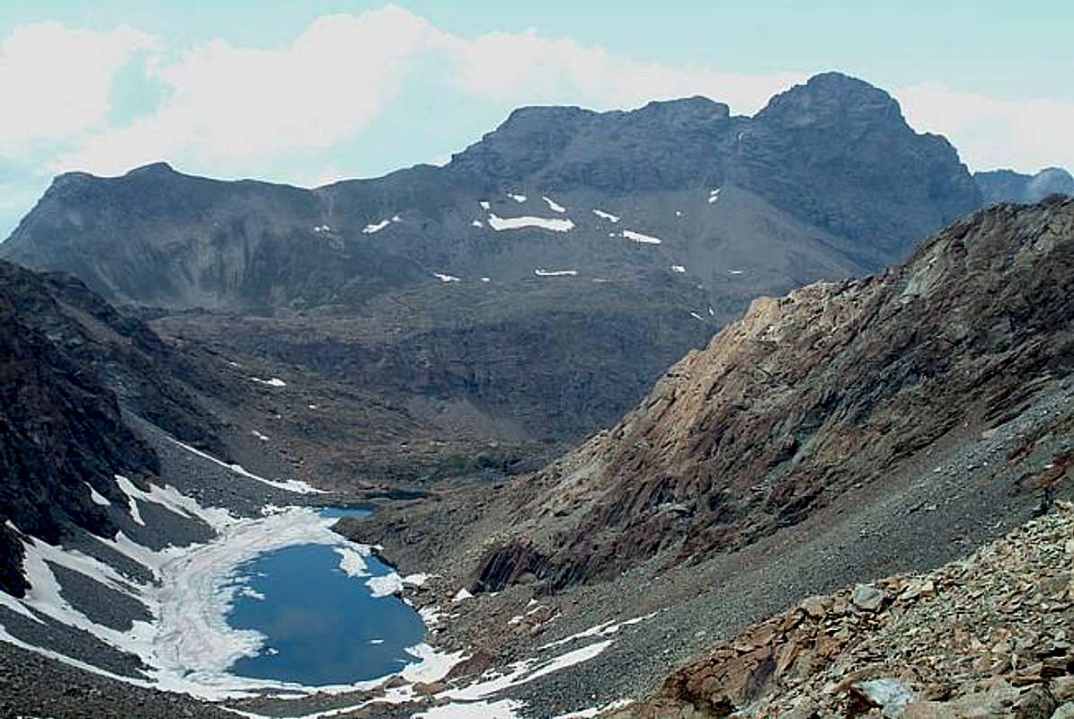
Even then we were a large group and no one, except myself, had never climbed Mount Avic, anywhere. But there's always a first time, and so it happened that the fresh morning when, starting from Voella in six including the very young Demis Freemasons, we head to Monte Aü. For the first time than previous ascents not go up to the Mines of Lake Gelato, but, come to Praz d'Oursì Pasture, we turn West towards the Colle Varotta (2.589m) but not reach the same. After spending the alp get the ruins of the Fiè Pastures (2.080m) and along small hairpin bends, the upper Pian de Fiè (or Fì). Crossing the torrent, at a fresh tiny spring, we turn to the left (Southwest) by entering in a small vallon using a few traces, which leads us to the base of the North-northeast Face of the mountain. Quiet and moderate snowfields lead us soon at the top of a field of boulders that comes out of the snow, while the slopes gradually increase. When these "dampen" against the final wall of about 150 meters, we begin to give the "assault" to her for rocks not difficult, but quite wet. I am in front with Danilo, the others follow suit. "Puffing" on some easy rock by narrows chimneys green-bluish very wet, we are quietly on the summit for the lunch hour. The day is beautiful and makes almost sorry to leave, but it is necessary due to the long descent, who, after having tied for safety Demis, are fast and soon we are at the Plateau des Rayes. A crossing to the right leads to the eponymous hill and around the corner, we reach the beautiful and isolated lake of the same name also called of the Iverta (2.751m), sited now in the Vallon opposite of Savoney, secondary that Fénis-Clavalité; not a leaf moves and only waters flaunt a slight chill wave. The climb on Northern Slope through large blocks that is easy and quickly reach the Summit (2.939m). Watching the Avìc in the foreground seems very far and it seems almost impossible that in such a short time we moved away and almost forgotten the same. Even back remember little or nothing; we see that there was not anything in particular and the cheerful company had mitigated the grueling and tiring always downhill to Voella.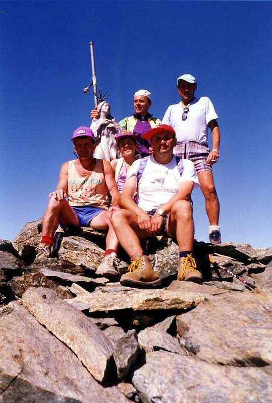
Son passati otto lunghi anni da quando eravam saliti la penultima volta.
Anche allora si era un gruppo numeroso e nessuno, tranne il sottoscritto, aveva mai salito il Monte Avìc, da nessuna parte. Ma c'é sempre una prima volta e così avvenne il quel fresco mattino quando, partendo da Voella in sei compreso il giovanissimo Demis Massoni, ci dirigiamo al Monte Aü. Per la prima volta rispetto alle precedenti ascensioni non salgo alle Miniere del Lago Gelato, ma, giunti all'Alpe Praz d'Oursì, svoltiamo ad Ovest verso il Colle Varotta (2.589 m), ma non lo raggiungiamo. Dopo aver passato l'alpe ed attraversato il torrente, presso una fresca sorgentella, giriamo verso sinistra (Sudovest) entrando tramite scarse tracce in un ripido valloncello, conducenteci alla base del Versante Nord-nordest della montagna. Tranquilli nevai ci portano presto in alto tra una selva di macigni fuoriuscenti dalla neve, mentre le pendenze progressivamente aumentano. Quando queste si "smorzano" contro la parete finale di circa 150 metri, incominciamo a darle l'"assalto" per rocce non difficili, ma alquanto bagnate. Io sono davanti col Danilo, gli altri seguono a ruota. "Sbuffando" per alcuni camini facili di roccia verde-bluastra molto bagnata, tranquillamente siamo sulla Sommità per l'ora di pranzo. La giornata é splendida e fà quasi dispiacere andar via, ma é necessario causa la lunga discesa, che, dopo avere legato per sicurezza Demis, é rapida e ben presto siamo al Plateau des Rayes Chevréres. Una traversata a destra ci conduce all'omonimo colle e, girato l'angolo, raggiungiamo lo splendido ed isolato lago dallo stesso nome od anche detto dell'Iverta (2.751 m), sito ormai nel Vallone opposto di Savoney, secondario a quello di Fénis-Clavalité; non si muove foglia e solo le acque ostentano un leggero brivido ondulatorio. La salita sul Versante Nord tramite grandi blocchi risulta facile e sicura ed in breve tempo raggiungiamo la Sommità (2.939 m). Guardando l'Avìc in primo piano sembra molto lontano e par quasi impossibile che in così breve tempo l'abbiamo allontanato e quasi dimenticato. Del ritorno ricordo poco o quasi nulla; si vede che non era accaduto niente di particolare, mentre la compagnia allegra aveva attenuato l'estenuante e sempre faticosa discesa fino a Voella.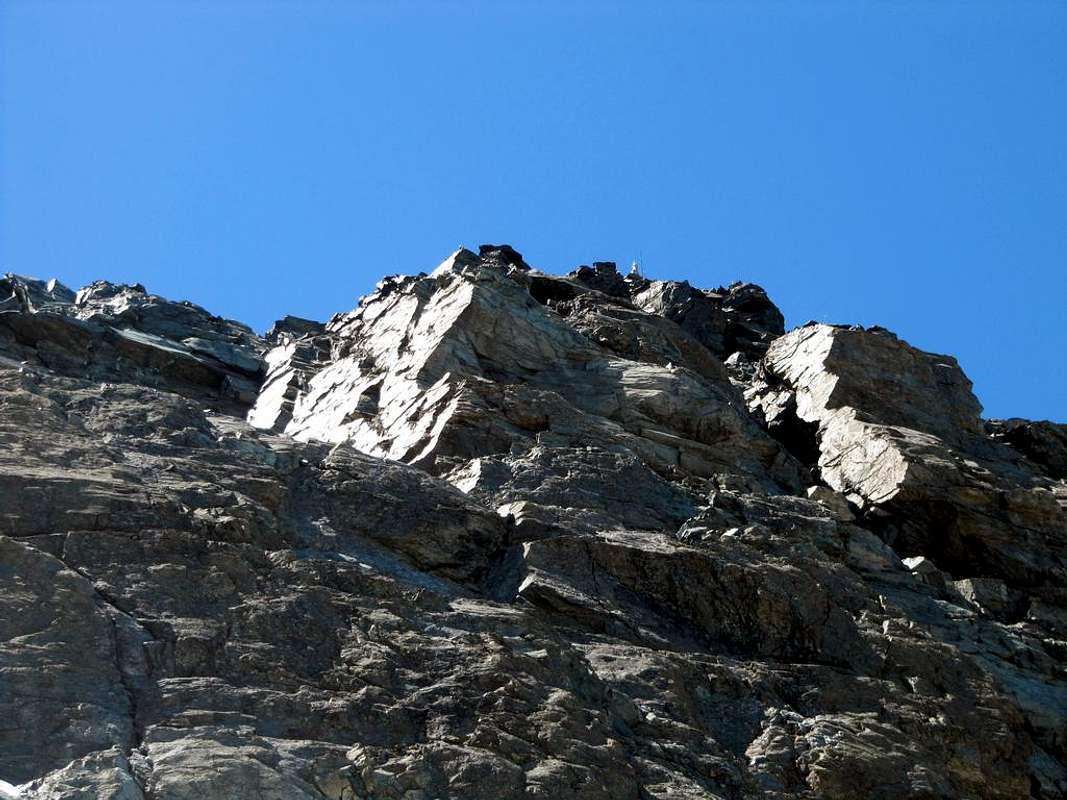
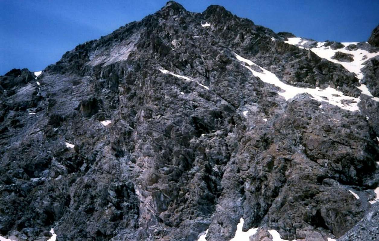
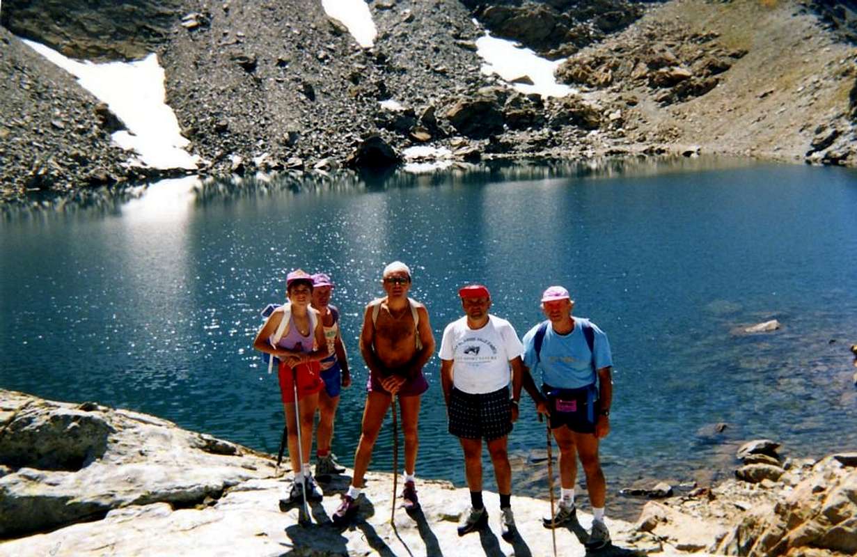
Six years before, instead we went to look for minerals and crystals. Yes, because at these two "Old Wolfs", who are with me, of the Mount Avìc relatively interested, even if they have never gone before. In fact these two are only interested in minerals because are, sissssh, "Crystals Hunters" and rummage in every crack and raise all the stones they find. Spilling the mountains that they pass their forgiveness whenever at least almost one meter high. Only Attila with the Huns could do better or worse, depending on your point of view. A real Mania, incidentally, they say in France, "A chaque fou sa marotte" or to any crazy his mania. Has its mania. Who hunting butterflies, who collect postcards, those who collect stamps, who, who, who ... They collect minerals or, as I say, taking them around, stones. Good thing they were not "Headhunters", but in those days it was not even of Fashion. Already in the previous month of May with two excursions to Mount Barbeston and the Pic de Vòrea had "photographed the mood way to go" of these two, so that the Summit of the latter I found myself alone, while their wandering with my son Christian for walls looking perhaps "the Gold of Klondike", for which thing this time I had made cautiously, prior to the evolution of the situation. I did not have to wait long, the two began to rummage the Avìc from below upwards and from top to bottom. I continued on the edge of the ridge from Raye Chevrères Hill (2.703m) first exceeds the eponymous Summit (2.850m) and then, with a longer straight, goes against the Monte Avic. A vertical rocky jump of about twenty yards I blocked the road to reach the underlying fork 2.920/30 meters about, where he began West-southwest short Ridge, which soon leads to the Summit. Near this point we reunited and quietly photographing reached the Vertex on a beautiful sunny day. I wanted to go to Monte Iverta, but for these two the Iverta interests their even less of Avìc; so, after a quick descent but always analyzing all the stones they met, we go down to the Lake Gelato where their exploring the mines of iron and copper are certainly better gratification. And yet I that I lie on the snowfields at the banks of the lake to enjoy a wonderful, warm Sun ...
Sei anni prima invece eravamo andati a cercar minerali. Si, perché a questi due "Vecchi Lupi"
, che son con me, dell' Avìc gliene frega relativamente, anche se non l'han mai salito precedentemente. In realtà a questi due interessano solo i minerali perché: sissssh, son "Cacciatatori di Cristalli" e rovistano in ogni fessura ed alzano tutti i sassi che trovano. Rovesciano le montagne che quando passano loro perdono ogni volta almeno un metro di altezza. Solo Attila sapeva fare di meglio o di peggio, a seconda dei punti di vista. Una vera e propria Mania, daltronde, dicono in Francia, "A chaque fou sa marotte" cioé ad ogni matto la sua mania. Chi caccia farfalle, chi raccoglie cartoline, chi colleziona francobolli, chi, chi, chi ... Loro collezionano minerali o, come dico io prendendoli in giro, sassi. Meno male che non eran "Cacciatori di Teste", ma al tempo non era ancor di Moda. Già nel precedente mese di Maggio con due Escursioni al Barbeston ed al Pic de Vòrea avevo "fotografato il modo d'andar" di sti due, tanto che sulla Sommità di quest'ultimo m'ero ritrovato da solo, mentre loro con mio figlio Christian gironzolavano per le pareti cercando forse "l'Oro del Klondike", per la quale cosa questa volta m'ero fatto guardingo, in attesa degli sviluppi della situazione. Non dovetti attender molto, che i due incominciarono a rovistare l'Avìc da sotto in sù e dall'alto al basso. Io continuai sul filo di cresta che dal Colle Raye Chevrères dapprima supera l'omonima punta (2.850 m) e poi, con un tratto più rettilineo, si porta contro il Monte Avìc. Un salto verticale d'una ventina di metri mi sbarrava la strada per raggiungere la sottostante forcella 2.920/30 metri circa, dove inizia la Cresta Ovest-sudovest che in breve tempo conduce alla Sommità. Nei pressi di questa ci ricongiungemmo e tranquillamente fotografando raggiungemmo il Vertice in una splendida giornata di sole. Volevo andare al Monte Iverta, ma a questi due dell'Iverta se ne infischiano ancor più dell'Avìc; così, dopo una veloce discesa ma sempre analizzando tutti i sassi che incontravano, andiamo giù al Lago Gelato dove loro esplorando le miniere di ferro e di rame trovano una gratificazione certamente migliore. Eppur io che mi sdraio sui nevai presso le sponde del lago per gustarmi un magnifico, caldo Sole ...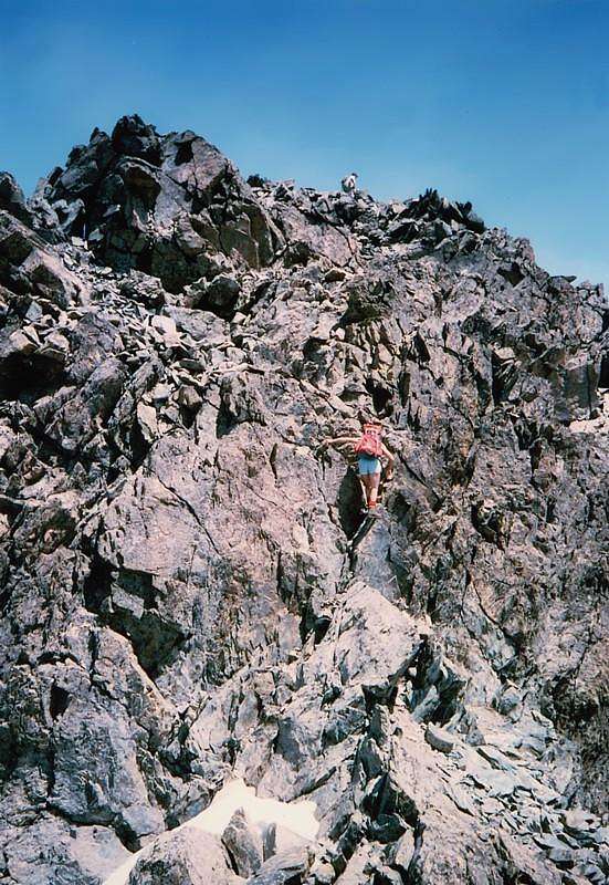
From the first maybe to the last time running away from the Past to the Future through the Present
But which was the first time? It took 10 years, ever since I stopped traveling by train, to go to Monte Avic. The summer began to wane and the days gradually become shorter. The idea, if I remember correctly, is to be attributed to my Friend Marco Cossard, told "Crevassino" (+ Juanuary 16th, 2013) because in that year, going up to Mont Blanc de Tacul had slipped into the crevasse that bisects the Northern Face, having wrong to put the ax to overcome the "mauvais pas", that is from the bottom to the top and not vice versa. With us my son Christian, 10 years-old. I seem to remember that the day was not much good because, with many mists that wandered around the mountains, but those times, taken from the sacred fury of youth, did not look too closely: you always started without checking of any conditions of the time and that's it. With any type of time. The task of searching the route was left to him, great Surveyor and expert reading of Maps, which did not exist at the time if non the tablets of the IGM Scale 1:25.000, there were no "Guides C.A.I. Emilius Rosa dei Banchi Parco del M.Avic" (2005) and even the "Diary Mountaineering Ascents in Aosta Valley 1921-1933" by Amilcare Crétier (1993). But let's do the good that Marco certainly not wrong, although it was the first time we visited this area. You had to go a "little nose" and so we did. Good times for real, total and genuine Adventure!. Not there were problems, the young man followed him in silence and quietly reached Lake Gelato, past the Mines (there had to be careful, because he wanted to get a crack at the pit of letters filled with ice, because he wanted to go exploring. With good manners" him back to reason), traversed the Plateau of Raye Chevrères and the South Slope-Sidest and the crest, or Via Normle, safely reached the Vertex of the Avìc. The pause was brief because "Crevassino" had something else in mind. Honestly had spoken, but not knowing the area the idea of what he wanted to do this "mountain camel" was unclear, if not vague. I know he wanted to get to the Grand Lake under the Glacier and up to it all right there because I had been in 1975 to climb alone the North Edge of the same. But coming from Champorcher through Colle del Lago Bianco. The rest was all entrusted to the personal imagination. As we climbed, we descended so quickly. The Plateau of Rayes and this in crossing the hill, under the Iverta.
Dubbed left the namesake lake, arriving on the Summit was a breeze: front opened, majestic, the two Northern Faces of Mont Glacier which, as mentioned, I knew. But to get up there? Hmmm, I did not like the story too because it seemed to have to cross the Sahara with a series of humps who remembered the dunes of a desert. Uhhmbahhh, hopefully good! We descend from Iverta (2.939m) easily through the South Slope and, passing over to a tiny pond, we reach the Tip Medzove (2.847m), which did not yet this name and we called Punta della Betassa; because a small saddle of 2.800 meters about, at the end of the West Ridge of Mont Belplà or Bel-Plat (2.828/9m; Good Flat), leads to a plateau said of the Betassa where, after another pond, begins to go down a small path (from the saddle now exists a trace, but in those days it was a steep grassy slope of the "Ollina" amongst various rocky bands). We're going to climb even this (if you can think of "Crevassino" not collected!). Going for the easy but jagged ridge in round trip from the saddle. Discarding right Lakes of Leità and the Pass of Mezove (2.614m), below Mont Glacier, you arrive at Grand Lake (2.495m; not there was still the Refuge Letey of the Forest Service). But while we were attracted by the charm, a Little Devil we worked quietly behind his back: the time, uploading the evaporation of lakes, was darkening and predicted an impending storm. Running down the Alp Pisonet, to the Lakes Cornuto (Horned), Nero (Black) and Bianco (White), where now there is the Barbustel Shelter. But then this was the most wild and isolated place in the world. And now? "Crevassino" says "It goes to the North!" What a discovery, if we want to go home ... Meanwhile over us sky rumbles and dark clouds are lowered more and more doing to us increase the pace. Soon it will be dark and we do not even light. The sky sets earlier above the Avìc and then down towards the Iverta and over the Invers of Lake Gelato and you not see longer the point of reference of the Bec l' Espic, yonder above the Lake of the Serva, where we have to get. A match lost by the start up, it becomes a war when the lightning begin to dart over our heads, sending us into total confusion so that, arriving at the junction with the Alp Cousse (2.051m) and seeing the little path that dates back to the Alp Bayet (2.071m), instead of following him go down on the right. He says the ragion why we should not go up but down. Incidentally, not are signals exist in the dark and if exist we do not see; and also the Map in the backpack of "Crevassino" is being withdrawn, being total darkness and having no light. Instead we make a big mistake: we end up in an area of large, polished and levigate blocks alternating with steep rocky banks scroll on which we feel the rivulets of water in the middle to high branches and dense rhododendron. Luckily the vipers will already go to sleep, or at least we hope. With a crossing instinctive and infinite left, climbing a steep rocky rib, we reach the "right path" and soon we are at the Lake of the Serva. From here to Voella everything is easier, despite stumbling occasionally. When we come home now is very late and my wife is anxiously awaiting "But where harbors the child with this black cape?". "Crevassino", maleficent, does not escape the occasion, and this nickname of "Black Pall" her bring back for at least two decades. So learn to mingle in "men affairs". This was my first Monte Avic and so at least I remember ...
Ma quale é stata la prima volta? Ci vollero 10 anni, da quando smisi di viaggiare in treno, per andare al Monte Avìc. L'estate incominciava a declinare e le giornate progressivamente a diventare più corte. L'idea, se non ricordo male, é da attribuirsi al mio Amico Marco Cossard, detto "Crevassino" ( + 16 di Gennaio 2013) perché in quell'anno salendo al Mont Blanc de Tacul s'era infilato nella crepaccia che taglia in due la Faccia Settentrionale, avendo sbagliato ad infilare la piccozza per superare il "mauvais pas", cioé dal basso verso l'alto e non viceversa. Con noi mio figlio Christian, di 10 anni. Mi par di ricordare che la giornata non fosse un gran ché, con molte brume che vagavano intorno ai monti, ma a quei tempi, presi dal sacro furore della giovinezza, non si guardava troppo pel sottile: si partiva sempre e basta. Con qualsiasi tipo di tempo. Il compito di ricerca dell'itinerario era lasciato a lui, Geometra e grande esperto di lettura delle Mappe, che non esistevano all'epoca se non le tavolette dell'I.G.M. Scala 1:25.000, non esisteva la Guida del C.A.I. "Emilius Rosa dei Banchi Parco del M.Avic" (2005) e neppure il "Diario Alpinistico Ascensioni in Valle di Aosta 1921-1933" di Amilcare Crétier (1993). Ma lasciamo fare al bravo Marco che di sicuro non sbaglia, anche s'era la prima volta che visitavamo quest'area. Bisognava andare un poco "a naso" e così facemmo. Bei tempi di vera, totale e genuina Avventura! Non ci furono problemi, il giovane seguiva in silenzio e tranquillamente raggiunto il Lago Gelato, passando accanto alle Miniere (lì dovemmo stare attenti, perché voleva entrare per una fessura a buca da lettere ricolma di ghiaccio, volendo andar giù ad esplorare, ma con le buone" lo riconducemmo alla ragione), traversammo il Plateau delle Rayes Chevrères e per il Versante Sud-sidest e la cresta, o Via Normle, tranquillamente raggiungemmo la Sommità dell'Avìc. La sosta fu breve perché "Crevassino" aveva ben altro in testa. Onestamente ne aveva parlato, ma non conoscendo la zona l'idea di cosa volesse far sto "cammello di montagna" era poco chiara, se non vaga. Sò che voleva raggiungere il Gran Lago sotto al Glacier e fin qui tutto bene, perché lì ero stato da solo nel 1975 per salire lo Spigolo Nord-nordest del medesimo. Ma arrivando da Champorcher tramite il Colle del Lago Bianco. Il resto era tutto demandato alla personale immaginazione. Come eravam saliti, così ancor più rapidamente scendemmo.
![]()
Al Plateau delle Rayes e da questo in traversata al colle, sotto l'Iverta. Doppiato a sinistra l'omonimo lago, arrivare sulla Sommità era un gioco da ragazzi: davanti s'aprivano, maestoso, le due Pareti Settentrionali del Glacier che, come detto, conoscevo. Ma per arrivar sin laggiù? Uhmmm, la storia non mi piaceva troppo, perché sembrava di dover attraversare il Sahara con una serie di gobbe che ricordavano le dune d'un deserto. Uhhmbahhh, speriam bene! Scendiam dall'Iverta (2.939 m) facilmente per il Versante Meridionale e, passando sopra ad un minuscolo laghetto, raggiungiamo la Punta di Medzove (2.847 m), che allora non aveva ancor nome e noi chiamammo Punta della Betassa; perché una piccola sella 2.800 metri circa, al termine della Cresta Ovest del Mont Belplà o Bel-Plat (2.828/9 m; Bello Piatto), conduce ad un altipiano detto della Betassa dove, dopo un altro laghetto, inizia a scendere un sentierino (dalla sella ora esiste una traccia, ma a quei tempi era un ripido pendio d'erba "ollina" tra fasce rocciose). Saliam anche quello (puoi pensare se "Crevassino" non lo collezionava!) andando per la facile ma frastaglia cresta in andata e ritorno dalla sella. Scartando a destra i Laghi della Leità ed il Col Mezove (2.614 m), sotto al Glacier, s'arriva al Gran Lago (2.495 m; non esisteva ancora il Rifugio Letey del Corpo Forestale). Ma mentre noi eravamo attratti da quell'incanto, un Diavoletto ci lavorava silenziosamente dietro le spalle: il tempo, caricando l'evaporazione dei laghi, si stava incupendo e preannunciava un temporale imminente. Giù di corsa all'Alpe del Pisonet, ai Laghi Cornuto, Nero e Bianco, dove adesso esiste il Rifugio Barbustel. Ma allora quest'era il posto più selvaggio ed isolato del mondo. Ed adesso?"Crevassino" dice "Si và a Nord!" Bella scoperta, se vogliam tornar casa ... Intanto sopra il cielo rumoreggia e scure nuvole si abbassano sempre di più facendoci aumentare l'andatura. Presto sarà buio e non abbiam neppur una pila. Il cielo tramonta prima sopra l'Avìc e poi in basso verso l'Iverta, L'Invers del Lago Gelato e non si vede più il punto di riferimento del Bec l'Espic, laggiù sopra il Lago della Serva, ove noi dobbiamo arrivar. Una gara persa sin dall'inizio, che diventa una guerra quando i fulmini incominciano a saettare sopra le nostre teste, mandandoci in confusione totale così che, arrivando all'incrocio con l'Alpe Cousse (2.051 m) e vedendo il piccolo sentiero che risale all'Alpe Bayet (2.071 m), invece di seguirlo scendiamo sulla destra. Lo dice la logica, perché noi dobbiamo scendere e non salir. Daltronde non ci son segnalazioni e se esistono al buio noi non le vediamo; ed anche la Mappa nello zaino rimane inoperosa, col buio totale e senza pila. Invece compiam un grande sbaglio: finiamo in una zona di grandi e levigati blocchi alternati a ripide banconate rocciose sulle quali sentiam scorrere dei rivoletti d'acqua in mezzo ad alte frasche e fitti rododendri. Meno male che le vipere saran di già andate a dormire, od almeno lo speriamo. Con una traversata istintiva ed infinita a sinistra, scavalcando un ripido costolone, raggiungiamo la "retta via" ed in breve siamo al lago. Da qui a Voella tutto é più facile, pur inciampando di tanto in tanto. Quando giungiam casa ormai é molto tardi e mia moglie é in trepida attesa "Ma dove porti il bambino con stà cappa nera?". "Crevassino", malefico, non le dà scampo e questo nomignolo di "Cappa Nera" se lo porterà dietro per almeno un ventennio. Così imparano a mischiarsi in "affar d'uomini". Questo é stato il primo Monte Avìc e così me lo ricordo ...
![]()
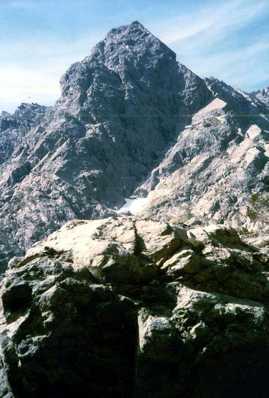
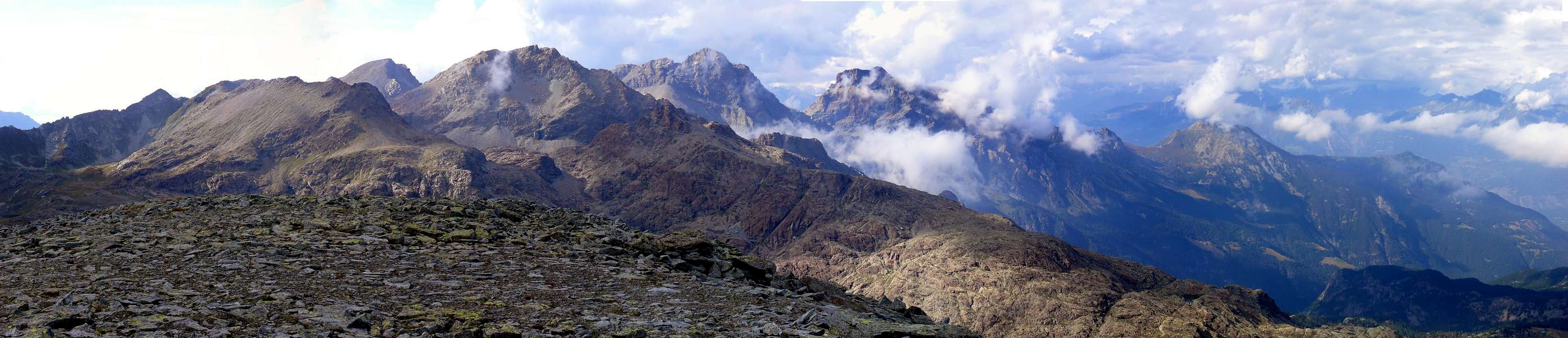
Left: NW Edge, W-SW Face and W-SW Ridge or Normal, by emilius
May 29th, 2005
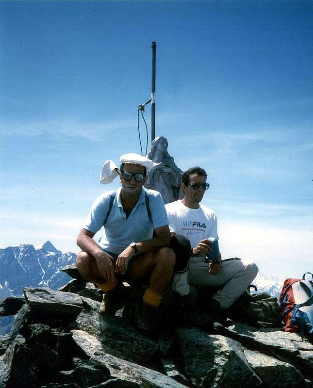
And as the last? When August 27, 2003 with Emilio Bertona and Gianfranco Vicentini we climbed the Col Varotta starting from the tiny village Lusey or Luxe (1.127m) we had been able to appreciate more than the wild Vallone Ponton descending to the valley starting from the Western Slopes of Mont Rouvìc or Revì (2.922m), immediately to the North of Mount Avic. The approach is as long as the prodigal views truly exceptional views in respect of the integrity of the territory, surely one of the most bitter and hard of the entire Valley of Aosta. Reached at a characteristic boulder of rock excavated for use as a storage room and once probably as natural refuge, the Private Shelter of the Forestry Corps, which dominates from the top of the ancient Alp Ponton (2.015m), down there in the walloon. As tiring steep ramp and a long diagonal from left to the right, below the Southwestern Wall of the South Antesummit of Mont Rouvìc, leading to the hill. A long climb and tiring that can be mitigated with a stop near the field of boulders scattered around the refuge. But to find water must, before to begin a climbing on the steep hairpin bends of the ramp, after rising slightly towards the right in a tiny valley head towards South-southeast against the rocks of a dark edge facing Northwest coming down from the mountain Avìc. By the same leak, shimmering above large and blackish rocky plates, many rivulets of water gathering form small waterfalls that go to die on the stony ground below. A quick and easy crossing leads rapidly towards the water, which is already just before reaching them; should go get her to fight the dryness caused by sun glare on these rocks and ribs burned and cooked, which mixed with reddish slabs broken that goes down by Southern Antetop of Mont Rouvìc. This experience is useful when two years later I decided to climb Mount Avic for his unknown West-southwest Face, which descends directly to the head of the Valley of the Ponton. You could, achieved this and continuing for a short time to achieve the same and from there begin to rise, but I prefer to stay on the road for Colle Varotta and then cross to the South through the base of the edge above the altitude of 2.360/70 meters about on the scree. The latter leads to the Face West-southwest before going without great difficulty, except the final triangle of around 120/30 meters formed by rocks steeper but still very broken; returning to the left towards the same, just before reaching the West-southwest Ridge or Normal Route from Lake Gelato. A rocky rift crack into the rocks and just in the middle of these leads me finally to the Top, with rocks more challenging. I go down by the Edge Northwest which, though very short, is really more difficult; This route leads me to the bivouac of the Rangers (2.168m) and from this to the previous path followed during the ascent. At the crossroads at the Torrente Ponton reach La Chervaz (1.205m) and then at the junction nearby Arbussayes Pasture (940m), where this time, as an alternative to Lusey, I started using the path n°1. A tiresome and very labored trek with over 2.000 vertical meters.
Probably for me the last trip around the Avìc, but you can never say ...
![]()
29 Maggio, 2005
Probabilmente per me l'ulimo viaggio intorno all'Avìc, ma non si può mai dir ...
![]()
"Probably for the last time ..." by emilius
Al Plateau delle Rayes e da questo in traversata al colle, sotto l'Iverta. Doppiato a sinistra l'omonimo lago, arrivare sulla Sommità era un gioco da ragazzi: davanti s'aprivano, maestoso, le due Pareti Settentrionali del Glacier che, come detto, conoscevo. Ma per arrivar sin laggiù? Uhmmm, la storia non mi piaceva troppo, perché sembrava di dover attraversare il Sahara con una serie di gobbe che ricordavano le dune d'un deserto. Uhhmbahhh, speriam bene! Scendiam dall'Iverta (2.939 m) facilmente per il Versante Meridionale e, passando sopra ad un minuscolo laghetto, raggiungiamo la Punta di Medzove (2.847 m), che allora non aveva ancor nome e noi chiamammo Punta della Betassa; perché una piccola sella 2.800 metri circa, al termine della Cresta Ovest del Mont Belplà o Bel-Plat (2.828/9 m; Bello Piatto), conduce ad un altipiano detto della Betassa dove, dopo un altro laghetto, inizia a scendere un sentierino (dalla sella ora esiste una traccia, ma a quei tempi era un ripido pendio d'erba "ollina" tra fasce rocciose). Saliam anche quello (puoi pensare se "Crevassino" non lo collezionava!) andando per la facile ma frastaglia cresta in andata e ritorno dalla sella. Scartando a destra i Laghi della Leità ed il Col Mezove (2.614 m), sotto al Glacier, s'arriva al Gran Lago (2.495 m; non esisteva ancora il Rifugio Letey del Corpo Forestale). Ma mentre noi eravamo attratti da quell'incanto, un Diavoletto ci lavorava silenziosamente dietro le spalle: il tempo, caricando l'evaporazione dei laghi, si stava incupendo e preannunciava un temporale imminente. Giù di corsa all'Alpe del Pisonet, ai Laghi Cornuto, Nero e Bianco, dove adesso esiste il Rifugio Barbustel. Ma allora quest'era il posto più selvaggio ed isolato del mondo. Ed adesso?"Crevassino" dice "Si và a Nord!" Bella scoperta, se vogliam tornar casa ... Intanto sopra il cielo rumoreggia e scure nuvole si abbassano sempre di più facendoci aumentare l'andatura. Presto sarà buio e non abbiam neppur una pila. Il cielo tramonta prima sopra l'Avìc e poi in basso verso l'Iverta, L'Invers del Lago Gelato e non si vede più il punto di riferimento del Bec l'Espic, laggiù sopra il Lago della Serva, ove noi dobbiamo arrivar. Una gara persa sin dall'inizio, che diventa una guerra quando i fulmini incominciano a saettare sopra le nostre teste, mandandoci in confusione totale così che, arrivando all'incrocio con l'Alpe Cousse (2.051 m) e vedendo il piccolo sentiero che risale all'Alpe Bayet (2.071 m), invece di seguirlo scendiamo sulla destra. Lo dice la logica, perché noi dobbiamo scendere e non salir. Daltronde non ci son segnalazioni e se esistono al buio noi non le vediamo; ed anche la Mappa nello zaino rimane inoperosa, col buio totale e senza pila. Invece compiam un grande sbaglio: finiamo in una zona di grandi e levigati blocchi alternati a ripide banconate rocciose sulle quali sentiam scorrere dei rivoletti d'acqua in mezzo ad alte frasche e fitti rododendri. Meno male che le vipere saran di già andate a dormire, od almeno lo speriamo. Con una traversata istintiva ed infinita a sinistra, scavalcando un ripido costolone, raggiungiamo la "retta via" ed in breve siamo al lago. Da qui a Voella tutto é più facile, pur inciampando di tanto in tanto. Quando giungiam casa ormai é molto tardi e mia moglie é in trepida attesa "Ma dove porti il bambino con stà cappa nera?". "Crevassino", malefico, non le dà scampo e questo nomignolo di "Cappa Nera" se lo porterà dietro per almeno un ventennio. Così imparano a mischiarsi in "affar d'uomini". Questo é stato il primo Monte Avìc e così me lo ricordo ...
And as the last? When August 27, 2003 with Emilio Bertona and Gianfranco Vicentini we climbed the Col Varotta starting from the tiny village Lusey or Luxe (1.127m) we had been able to appreciate more than the wild Vallone Ponton descending to the valley starting from the Western Slopes of Mont Rouvìc or Revì (2.922m), immediately to the North of Mount Avic. The approach is as long as the prodigal views truly exceptional views in respect of the integrity of the territory, surely one of the most bitter and hard of the entire Valley of Aosta. Reached at a characteristic boulder of rock excavated for use as a storage room and once probably as natural refuge, the Private Shelter of the Forestry Corps, which dominates from the top of the ancient Alp Ponton (2.015m), down there in the walloon. As tiring steep ramp and a long diagonal from left to the right, below the Southwestern Wall of the South Antesummit of Mont Rouvìc, leading to the hill. A long climb and tiring that can be mitigated with a stop near the field of boulders scattered around the refuge. But to find water must, before to begin a climbing on the steep hairpin bends of the ramp, after rising slightly towards the right in a tiny valley head towards South-southeast against the rocks of a dark edge facing Northwest coming down from the mountain Avìc. By the same leak, shimmering above large and blackish rocky plates, many rivulets of water gathering form small waterfalls that go to die on the stony ground below. A quick and easy crossing leads rapidly towards the water, which is already just before reaching them; should go get her to fight the dryness caused by sun glare on these rocks and ribs burned and cooked, which mixed with reddish slabs broken that goes down by Southern Antetop of Mont Rouvìc. This experience is useful when two years later I decided to climb Mount Avic for his unknown West-southwest Face, which descends directly to the head of the Valley of the Ponton. You could, achieved this and continuing for a short time to achieve the same and from there begin to rise, but I prefer to stay on the road for Colle Varotta and then cross to the South through the base of the edge above the altitude of 2.360/70 meters about on the scree. The latter leads to the Face West-southwest before going without great difficulty, except the final triangle of around 120/30 meters formed by rocks steeper but still very broken; returning to the left towards the same, just before reaching the West-southwest Ridge or Normal Route from Lake Gelato. A rocky rift crack into the rocks and just in the middle of these leads me finally to the Top, with rocks more challenging. I go down by the Edge Northwest which, though very short, is really more difficult; This route leads me to the bivouac of the Rangers (2.168m) and from this to the previous path followed during the ascent. At the crossroads at the Torrente Ponton reach La Chervaz (1.205m) and then at the junction nearby Arbussayes Pasture (940m), where this time, as an alternative to Lusey, I started using the path n°1. A tiresome and very labored trek with over 2.000 vertical meters.
Probably for me the last trip around the Avìc, but you can never say ...
E qual l'ultima?
quando il 27 di Agosto 2003 con Emilio Bertona e Gianfranco Vicentini eravamo saliti al Colle Varotta partendo dal minuscolo Villaggio di Lusey o Luxe (1.127 m) avevamo potuto apprezzare il più che selvaggio Vallone del Ponton discendente a valle partendo dalle pendici Occidentali del Mont Rouvìc o Revì (2.922 m), subito a Settentrione del Monte Avìc. L'avvicinamento é tanto lungo quanto prodigo di vedute veramente eccezionali nei confronti dell'integrità del territorio, sicuramente uno dei più aspri dell'intera Valle di Aosta. Raggiunto presso un caratteristico macigno di roccia, scavato per essere utilizzato come ripostiglio ed una volta probabilmente quale rifugio naturale, il Rifugio privato del Corpo Forestale, dominante dall'alto l'antica Alpe di Ponton (2.015 m), laggiù nel fondovalle. Un'erta quanto faticosa rampa ed un lungo diagonale dalla sinistra alla destra, sottostante la Parete Sudovest della Sommità Meridionale del Mont Rouvìc, conducono al colle. Una salita lunga e faticosa, che può essere mitigata con una sosta nei pressi di quel campo di massi sparsi circostanti al rifugio. Ma per trovar dell'acqua bisogna, prima di iniare la salita sui ripidi tornanti della rampa, dopo essere saliti un poco spostandosi verso destra in un minuscolo valloncello, é necessario dirigersi verso Sud-sudest contro le scure rocce d'uno Spigolo rivolto a Nordovest che scende dal Monte Avìc. Dallo stesso colano, luccicando al di sopra di grandi placche rocciose e nerastre, molti rivoletti d'acqua che riunendosi formano delle cascatelle che vanno a morire sulla pietraia sottostante. Una breve e facile traversata porta rapidamente all'acqua, che si trova già prima di raggiungerle; conviene andare a prenderla onde poter combattere l'arsura provocata dal riverbero del sole sopra queste rocce bruciate e cotte, che con lastroni rossicci misti a costoloni in frantumi scendono dall'Antecima Sud del Mont Rouvìc. Questa esperienza mi é utile quando due anni appresso decido di salire il Monte Avìc per la sua sconosciuta Faccia Ovest-sudovest, che scende direttamente verso la testata del Vallone del Ponton. Si potrebbe, raggiunta questa e continuando per breve tempo raggiungere questa e da qui iniziare a salire, ma preferisco restare sulla via per il Colle Varotta e quindi attraversare verso Sud passando alla base dello spigolo di cui sopra alla quota di 2.360/70 metri circa nella pietraia. Quest'ultima conduce verso il Versante Ovest-sudovest, che salgo senza grandi difficoltà tramite un'angusto canalino di detriti da sinistra verso destra, tranne il triangolo finale di 120/30 metri circa formato da rocce più ripide ma sempre molto rotte. Rientrato a sinistra verso il medesimo appena prima di raggiungere la Cresta Ovest-sudovest o Via Normale dal Lago Gelato, una spaccatura-canalino roccioso in mezzo a queste mi conduce nella più ripida parte terminale alla Sommità, che si sale tramite rocce abbastanza rotte ma sicuramente più impegnative. Scendo per lo Spigolo Nordovest che, seppur molto breve, m'impegna maggiormente che non la parete salita; quest'itinerario mi conduce al Bivacco della Forestale (2.168 m) e da questo alla precedente via seguita durante la salita. Raggiunto il bivio presso il Torrente Ponton raggiungo La Chervaz (1.205 m) e successivamente il bivio presso Arbussayes (940 m), ove questa volta, in alternativa al Villaggetto di Lusey, son partito tramite il sentiero n°1. Una bella sfacchinata con oltre 2.000 metri di dislivello in salita ed altrettanti in discesa.Probabilmente per me l'ulimo viaggio intorno all'Avìc, ma non si può mai dir ...
Where do you want to go without Getting There?
BY CAR:
- From TORINO, MILANO, etc: Motorway A5. Exit at IVREA or Quincinetto (PIEDMONT)
From IVREA Town: in West (Southern side and Western Sides) towards Pont Saint Martin, Donnas, Hône, Bard, Champdepraz, Pontey, Fénis Municipalities.
From Courmayeur Resort: in East to Morgex, La Salle, Saint Pierre, Sarre, Aosta (Norhern side), Saint Chistophe; Quart, Nus, Chambave, Verrayes, Saint Denis, Châtillon, Saint Vincent, Emarese, Arnad, Verrès, Hône, Donnas, Pont Saint Martin (Northern and Northeastern Sides) Municipalities.
Southern Side:
From Hône-Bard (364m, 566m), on State Road n°26, towards Pont Bozet (775m) and from this to Champorcher Valley, Camporcher-Château (1.427m), Petit, Grand Mont Blanc, La Cort Villages, towards Dondena Village (2.092m), Dondena & Miserin Refuges, through Royal Road and dirt roads; Barbustel Refuge, through Royal Road and path towards Champdepraz Vallon.
Northern Side:
From Champdepraz (523m) to Lakes Vallon and Voella or Raye Chevrères Village (1.307m; by Regional Road). Barbustel Refuge with path from Voella.
Western Side:
From Fénis (537m) to Clavalité-Grand'Alpe Pastures (2.129m; through dirt road), just below E. Borroz/Rotary-Clavalité Refuge (2.156m) at Cuneu Alp. - From FRANCE: through the Mont Blanc Tunnel to Entrèves-crossroads to Vény and Ferret Valleys above Courmayeur-Resort. By Little Saint Bernard Pass, closed since November until half May towards La Thuile Valley descending on Pré Saint Didier Commune.It is not necessary to take Motorway A5: you can drive on SS.26, in the direction of AOSTA - IVREA - TURIN.
BY PLANE:
- Aeroporto "Corrado Gex" Saint Christophe (Aosta).
Mountain Conditions
- You can get meteo information at the official site of the Regione Valle d'Aosta:
- Valle d'Aosta Meteo
Important Information
- REGIONE AUTONOMA VALLE D'AOSTA the official site.
- FONDAZIONE MONTAGNA SICURA Villa Cameron, località Villard de la Palud n° 1 Courmayeur (AO) Tel: 39 0165 897602 - Fax: 39 0165 897647.
- A.I.NE.VA. (Associazione Interregionale Neve e Valanghe).
External Links
Useful numbers
- Protezione Civile Valdostana località Aeroporto n° 7/A Saint Christophe (Ao) Tel. 0165-238222.
- Bollettino Meteo (weather info) Tel. 0165-44113.
- Unità Operativa di Soccorso Sanitario Tel. 118.