


-
 2995 Hits
-
 77.48% Score
-
 8 Votes
|
|
Route |
|---|---|
|
|
45.67161°N / 7.02849°E |
|
|
Trad Climbing |
|
|
Summer, Fall |
|
|
A long day |
|
|
A/PD/PD+/AD- |
|
|
II |
|
|
Note
|
La montagna chiama i suoi figli, ed essi rispondono fedelmente al suo appello… Osvaldo Cardellina, Diario alpinistico, 1964-65 Page texts: @ OsvaldoCardellina "Osva", passed away on May 2, 2022. Page owners: Christian Cardellina e Osvaldo Cardellina. Any updates from September 12, 2022: Antonio Giani, page administrator, friend and climbing companion. Testi della pagina: @ OsvaldoCardellina "Osva", scomparso il 2 maggio 2022. Proprietari pagina: Christian Cardellina e Osvaldo Cardellina. Eventuali aggiornamenti dal 12 settembre 2022: Antonio Giani, amministratore della pagina, amico e compagno di salite. |
Clothespins Overview
This magic "Cima" or Summit is marginalized and out of touch. In fact it belongs to the Testa (Head) of the Rutor or Ruitor Group, but almost no one knows.
This pyramid, mostly rocky, is formed by three main ridges, while an sinous edge just accentuated and less obvious winding down towards the North by separating the icy North Face from Northwest, only rock and suspended over the Glacier de la Tete de Paramont. At the Southern edge of this falls in the direction of the Valley of La Thuile the West Ridge-northwest or Normal Route that reaches the Col des Ussellettes (2.989m), while to the South-southwest and over the Glacier des Ussellettes detaches the watershed between the valley with Valgrisenche that bypassed over the Petit Paramont comes to carving 3.160 meters and then continue to Becca Bianca (White), Nera (Black) and Pointe Chenal up the important Planaval Pass (3.016m), beyond which outlines the true and reallly Group of the Rutor or Ruitor. On the other side the partition between the two proceed to the Northeast and, after the altitudes 3.187, 3.184 meters, outperforms over the rock headland of Mont Pit (2.914m) and then sloping towards Col de Paramont but better known as the Mollette's Pass (Tongs; 2.744m) between the Vallon of Fond (East) and Vallon d'en Haut above Lazey Pasture (1.503m) and Villair between La Salle Derby.
Through this Northeast Ridge and along the first of the two valleys takes place this climb, not very difficult but quite long, which provides a not simple return to Valgrisenche. Otherwise there, after proper logistic organization, the possibility of an easier descent to the Refuge Albert Deffeyes (2.500m) in the adjacent Valley of La Thuile.
![]()
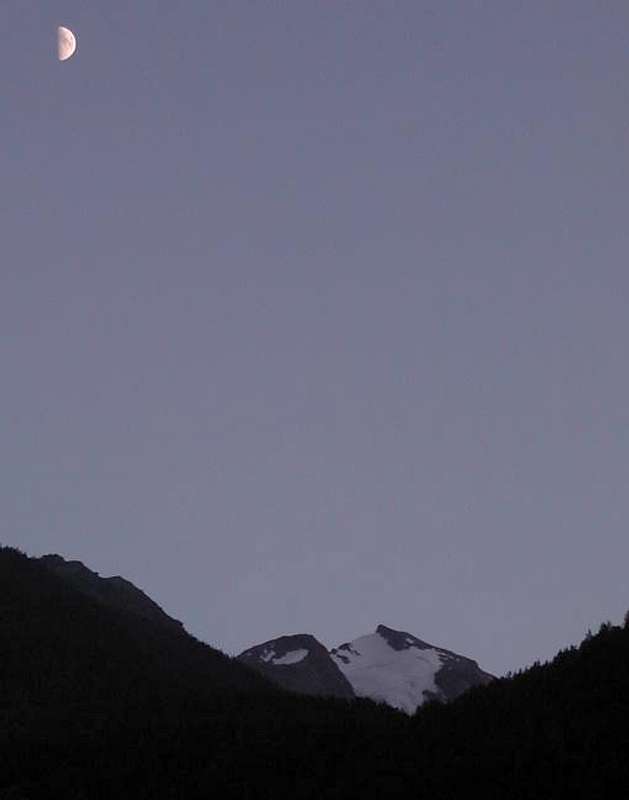
Mont Pit (2.914m) & Mont Paramont (3.301m) from Northwest, by Zed 2005
This pyramid, mostly rocky, is formed by three main ridges, while an sinous edge just accentuated and less obvious winding down towards the North by separating the icy North Face from Northwest, only rock and suspended over the Glacier de la Tete de Paramont. At the Southern edge of this falls in the direction of the Valley of La Thuile the West Ridge-northwest or Normal Route that reaches the Col des Ussellettes (2.989m), while to the South-southwest and over the Glacier des Ussellettes detaches the watershed between the valley with Valgrisenche that bypassed over the Petit Paramont comes to carving 3.160 meters and then continue to Becca Bianca (White), Nera (Black) and Pointe Chenal up the important Planaval Pass (3.016m), beyond which outlines the true and reallly Group of the Rutor or Ruitor. On the other side the partition between the two proceed to the Northeast and, after the altitudes 3.187, 3.184 meters, outperforms over the rock headland of Mont Pit (2.914m) and then sloping towards Col de Paramont but better known as the Mollette's Pass (Tongs; 2.744m) between the Vallon of Fond (East) and Vallon d'en Haut above Lazey Pasture (1.503m) and Villair between La Salle Derby.
Through this Northeast Ridge and along the first of the two valleys takes place this climb, not very difficult but quite long, which provides a not simple return to Valgrisenche. Otherwise there, after proper logistic organization, the possibility of an easier descent to the Refuge Albert Deffeyes (2.500m) in the adjacent Valley of La Thuile.

Mont Pit (2.914m) & Mont Paramont (3.301m) from Northwest, by Zed 2005
Questa Cima risulta emarginata e pressocché fuori dal mondo. Infatti appartiene al Gruppo della Testa del Rutor o Ruitor, ma par che quasi nessun lo sappia.
Questa piramide, prevalentemente rocciosa, é formata da tre creste principali, mentre uno spigolo poco eccentuato ed evidente scende sinuoso verso Settentrione separando la ghiacciata Parete Nord da quella Nordovest esclusivamente rocciosa e sospesa sopra il Glacier de la Tete de Paramont. Al margine Meridionale di questa scende in direzione della Valle di La Thuile la Cresta Ovest-nordovest o Via Normale che raggiunge il Col des Ussellettes (2.989 m), mentre verso Sud-sudovest e sopra il Glacier des Ussellettes si distacca lo spartiacque tra questa valle con la Valgrisenche che, scavalcato il Petit Paramont arriva allo intaglio 3.160 metri per poi continuare verso Becca Bianca, Nera e Pointe Chenal fino allo importante Passo di Planaval (3.016 m), oltre il quale si delinea il vero e proprio Gruppo del Rutor o Ruitor. Sul fronte opposto il divisorio tra le due vallate procede verso Nordest e, dopo le due piccole quote 3.187 e 3.184 metri, scavalca la testa rocciosa del Mont Pit (2.914 m) per poi digradare verso il Col de Paramont ma più conosciuto come Colle delle Mollette (2.744 m) tra il Vallone del Fond (Oriente) ed il Vallon d'en Haut al di sopra dell'Alpeggio di Lazey (1.503 m) e del Villair tra La Salle e Derby.
Tramite questa Cresta Nordest e lungo il primo dei due valloni si svolge questa salita, non molto difficile ma alquanto lunga e che prevede un rientro non semplice in Valgrisenche. Altrimenti sussiste, previa adeguata organizzazione logistica, la possibilità di una più facile discesa in direzione del Rifugio Albert Deffeyes (2.500 m) nell'attigua La Thuile.
![]()
![]()
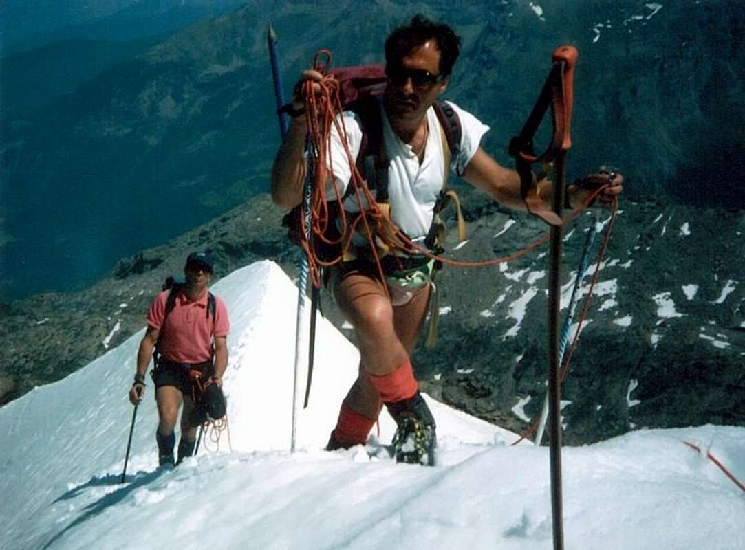
Just below the Summit, by Osw 1996
Questa piramide, prevalentemente rocciosa, é formata da tre creste principali, mentre uno spigolo poco eccentuato ed evidente scende sinuoso verso Settentrione separando la ghiacciata Parete Nord da quella Nordovest esclusivamente rocciosa e sospesa sopra il Glacier de la Tete de Paramont. Al margine Meridionale di questa scende in direzione della Valle di La Thuile la Cresta Ovest-nordovest o Via Normale che raggiunge il Col des Ussellettes (2.989 m), mentre verso Sud-sudovest e sopra il Glacier des Ussellettes si distacca lo spartiacque tra questa valle con la Valgrisenche che, scavalcato il Petit Paramont arriva allo intaglio 3.160 metri per poi continuare verso Becca Bianca, Nera e Pointe Chenal fino allo importante Passo di Planaval (3.016 m), oltre il quale si delinea il vero e proprio Gruppo del Rutor o Ruitor. Sul fronte opposto il divisorio tra le due vallate procede verso Nordest e, dopo le due piccole quote 3.187 e 3.184 metri, scavalca la testa rocciosa del Mont Pit (2.914 m) per poi digradare verso il Col de Paramont ma più conosciuto come Colle delle Mollette (2.744 m) tra il Vallone del Fond (Oriente) ed il Vallon d'en Haut al di sopra dell'Alpeggio di Lazey (1.503 m) e del Villair tra La Salle e Derby.
Tramite questa Cresta Nordest e lungo il primo dei due valloni si svolge questa salita, non molto difficile ma alquanto lunga e che prevede un rientro non semplice in Valgrisenche. Altrimenti sussiste, previa adeguata organizzazione logistica, la possibilità di una più facile discesa in direzione del Rifugio Albert Deffeyes (2.500 m) nell'attigua La Thuile.

First Ascents
- First on the Northeast Ridge: Emanuele Andreis, Luigi Bon and Enrico Denina; August 03th, 1927 .
- In winter: Unknown.
Getting There
BY CAR:
![]()
"This is the Road Master ... by Liverogne to Planaval ... / Questa é la Strada Maestra ... da Liverogne a Planaval ..." ![]()
BY PLANE:
- From TORINO, MILANO, etc: Motorway A5. Exit at AOSTA West (Aymaville) or Morgex Municipalities.
- From IVREA Town to Villeneuve, Arvier, Pré Saint Didier Municipalities.

- From Liverogne (Arvier) to Planaval in Valgrisenche
From Arvier to Liverogne Fraction (730m) and from this to Valgrisenche Valley, up to the Planaval Hamlet (1.577m) and La Clousaz, Baulin or Baulen Villages (1.631m, 1.758m). - From FRANCE: through the Mont Blanc Tunnel to Entrèves-crossroads to Vény/Ferret Valleys - Mountain Guides of Courmayeur - La Saxe Rock Gym - Courmayeur. By Little Saint Bernard Pass, closed since November until half May to La Thuile Valley - Pré Saint Didier - Courmayeur.
It is not necessary to take Motorway A5: you can drive on SS.26, in the direction of AOSTA - IVREA - TURIN.
BY PLANE:
- Aeroporto "Corrado Gex" Saint Christophe (Aosta)
Approach & Route Description
 |
 |
 |
 |
 |
At the first bend in the shape of elbow immediately after the small Village of La Clusaz started with the path n° 21/Alta Via n° 2 (numerous yellow signs), leaving on the right the Municipal Road continues towards the small Village of Baulen or Baulin (1.769m). Instead proceeding with West-northwest direction with a long diagonal, followed by a series of narrow and small hairpin bends, get near the Torrent of Planaval at an altitude of about 2.150 meters. Walk along its shore hydrographic left (North), leaving on the left the Glacier Pasture (2.162m) and on the right path n° 20B which goes to the Torre Tonda Hill (to the North). Continue in parallel with the torrent and then move away temporarily from the same, when it meets to Torrent de l'Orfeuille. Immediately after crossing it twice before returning to skirt the Northern shore with West-northwest direction first and then definitely in the Southwest towards the old Fond Alpage (2.338m) under the Lake of the same name (2.438m). Not achieve both, but, if the path changes direction (F; 1h'30/1h'45), abandon it and climb to the right (North-northwest) along the moraine between Mont de la Crosatie (North) and the Mont Pit (towards the South; 2.914m), reaching through a final stretch more steep, Mollette's Pass (2.744m). From thys turn left and drive along the North-northeastern Ridge of Mont Pit passing in succession a small indented elevations (I°+/II°-/II°+ , on the edge of the ridge) followed by two rounded hillocks. In the final part, rising with less slope and the straight path pseudo first on the rocky edge and then step and snowy, reach, after a turret, the enough wide Summit (A/ from F+ to AD-; 5h'30/6h'00 from La Clusaz).
 |
 |
 |
 |
 |
Al primo tornante a forma di gomito subito successivo al Villaggetto di La Clusaz iniziare con il sentiero n° 21/Alta Via n° 2 (diverse segnalazioni in giallo), lasciando sulla destra la strada che continua verso il Villaggio di Baulen o Baulin (1.769 m). Procedendo invece con direzione Ovest-nordovest con un lungo diagonale, seguito da una serie di stretti e piccoli tornanti, arrivare nei pressi del Torrent di Planaval a quota 2.150 metri circa. Costeggiare la sua sponda idrografica sinistra (Nord), lasciando sulla sinistra l'Alpe di Glacier (2.162 m) e sulla destra il sentiero n° 20B dirigentesi al Colle della Torre Tonda (a Settentrione). Proseguire in parallelo con il torrente per poi allontanarsi momentaneamente dallo stesso, quando questo si riunisce al Torrent de l'Orfeuille. Subito dopo attraversarlo due volte per poi ritornare a fiancheggiare la sponda Settentrionale con direzione prima Ovest-nordovest ed in seguito decisamente a Sudovest verso le Baracche di Fond (2.338 m), al di sotto dell'omonimo Lago (2.438 m). Non raggiungere entrambi, bensì, laddove il sentiero inverte di direzione (F; 1h'30/1h'45), abbandonarlo e risalire verso destra (Nord-nordovest) lungo la morena compresa tra la Punta della Crosatie (Nord) ed il Mont Pit (2.914 m) raggiungendo, tramite un tratto finale più ripido, il Colle delle Mollette (2.744 m). Dal colle volgere a sinistra e percorrere la Cresta Nord-nordest del Mont Pit superando in successione alcune asperità (I°+/II°-/II°+ sul filo) seguito da due dossi arrotondati. Con la parte finale, che sale con minor pendenza e percorso pseudo rettilineo dapprima sul ripido filo roccioso indi nevoso, raggiungerne, dopo una torretta, l'ampia Vetta (A/ da F+ a AD-; 5h'30/6h'00 da La Clusaz).
From F+ to PD/PD+/AD-.
Dal F+ al PD/PD+/AD-.
![]()
Essential Gear
DifficultiesFrom F+ to PD/PD+/AD-.
Dal F+ al PD/PD+/AD-.

Equipment
For Mountaineering, better with rope.
Da Alpinismo, meglio con corda.
For Mountaineering, better with rope.
Da Alpinismo, meglio con corda.
Campings
Remember that free camping is forbidden (except for emergency reasons, over 2.500m, from darkness until dawn).Mountain Condition
- Meteo: you can find all the needed informations at the official site of the Valle d'Aosta Region:
- Valle d'Aosta Meteo
Webcam
- WEBCAM on Aosta Valley:
- Webcam
Books and Maps
BOOKS:- "Guida delle Alpi Occidentali" di Giovanni Bobba e Luigi Vaccarone C.A.I. Sezione di Torino Volume II (parte II) 25-05-1896.
- "Guida della Regione Autonoma Valle d'Aosta" di Mario Aldrovandi, Ed. S.P.E. di Carlo Fanton Torino 1964.
- "80 itinerari di Escursionismo Alpinismo e Sci Alpinismo in Valle d'Aosta", di Osvaldo Cardellina, Ed. Musumeci, Giugno 1977 (in Italian); seconda Ed. Luglio 1981; terza Ed. Luglio 1984; (in French), prima Ed. Febbraio 1978; seconda Ed. Marzo 1980.
- "Guida dei Monti d'Italia Alpi Graie Centrali" di Alessandro Giorgetta - Club Alpino Italiano-Touring Club Italiano, 1985 (in Italian).
- "Ascensioni 1964-1969" Diario Alpinistico di Ilario Antonio Garzotto (unpublished).
- "Diari Alpinistici" di Osvaldo Cardellina e Indice Generale accompagnato da Schedario Relazioni Ascensioni 1964-2019 (unpublished).
 |
 |
 |
 |
 |
 |
MAPS:
- Kompass "Massiccio del Monte Bianco Valle d'Aosta" sentieri e Rifugi Carta turistica 1:50.000.
- Kompass "Gran Paradiso Valle d'Aosta" sentieri e Rifugi Carta turistica 1:50.000.
- L'Escursionista "La Thuile-Piccolo San Bernardo" Carta dei sentieri (n° 2) 1:25.000.
- Enrico Editore Ivrea-Aosta "Gruppo del Gran Paradiso" 1:50.000.
- I.G.M. Istituto Geografico Militare Maps 1:25.000.
Important Information
- REGIONE AUTONOMA VALLE D'AOSTA the official site.
- FONDAZIONE MONTAGNA SICURA Villa Cameron, località Villard de la Palud n° 1 Courmayeur (AO) Tel: 39 0165 897602 - Fax: 39 0165 897647.
- COMPAGNIE DES GUIDES RUTOR Fraz. Entrèves tel/fax 0039.0165.885574 e-mail Guidealpine@lathuile.it
- A.I.NE.VA.(Associazione Interregionale Neve e Valanghe).
 |
 |
 |
 |
 |
Useful Numbers
- Protezione Civile Valdostana località Aeroporto n° 7/A Saint Christophe (Ao) Tel. 0165-238222.
- Bollettino Valanghe Tel. 0165-776300.
- Bollettino Meteo Tel. 0165-44113.
- Unità Operativa di Soccorso Sanitario Tel. 118.