
-
 1376 Hits
-
 81.84% Score
-
 14 Votes
|
|
Mountain/Rock |
|---|---|
|
|
46.02176°N / 10.48222°E |
|
|
Trentino / Lombardia |
|
|
Hiking, Mountaineering, Skiing |
|
|
Spring, Summer |
|
|
9478 ft / 2889 m |
|
|
Overview
Monte Re di Castello 2889 m
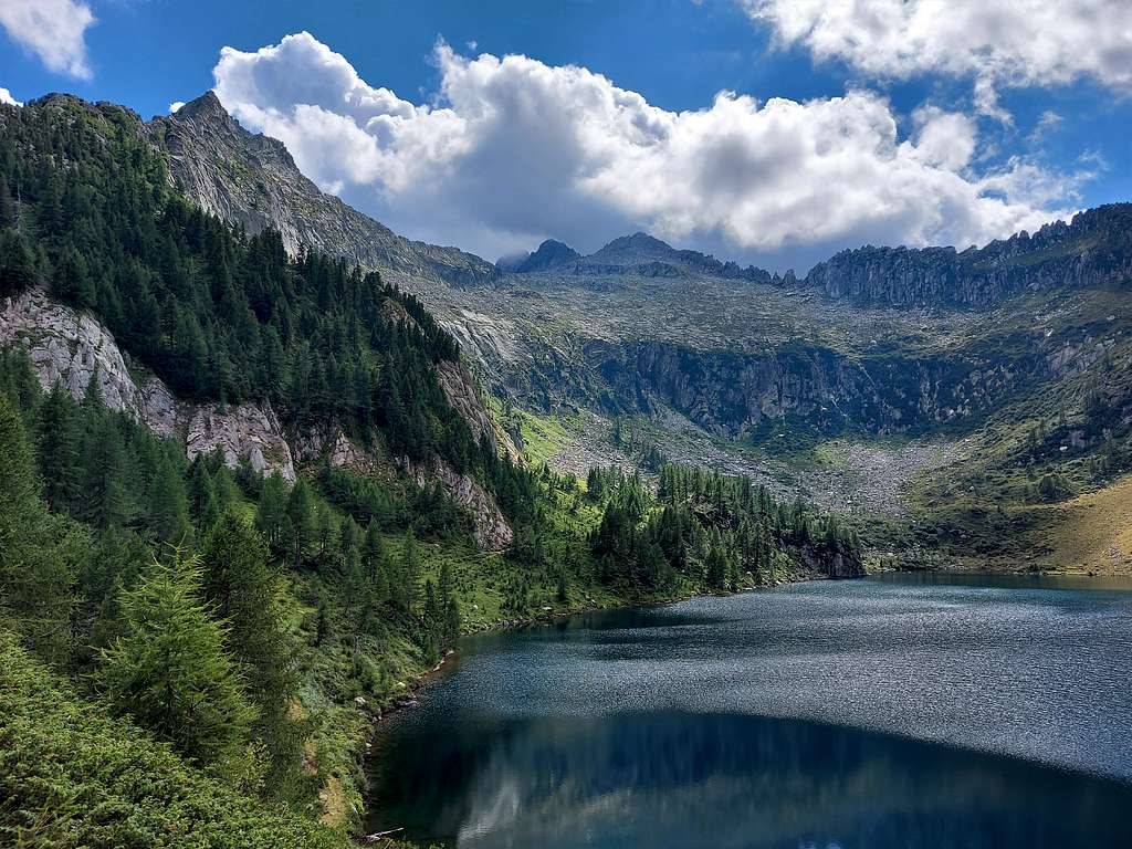
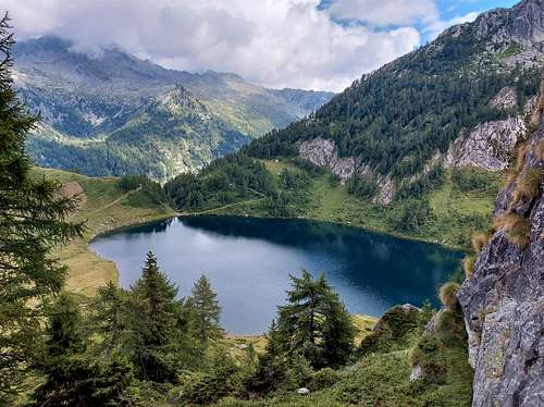
Monte Re di Castello 2889 m is a wild and imposing mountain belonging to the Adamello group and located on the border between the provinces of Trento and Brescia. It is a characteristic mountain located between the Passo della Vedretta di Saviore, which keeps this name even if the vedretta (small glacier) has completely disappeared, and Passo Dernal. The mountain has two ridges converging at right angles, the Western ridge which forms the fore-summit at 2883 m and the Northern ridge. The quickest and shortest climb to Monte Re di Castello takes place starting from the head of the Val Daone. This is the itinerary described on this page, corresponding to the standard route to reach the summit. The ascent route passes near Lago di Campo, a beautiful water mirror in an equally beautiful alpine setting. This ascent at the end of the 90s included the transit on the Vedretta di Saviore in the summit section, unfortunately today completely disappeared due to the climate changes.
This mountainous area was hit by the First World War, as it was crossed at the time by the border between the Kingdom of Italy and the Austro-Hungarian Empire. Numerous WWI remains are also present on the summit of the Re di Castello which during the war was garrisoned by the Italian army.
Getting There
The access to Monte Re di Castello takes place by car driving up the entire Val Daone.
Road access
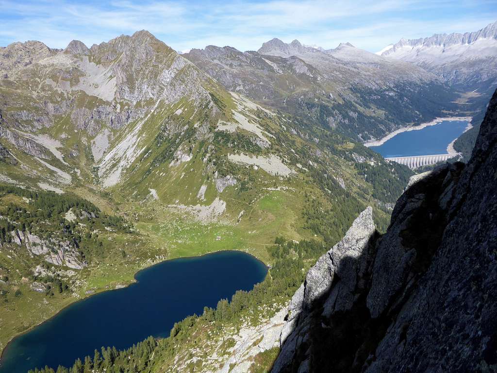
From Tione follow the state road n. 239 del Caffaro in the direction of Pieve di Bono up to Lardaro. After the village turn right to Praso-Daone, entering Val Daone. The asphalted road continues for 17 km, crossing Vermongoi, Limes, Pracul, Boazzo. After passing the artificial lake of Malga Boazzo, you enter Val di Fumo and, following the road, continue to the artificial Lake of Malga Bissina. A very short stretch of road 300 meters long and indicated by signs allows you to go up from the bar at the dam to the large public parking lot above at an altitude of about 1810 m where we can leave the car.
Monte Re di Castello Normal Route
Difficulty: Alpine F
Difference in level: 1090 m. from Malga Bissina parking lot
Exposure: NW
It is the best known and most popular route to reach the summit. At one time it was necessary climb up the small Vedretta di Saviore, which now completely disappeared has left room for a characteristic and infinite slope of large granite boulders.
From the parking lot, proceed following the wide track in an easterly direction for a few tens of meters up to a grassy clearing with signposts, where we take the path n. 242 with signposts to Lago di Campo and Passo di Campo. We immediately will lose altitude between easy grassy steps and then continue halfway up the well-marked path that crosses the slopes of Cima d'Avolo inside a sparse wood. The path continues to rise, reaching a saddle where it appears the large basin that hosts the beautiful Lago di Campo 1944 m, closed to the west by the main ridge with the summit of Re di Castello on the left and Passo di Campo on the right. With a short descent the path reachs the Lago di Campo, passing by the remains of Malga Campo di Sopra 1953 m. The path soon starts to rise again towards the slope in front of us, leaving the Lago di Campo behind us. The forest becomes increasingly sparse, replaced by the high altitude prairie with a beautiful view of the surrounding mountains. The last stretch of the path passes through meadows, then oblique to the right until it easily reaches the evident saddle of Passo di Campo 2288 m on the border between Lombardy and Trentino (signposts).
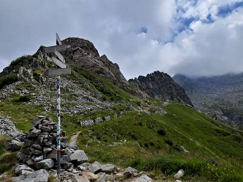
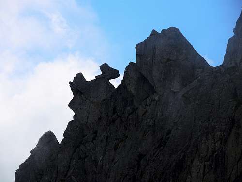
Passo di Campo is an important crossroads of paths. Ignore the path that descends towards the artificial basin of Lago di Arno below and also the branch of the "Adamello Path" (trail n. 1) which turns to the right. Take instead the branch of the "Adamello Path" which continues flat to the left, keeping just to the right of the rocky ridge above, named Sega d'Arno, running between Passo di Campo and Passo della Vedretta di Saviore, in the direction of Re di Castello. Numerous artificial tunnels and trenches of the WWI can be seen on the rocks overlooking the path. The path reaches a short rocky strip, at which it loses slightly altitude (short metal chain). The path proceeds slightly uphill towards a chaotic mass of rocks and debris. In front of us we notice the wide rocky slope that was occupied by the Vedretta di Saviore and on which our ascent route will be articulated. A little further on we are in fact at an important crossroads: we leave the trail marker n° 1 which proceeds crossing to the right towards the Maria e Franco Refuge at the Dernal Pass to follow the signs on the rocks to the top of the Re di Castello. The route climbs, as anticipated, on the wide and immense detrital slope: for a hundred meters we are facilitated in the progression by the presence of a well-constructed military path that is lost almost immediately in the debris.
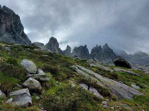
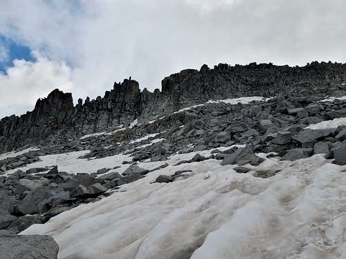
The continuation takes place without technical difficulty but hardly along the chaotic terrain of large boulders, where the right direction is indicated by rare signs and by some cairns. You gain altitude on a steep and uncomfortable surface, where the ascent route always remains parallel at a certain distance from the wild ridge on the left known as Sega d’Arno, formed by a long sequence of steep and pointed rocky peaks. The exposure to the NW means that along the steep slope of large granite boulders some snow fields persist until late summer. About a hundred meters below the vertical of the highest point of the ridge, the route joins the one coming from the right from the Maria e Franco Refuge at the Dernal Pass.
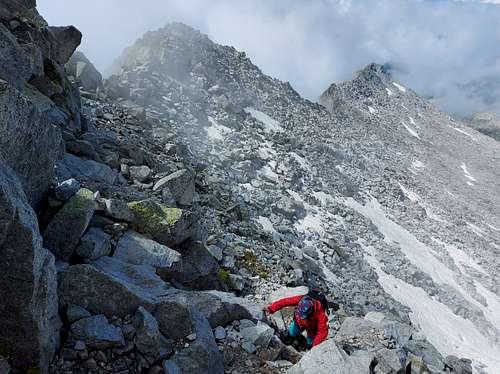
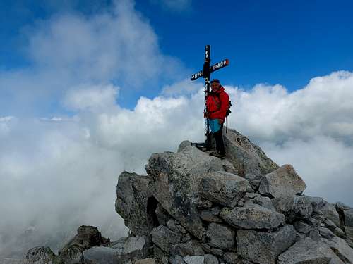
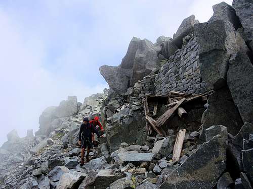
The last steep stretch is common to both routes and here we face the most tiring part of the climb, with some easy climbing steps between gigantic granite boulders. The itinerary crosses the ruins of a WWI semi-destroyed building located just below the highest point, from where you quickly climb to the summit (cross and peak book, vast panorama).
Descent: reversing the route
Red Tape
 |
 |
The access to the parking lot near the dam of Malga Bissina is regulated during the summer period and is subject to the reservation of the parking space on the specific website and the payment of a ticket (6 euros summer 2021). See Malga Bissina parking lot. A No fees no permits needed and no particular restriction in climbing and hiking. The Adamello Group is situated within Parco Naturale Adamello-Brenta, the largest protected area in Trentino, established in 1967. It's located in Western Trentino and with its 620.51 square kilometers includes the mountain groups of Adamello, Presanella and Brenta Dolomites, separated by Val Rendena. On the Lombardia side there is the Parco dell'Adamello, extending for 510 square kilometers on the left orographic side of Valle Camonica, in the north-eastern portion of the Province of Brescia. Camping is not allowed and fires are strictly forbidden.
When to Climb
Mountaineering: from July to September
Ski-mountaineering: from March to May
Where to stay
The nearest hut is Rifugio Maria e Franco al Passo Dernal 2574 m.
Different possibilities of accomodation in Val Daone.
Meteo
Meteo Trentino
Meteo ARPA Lombardia
Guidebooks and maps
-Guidebooks
"Adamello" Vol. I - Pericle Sacchi - Collana Guide dei Monti d'Italia CAI-TCI
 |
-Maps
"Adamello - Presanella" - Tabacco scala 1:25000
"Adamello, Val di Fumo, Val di Genova" - Kompass n. 638
"Adamello - Presanella" - 4LAND Alpine Cartography n. 138 1:25.000