
|
|
Mountain/Rock |
|---|---|
|
|
20.92052°N / 95.25417°E |
|
|
Hiking |
|
|
4980 ft / 1518 m |
|
|
Overview
Mount Popa is a stratovolcano in central Myanmar, and is the northernmost major summit in the Pegu Range. The mountain is southeast of the popular tourist destination Bagan, and is located within and protected by Mt. Popa National Park. The name Popa is believed to derive from the Sanskrit word puppa, meaning flower. The northern section of Mt. Popa’s crater rim has collapsed, leaving a deep, mile-wide caldera, with just over half of the crater rim intact. As with many volcanoes, volcanic ash has contributed to rich soil, and the base of the volcano is covered in lush vegetation, thinning to grass on the outer slopes as one reaches the upper mountain.
Mount Popa is a popular destination for local people, and there is much history and many legends involving the mountain. For more information, check out the Wikipedia page here.
Mount Popa the volcanic plug or Mount Popa the volcano?
Most locals refer to a steep volcanic plug on the southwest side of the volcano as Mt. Popa, rather than the volcano itself. The volcanic plug (actually called Taung Kalat) has a Buddhist monastery on its top, and is quite impressive. When arranging transportation to hike Mt. Popa proper, you may have a difficult time explaining that you do not want to go to the monastery. You will need to find someone that understands that you want to head to the Mt. Popa Mountain Resort so that you can hike the volcano.

Getting There
The hike starts from the Mt. Popa Mountain Resort, at an elevation of about 800 meters (2600 feet). As foreigners aren’t allowed to rent motorbikes and car rentals are unavailable, the most practical way to get there is by taxi and it takes about one hour from Bagan. I negotiated a roundtrip ride where the driver would wait for me for 40000 kyats (~$39 USD). Once at the resort, head to the reception area to get a crude paper map, then head to the overlook to get a view of the monastery on top of Taung Kalat.
Don’t Believe the Hype
While trying to arrange my ride, I was told things from “foreigners aren’t allowed”, or I’d need a guide, or that the hike will take two days. I was told by my driver that he had driven many foreigners to the monastery, but I was the first that he’d met who wanted to hike to the summit (certainly I’m far from the first foreigner to hike to the summit though). I wondered if I was wasting my time and money on the ride, but all went smoothly, and the hike took me just over 3 hours roundtrip at a brisk pace with a few stops for photos.
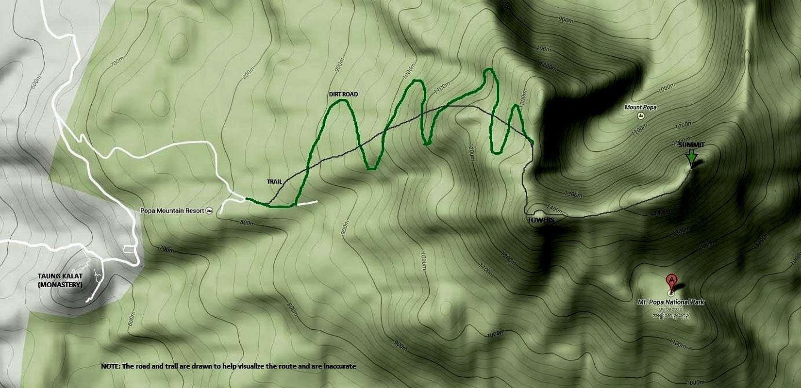
Route
From the Mt. Popa Mountain Resort, walk back down the paved road you drove in on. Follow the road just a few minutes, crossing over a small white bridge, then take an immediate right onto an obvious dirt road that has been cut through thick brush. After ten or so minutes of hiking on the rough dirt road, you’ll run into another road, intersecting sharply from the left. Take this left, and follow this road as it switchbacks all the way up to the crater rim, gaining about 550 meters (1800 feet). From the crater rim, you should see the true summit to the southeast, topped by a golden pagoda.
Turn your attention to the false summit to the south, topped by several structures and antennas, and head this direction, finding an obvious trail that leads to cement stairs and eventually up to the towers. Skirt around the left side of the towers towards the true summit. You’ll drop slightly at a saddle before working your way up to the first golden pagoda. From that pagoda, continue on to a second and slightly higher golden pagoda on the true summit. The views from here are outstanding.
Total elevation gain is approximately 700 meters (2300 feet).
I’m guessing the distance is about 5.5km (3.5 miles) one way.
Alternate Route
There is a trail that intersects the switchbacking road, perhaps 8 or more times (I didn’t count but remember it was quite a few). The trail is steeper and direct, and you can switch between the trail and road as desired. The trail and road converge at the crater rim. See the map here for clarity.

Red Tape
By the time you reach Mount Popa, you are most likely aware that it is expected to be barefoot when walking around religious structures in Myanmar. The same should be exercised if you walk on the tiled surfaces of the pagodas on Mount Popa.