
-
 6955 Hits
-
 70.83% Score
-
 1 Votes
|
|
Mountain/Rock |
|---|---|
|
|
38.99379°N / 112.19593°W |
|
|
Sevier |
|
|
Hiking |
|
|
Spring, Summer, Fall, Winter |
|
|
10022 ft / 3055 m |
|
|
Overview
Mount Catherine is one of a cluster of 10,000-foot peaks in the northern part of the Pahvant Mountain Range in Central Utah. From the west, it rises almost 5,000 feet above the town of Fillmore, Utah on the edge of the basin and range country.Getting There
Take highway 50 that runs between Scipio and Sevier Valley (towns of Salina, Aurora, Redmond). Approximately 5 miles out of the Sevier Valley, then turn west and drive along Forest Road 102. It meanders up a canyon and gains the main backbone of the range after several miles. Most passenger vehicles can make it up this road. The road that travels north-south in the range is Forest Road 96. Turn right (north) onto this road. The first peak encountered is Willow Creek Peak, but the second is the taller Jacks Peak.From the western slope of Jack’s Peak, drive straight west to the Pioneer Peak as far as you can (<1 mile).Route
From the end of the dirt road, a faint path can be made out in the alpine foliage. Follow this up to the south (left) shoulder of Pioneer Peak. It travels south from the shoulder for a long way before it turns west and follows the ridge between Pioneer Peak and Mount Catherine. Watch out for all the cow dung. Once in the saddle, follow the faint trail up the eastern slope of Mount Catherine that tends to stay more on the south side of the ridge.Round-trip Distance: 5 miles
Elevation Gain: 400 feet (absolute), 800 feet (total)
![Topo to Mt Catherine]()
Topo to Mt Catherine
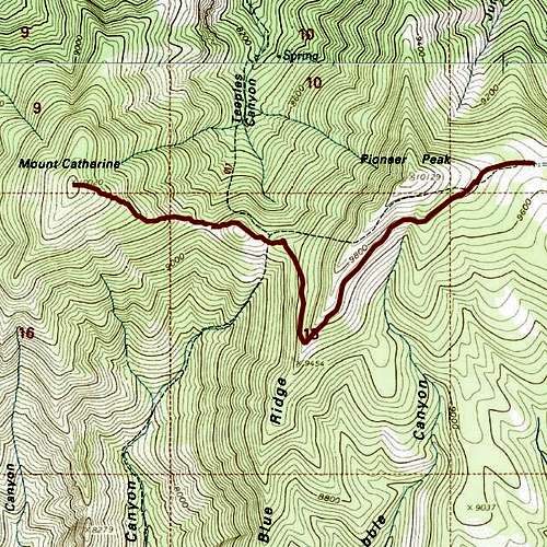
Topo to Mt Catherine