
-
 3443 Hits
-
 80.49% Score
-
 12 Votes
|
|
Mountain/Rock |
|---|---|
|
|
46.36035°N / 11.19224°E |
|
|
Hiking, Scrambling, Via Ferrata, Skiing |
|
|
Spring, Summer, Fall, Winter |
|
|
6942 ft / 2116 m |
|
|
Overview
The summit of Monte Roen
___
* By some classifications it's even the highest in the group, but into the Nonsberg group we should put also the small group of Monte Luco / Laugenspitze, which is higher than Monte Roen.
The Roen Massif
Across the main ridge one good road goes, connecting the Adige valley (Bolzano) with the Val di Non. That's the picturesque road over the Passo di Mendola / Mendelpass, 1363 m.
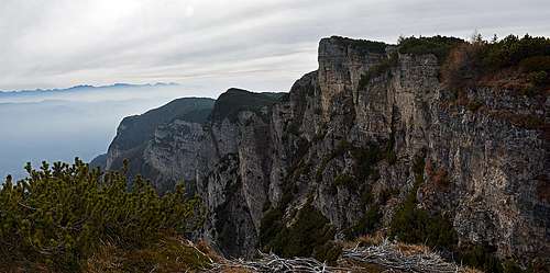
The same is the situation in the narrow area of Monte Roen. The map reveals wild eastern walls and steep gorges, which also all the eastern routes avoid, either by the northern, or the southern side. The summits in the main ridge, other than the Roen itself, are not much important. They have their names, many of them can be easily crossed by marked paths, or reached in short ascents by deterring from the paths, but a real hiking objective is actually only the highest point.
The summit part of Monte Roen is built of triassic dolomites of various ages and characteristics. Older (paleozoic) rocks can be found only in lower parts on the eastern side.
San Romedio Sanctuary

San Romedio

The access path

The shrine
The sanctuary is built on an impossibly steep, rocky side spur, deep in the canyon of Romedio creek. The road reaches till below the rock, but it's more nice to walk there from the Sanzeno in the main valley. Park above the village, at Museo Retico, where the amusing gallery path starts. The ancient aquaduct was converted into an exposed, but completely secured path, suitable also for children. After some 45 minutes you reach below the sanctuary and then you need to ascend steeply up to it. After visiting it, it's very worth going another 5 minutes up, to a small cemetery, from which you have a great view down on the monastery.
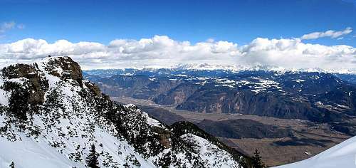
Summit views

Northern views

Southern views
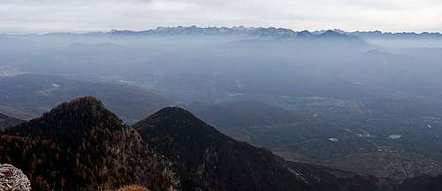 Dolomites across the Adige/Etsch valley |
Getting There
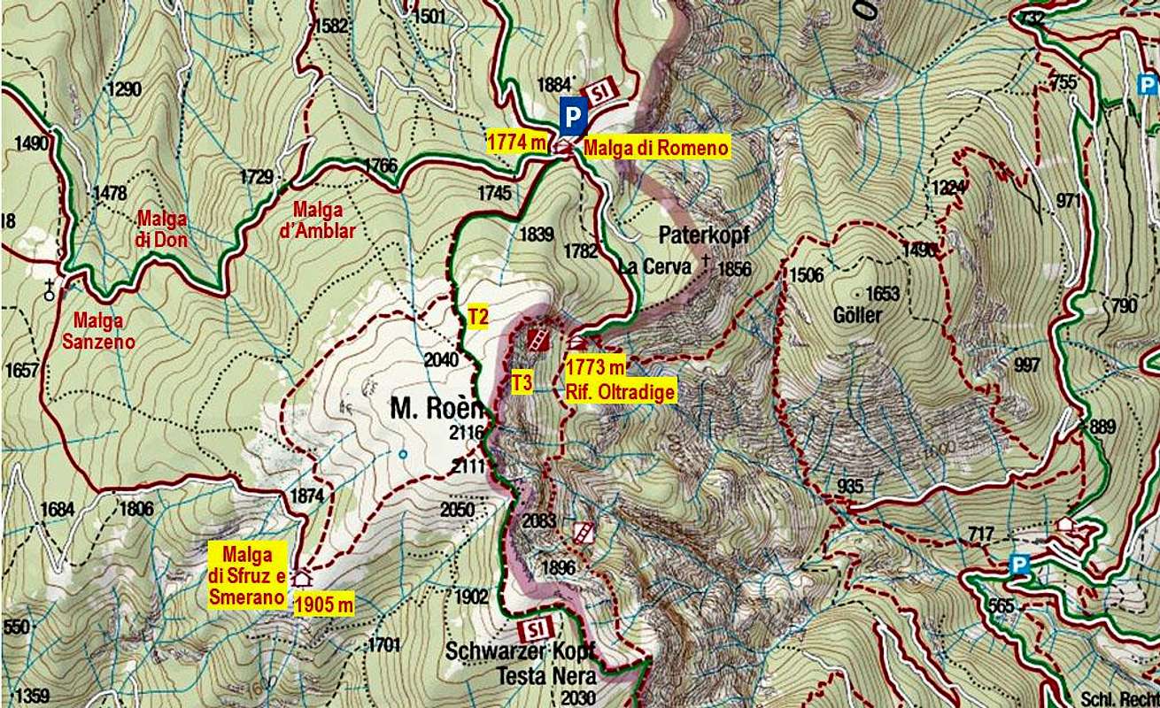
Monte Roen can be reached quite easily from more far away, but there are also very close trailheads. One would naturally think of hiking on top from the Passo di Mendola. It can be done, towards the south also runs a road till the ski resort, but from there it's still some good 3 hours of a hike, until you reach the top.A better option is to take the mountain road from Amblar (near Cavareno), which brings you on the broad Malga di Romeno / Malga Roen, 1774 m. Till the meadow on 1501 m the road is nice and asphalted, higher it's macadam. Another access road starts in Don village. It goes fist up to the Malga Sanzeno and then eventually further up to Malga di Romeno.
Also the Malga di Smareno e Sfruz, 1905 m, lying SW of the summit, is reachable by a mountain road. But I have no information if it's opened for public traffic.
Finally there are two parking places on the eastern side of Monte Roen. Above the Tramin town you can park on some 700 m and also above the Kaltern lake on some 700 m. There are mountain roads going a bit further up, but not sure if opened publicly. More towards the south from above Tramin a windy, narrow mountain road goes up towards the main ridge. In its lower parts you can park even above 1000 meters.
Monte Roen Hiking Ascents
1. Normal route from Malga di Romeno, 1774 m. This is one of the shortest and easiest ascents. From the hut you follow the path No. 500, going soutwards. It starts ascending immediately, first by a good cart road, later it continues by a good, broad path. It's all the time easy (mostly T1) and not too steep. In winter very apropriate for skiing. 50 min.
In the ferrata
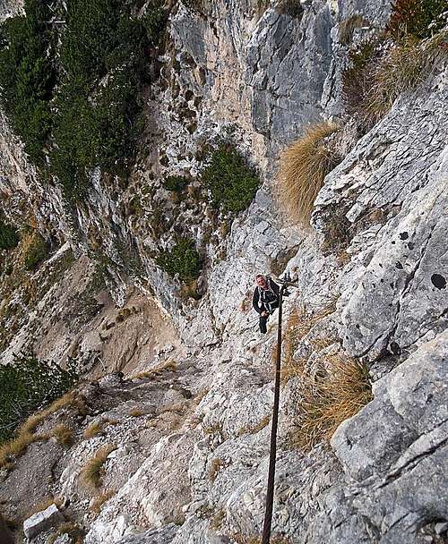
In the ferrata
3. Via del Camosci / Gamsensteig. Below the vertical summit walls this marked path crosses the whole eastern wall of Monte Roen. Obviously it's a hunters route, now secured for hikers visits (No. 560). The route starts at Rifugio Oltradige / Ueberetscher Huette, 1773 m, and goes in some ups and downs all the time southwards. On a few places it's secured (ask for condition of devices in the hut). Finally the route ascends up on the main ridge, where we turn sharp right, ascend first the summit of Testa Nera / Schwarzer Kopf, 2030 m, and then continue northwards on the main summit. Difficulty is supposedly T3, some 2 h 30 minutes from the mountain hut.
4. Normal route from Malga di Smareno e Sfruz, 1905 m. This is even a shorter (and equally easy) hike than #1 above. But providing that you can drive all the way up on the alpine pasture. 30 min.
5. The ascents from the eastern side. All the marked routes are much longer and higher, count with some 4 hours for ascending on top.
Mountain huts
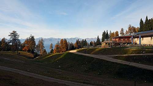
Malga di Romeno
- Malga di Romeno / Monte Roen hut, 1774 m. Reachable by car.
- Rifugio Oltradige / Ueberetscher Huette, 1773 m. Reachable on foot in 15 minutes.
- Malga di Smareno e Sfruz, 1905 m. Shepherds hut, the road reaches the pasture, but check if it's opened.
- Rifugio Mezzavia / Halbweghuette, 1585 m. Near the upper station of ski lifts, half way on the route from Passo Mendola.
Gangolf Haub - Nov 5, 2017 6:14 am - Voted 10/10
Not the highest of the Nosberg GroupNice and interesting addition. I have often wondered about Mendelkamm. However, the first sentence is not correct. The highest mountain of the Nonsberg Group is Große Laugenspitze. Even if it looks like it should belong to the Ortler Group it doesn't. Geotectonics: the peradriatic fault divides the Nonsberg from the Ortler Group.
Vid Pogachnik - Nov 5, 2017 6:56 am - Hasn't voted
Re: Not the highest of the Nosberg GroupHmm? That's interesting. But I guess there must be also different interpretations. The Wikipedia says about Mendelkamm: "Der Mendelkamm verläuft vom Gampenpass (1518 m s.l.m.) südlich von Meran, der den Kamm vom Laugen trennt und das Etschtal mit dem Deutschnonsberg verbindet, zunächst in einem leichten Bogen nach Südosten...". And later in the same article: "...zum höchsten Berg des Mendelkamms, dem Roen (2116 m), an.". Also I found that some articles attribute Monte Luco / Laugenspitze to the Ortler group, some others to the Mendelkamm. And finally - there are many cases where geographical grouping of mountains does not follow the geological evidence. For example: half of the Karawanks should geologically belong to Austroalpine and only the other half to the Southern Alps. So, I'm a bit confused now and would still prefer to wait a little with changing that first sentence. Thanks for your review! Best, Vid
Gangolf Haub - Nov 5, 2017 11:35 am - Voted 10/10
Re: Not the highest of the Nosberg GroupHehe, you have the same problem that I have, when I put Laugenspitze in the Ortler Group and Matthias Zehring told me I was wrong. I looked it up and found that Hofmahdjoch is the separation between both groups. I think I found it in Alpenvereinsführer Ortleralpen.
Vid Pogachnik - Nov 5, 2017 11:38 am - Hasn't voted
Re: Not the highest of the Nosberg GroupOK, I trust you and Matthias - so, I'll do the correction in the text. Cheers, Vid
Gangolf Haub - Nov 5, 2017 11:42 am - Voted 10/10
Re: Not the highest of the Nosberg GroupHere you go https://de.wikipedia.org/wiki/Laugenspitze