
-
 5136 Hits
-
 78.27% Score
-
 9 Votes
|
|
Mountain/Rock |
|---|---|
|
|
37.62851°N / 107.60588°W |
|
|
Hiking, Mountaineering |
|
|
Spring, Summer, Fall |
|
|
13540 ft / 4127 m |
|
|
Overview
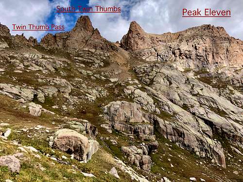
Peak Eleven
Peak Eleven is infrequently summited 13er with a relatively easy access from popular Chicago Basin. Peak Eleven is surrounded by many peaks including 14ers: Sunlight Peak, Mt. Eolus and Windom Peak. It is not a high peak by Colorado standards and it is not on a priority list for visitors to Chicago Basin who seek popular 14ers first. However, it provides solitude, nice scramble and excellent views in all directions.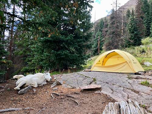 Campsite in Chicago Basin
Parent Lineage: Sunlight Peak![Durango Silverton Trail]() Durango Silverton Trail
Durango Silverton Trail![Frequent mountain goats]() Frequent mountain goatsThere are several options to get to Chicago Basin: the easiest is to take the historic Durango Silverton train and exit at Needleton. However, this train operates only seasonally and during certain times such as summer 2018 it may not take backpackers. Expect about 5 miles hike in into Chicago Basin from the train stop. Approach on foot to Chicago Basin: The closest way is from Purgatory Flats Trail. From downtown Durango, head north on Highway 550 approximately 25 miles to Tacoma Drive. Look for the entrance to Durango Mountain Resort on the left side of the road, and Tacoma Drive is directly from the entrance on the right (east) side of 550. Take a right onto Tacoma Drive, also signed for Purgatory Creek TH and follow the road for less than 1/4 mile and you will see a dirt parking lot on the left next to a small lake. Park here (free) and the TH is right across from the parking lot next to a house.
Frequent mountain goatsThere are several options to get to Chicago Basin: the easiest is to take the historic Durango Silverton train and exit at Needleton. However, this train operates only seasonally and during certain times such as summer 2018 it may not take backpackers. Expect about 5 miles hike in into Chicago Basin from the train stop. Approach on foot to Chicago Basin: The closest way is from Purgatory Flats Trail. From downtown Durango, head north on Highway 550 approximately 25 miles to Tacoma Drive. Look for the entrance to Durango Mountain Resort on the left side of the road, and Tacoma Drive is directly from the entrance on the right (east) side of 550. Take a right onto Tacoma Drive, also signed for Purgatory Creek TH and follow the road for less than 1/4 mile and you will see a dirt parking lot on the left next to a small lake. Park here (free) and the TH is right across from the parking lot next to a house.![Ramp up Peak Eleven]() Ramp up Peak Eleven
Ramp up Peak Eleven![Crux move on Peak Eleven]() Crux move on Peak Eleven
Crux move on Peak Eleven
Class: mostly 2 (very short section of class 3)
Weminuche Wilderness: At 3/4 the size of Rhode Island, the Weminuche Wilderness is the largest wilderness area in Colorado. The Weminuche spans the Continental Divide, North America's geological backbone, with its headwaters diverted to both the Pacific and Atlantic oceans. With an average elevation of 10,000 feet above sea level, the Weminuche is rugged country.
Guide to the Colorado Mountains with Robert Ormes (sort of a Bible of Colorado Mountains) provides a couple of brief mentions of Peak Eleven: "Twin Thumbs and Peak Eleven are both climbed from the col between them, due north from the Twin Lakes. Peak Eleven goes by contouring around Point 13,460' on the north."
Nearby Peaks:
- North Twin Thumbs (unranked) 0.17 miles
- South Twin Thumbs (unranked) 0.18 miles
- Needle Ridge (unranked) 0.22 miles
- Glacier Point (unranked) 0.50 miles
- Sunlight Peak 14er 0.55 miles
- Peak Eighteen (unranked) 0.60 miles
- "Sunlight Spire" 0.72 miles
- Peak Twelve 0.77 miles
- North Eolus 14er 0.85 miles
- Windom Peak 14er 0.92 miles
- Knife Point 0.93 miles
- Mt. Eolus 14er 1.02 miles
- Monitor Peak 1.19 miles
- Peak Thirteen (unranked) 1.32 miles
- Jupiter Mountain 1.34 miles
- Peak Ten (unranked) 1.38 miles
- Little Finger (unranked) 1.44 miles
- Peak Sixteen (unranked) 1.51 miles
- Gray Needle (unranked) 1.53 miles
- Animas Mountain 1.62 miles
- Peak Fifteen 1.64 miles
- Jagged Mountain 1.68 miles
- The Index (unranked) 1.83 miles
- Turret Peak 1.86 miles
- Grizzly Peak C 1.96 miles
Getting There
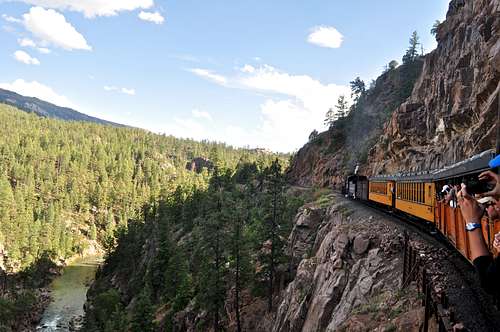 Durango Silverton Trail
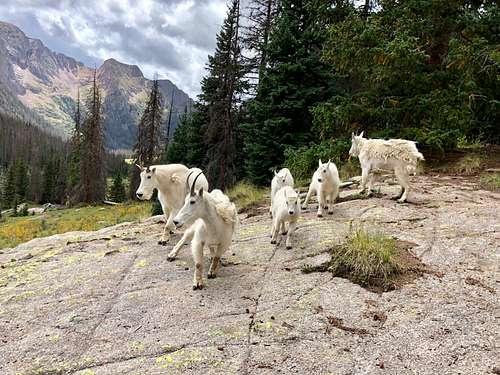 Frequent mountain goats
Trail: The trail is easy to follow passing by a registration sign for the Weminuche Wilderness Area. After the sign, the trail descends down a number of switchbacks and then it follows along side Purgatory Creek. After about a half-mile, the trail crosses over Purgatory Creek on a make shift stone pathway. After crossing the creek, the trail gets steeper for a bit as travels through a number of aspen grooves. After about 1.2 miles, the trails begins a series of switchbacks as it makes a final descent to Purgatory Flats. At Purgatory Flats the trail splits left and right. Turn right here and head downstream Cascade Creek and towards Animas River. It is about 4.5 miles to get to the bridge over Animas River.
Animas Trail: It is about 7 miles from the bridge over Animas to the turn off for Chicago Basin. The trail continues upstream along Animas River on an easy to follow trail. It gently ascends, it is mostly in wooded areas and there are multiple sites for camping here. It is hard to spot the train since it is wooded. The turn off for Chicago Basin is signed and from the intersection is about another 4.5 miles. The trail turns east here and it gets steeper. Chicago Basin is beautiful area, wide and surrounded by many mountains. Expect to see abundant wildlife especially mountain goats and deer.
Route
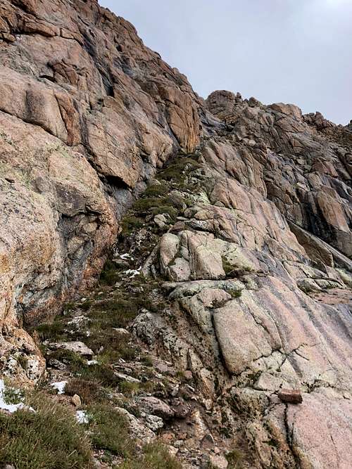 Ramp up Peak Eleven
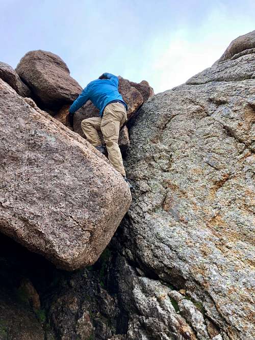 Crux move on Peak Eleven
As any mountain there are many possibilities to get up it. I will describe the standard and most likely the easiest route up.
I would like to also mention that also our group came from Ruby Lake basin, this is not an advisable approach. Our objective was for one of our party members to complete 13ers and he was missing only Peak Fifteen and Peak Eleven. Therefore images of Twin Thumbs Pass from the north.
Practical approach is via Chicago basin on a nice trail leading all the way to Twin Lakes and from here ascend a mostly grassy slopes to the sub peak of Peak Eleven to a start of a ramp leading east and up. There is a large boulder (see image) you have to negotiate (crux of the route) and pass the route there is a gully with loose rock, non-technical leading to the summit.
There was a small cairn on the summit, summit register was open and empty. The views spectacular.
Red Tape
Peak Eleven is located in the Weminuche Wilderness, so wilderness rules apply. Leave no trace.
ALL VISITORS
-- Group size is limited to no more than 15 people per party. -- Camping is prohibited within 100 feet of any water source. -- Camping and all campfires are prohibited at the following locations: 1. within 200 feet of Archuleta Lake, Fourmile Lake, and West Ute Lake 2. within 1/2 mile of the north shore and 1/4 mile of other shores of Emerald Lake 3. within 1/4 mile of Little Emerald Lake 4. between the shore and Flint and La Osa Trails at Flint Lake; and within 200 feet of the west and north shores 5. in Needle Creek drainage at Twin Lakes 6. in the hot springs area at West Fork (Rainbow) -- Campfires are also prohibited in all of Needle Creek Drainage (including Chicago Basin) and Vestal Basin. -- Do not shortcut switchbacks. -- Pets must be under verbal control or leashed at all times. -- Disposal of human waste and wash water is prohibited within 100 feet of any water source. -- As with all designated Wilderness areas, mechanical transportation (including wagons, game carts, wheelbarrows, bicycles, or other vehicles) is prohibited.
When to Climb
The approach is hard and obviously the easiest time to climb Peak Eleven is in the summer or early fall. Other seasons provide difficult and long approach and winter there is a high avalanche danger.
The train between Durango and Silverton operates only seasonally during the summer and early fall, winter means at least 16 miles of backpacking in.