
-
 3861 Hits
-
 76.66% Score
-
 7 Votes
|
|
Mountain/Rock |
|---|---|
|
|
37.60080°N / 105.49325°W |
|
|
Alamosa&Huerfano |
|
|
Hiking, Mountaineering |
|
|
Spring, Summer, Fall |
|
|
13577 ft / 4138 m |
|
|
Overview
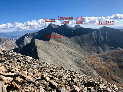 Peaks as seen from California Peak
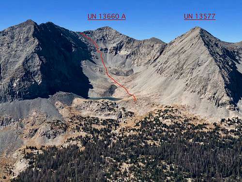 UN 13577 and UN 13660 A
Colorado Thirteeners 13,800 to 13,999 feet From Hikes to Climbs by Gerry Roach & Jennifer Roach briefly mentions the peak in combination with California Peak, via South Ridge. "From Lily Lake's north side, hike 0.25 miles west-northwest of the lake to 12,600 feet. Climb 0.25 miles north up a steep talus slope and reach the east ridge of UN 13577 at 13,440 feet (Class 2). Climb 0.1 miles west-northwest to the summit of Point 13,577 and enjoy grand vista. Point 13,577, your bonus peak, is "Tri" -one of Colorado's 300 highest peaks. From Point 13, 577, hike 0.4 miles north to Point 13,420, an unranked summit, then hike 0.8 mile north-northwest to California's summit (Class 2)".
Colorado Rank: 205 (tricentennial peak)
Line Parent: Unnamed 13660
Class: 2 (scree)
Nearby Peaks:
- Unnamed 13660 A 0.46 miles
- California Peak 0.98 miles
- Ellingwood Point 1.26 miles
- Twin Peaks A 1.59 miles
- Blanca Peak 1.67 miles
- "Huerfanito" 1.94 miles
- Iron Nipple 2.16 miles
- Little Bear Peak 2.37 miles
- Huerfano Peak 2.48 miles
Getting There
Lower Huerfano Trailhead: Great if doing a loop California Peak, UN 13577 and UN 13660 A.Take exit 52 from Interstate 25 north of Walsenburg and go 0.3 miles south towards Walsenburg. Turn west onto Colorado 69, go 25.1 miles northwest to Gardner (not much here) and continue for additional 0.7 miles to the far side of town. Turn west onto the Redwig spur of Colorado 69 (paved) - well signed for Mosca Pass, Lily Lake TH and Huerfano TH. If coming from the north of 69 (from Westcliff), there is no sign for Lily Lake.
Go straight, the road eventually changed into a dirt road. The turn offs are well signed. The part of a road passes through a private land, do not trespass outside the road. The last 4 miles of the road become rougher and it is better to have a high clearance vehicle (Subaru could make it). The trailhead for Lower Huerfano/Zapata trail is well marked, there is a small parking lot (only about 2 cars, but just about 100 meters higher up is plenty of parking). The mile marker from the turn off from Colorado 69 is 21.2.
Upper Huerfano Trailhead: This trailhead is at 10,680 feet. From the Lower Huerfano Trailhead at mile 21.2, continue south on the road and reach the trailhead at mile 22.3. There are multiple campsites along this last mile of the road. The road gets steeper and rougher here - definitively high clearance 4 WD vehicle. The trailhead is large and well signed. ![California Mountain]() California Mountain as seen from the summit of UN 13577
California Mountain as seen from the summit of UN 13577![UN 13577]() UN 13577 with an unnamed lake above Lily Lake As any mountain there are many ways up it. I will describe the route as I took it, and I believe this route avoids the scree section on the way up as much as possible. And on the way down, you can try to "ski" the scree as much as possible.
I chose a combination with California Peak and UN 13660 A to try to address all peaks in the area.
UN 13577 with an unnamed lake above Lily Lake As any mountain there are many ways up it. I will describe the route as I took it, and I believe this route avoids the scree section on the way up as much as possible. And on the way down, you can try to "ski" the scree as much as possible.
I chose a combination with California Peak and UN 13660 A to try to address all peaks in the area.
Route
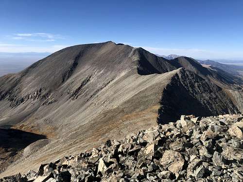 California Mountain as seen from the summit of UN 13577
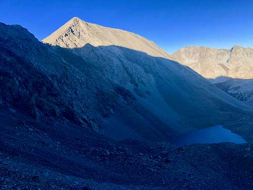 UN 13577 with an unnamed lake above Lily Lake
 Start: Lower Huerfano Trailhead. Follow up a nice trail (class 1) to the saddle and then follow the North Ridge up California Peak. The trail disappears on this section, but the route finding is obvious. Once on the summit of California Peak look south and the route is obvious. Hike on a ridge - easy, class 2 going over unranked point 13440, descent slightly and continue up the main summit of Unnamed 13577. There was a small cairn and summit register. The views from its summit are spectacular.
I chose to descend southwest ridge and continue towards UN 13660 A. Again, the route finding was obvious and no more than 2/2+ in difficulty.
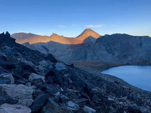
![Sunset from Lily Lake]() Sunset from Lily Lake
Driving the 4 WD road, camping and hiking are free. Mind the private land along the road (do not camp on private land).
Sunset from Lily Lake
Driving the 4 WD road, camping and hiking are free. Mind the private land along the road (do not camp on private land).
I started to use Gaia application on my mobile phone. Easy to use.
Red Tape
 Sunset from Lily Lake
The peak is located within Sangre de Cristo Wilderness area, so wilderness rules apply.
-- Group size is limited to 25, including pack and saddle stock, with no more than 15 people in any one party.
-- Do not cut switchbacks. Doing so can cause severe erosion.
-- Camping is prohibited within 300 feet of lakes and 100 feet of streams or trails. Obey posted signs prohibiting camping or other activities. Some campsites may be closed to allow the area to recover from overuse.
-- A lightweight camp-stoves are recommended. Campfires should be at least 300 feet from lakes, streams, and trails and built in a manner that minimizes impact. Collect only dead and down wood, that is less than three inches in diameter (if you can't break it by hand, don't use it). Do not build a fire on exposed rock surfaces to prevent scarring. If possible, build fires on a fire blanket or a fire pan.
-- Soap, even biodegradable, pollutes the water. Dispose of wash water at least 300 feet away from any water source.
-- Pack out all garbage. It is NEVER acceptable to bury trash.
-- Bury human waste in a 6 to 8 inch deep hole at least 300 feet away from any open water, trail, or campsite.
-- With increasing visitor use in the Sangre de Cristo Wilderness, the Forest Service is considering a self-issuing permit system. Please contact the San Carlos Ranger District (719) 269-8500.