
-
 4195 Hits
-
 78.27% Score
-
 9 Votes
|
|
Mountain/Rock |
|---|---|
|
|
37.58462°N / 105.46422°W |
|
|
Costilla&Huerfano |
|
|
Hiking, Mountaineering |
|
|
Spring, Summer, Fall, Winter |
|
|
13081 ft / 3987 m |
|
|
Overview
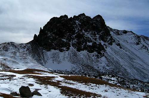 Huerfanito
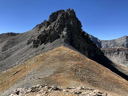 Huerfanito
Guide to Colorado Mountains with Robert Ormes (sort of a bible of Colorado Mountains) briefly mentions the peak: "Little Peak 13,081 sits astride the ridge between giants Blanca and Lindsey. To reach it from Lindsey's 12,500' saddle, contour south and east until well past the towers and then straight north up the slope."
"Huerfanito" combines nicely with Iron Nipple (unranked 13er, but official named) and centennial 13er Huerfano Peak. One can add also 14er Lindsey.
Colorado Rank: 584
Class: 2
Parent Lineage: Line Parent: Blanca Peak Proximate Parent: Mount Lindsey
Nearby Peaks:
- Iron Nipple 0.81 miles
- "Huerfano Peak" 1.40 miles
- Mt. Lindsey 1.07 miles
- Blanca Peak 1.26 miles
- Ellingwood Point 1.56 miles
- Unnamed 13577 1.94 miles
- Little Bear Peak 2.19 miles
- Unnamed 13660 A 2.25 miles
- California Peak 2. 79 miles
- Twin Peaks A 3.01 miles
Getting There
I recommend Upper Huerfano Trailhead for "Huerfanito". Basically, the road is the same, first you reach the Lower Huerfano trailhead - small sign only and tiny parking lot (2 cars?), but a little higher up the road is an opportunity for more parking. I think Subaru and little higher clearance cars can make it to this trailhead. The Upper Huerfano TH I recommend to use 4 WD vehicle and there is a large parking lot, the end of the road. The distance between lower and upper Huerfano trailheads is about 1.1 miles. 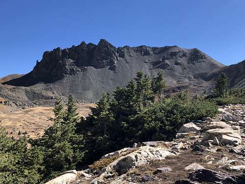 Huerfanito
Lower Huerfano Trailhead: Great if doing a loop California Peak, UN 13577 and UN 13660 A.Take exit 52 from Interstate 25 north of Walsenburg and go 0.3 miles south towards Walsenburg. Turn west onto Colorado 69, go 25.1 miles northwest to Gardner (not much here) and continue for additional 0.7 miles to the far side of town. Turn west onto the Redwig spur of Colorado 69 (paved) - well signed for Mosca Pass, Lily Lake TH and Huerfano TH. (If coming from the north of 69, from Westcliff, there is no sign for Lily Lake, only for Mosca Pass). Go straight, the road eventually changes into a good dirt road. The turn offs are well signed for Huerfano Trailheads. The part of a road passes through a private land, do not trespass outside the road. The last 4 miles of the road become rougher and it is better to have a high clearance vehicle. The trailhead for Lower Huerfano/Zapata trail is well marked, there is a small parking lot (only about 2 cars, but just about 100 meters higher up is plenty of parking). The mile marker from the turn off from Colorado 69 is 21.2.
Upper Huerfano Trailhead: This trailhead is at 10,680 feet, and is a better trailhead for 14er Mount Lindsey, centennial Huerfano Peak, and Huerfanito. From the Lower Huerfano Trailhead at mile 21.2, continue south on the road and reach the trailhead at mile 22.3. There are multiple campsites along this last mile of the road. The road gets steeper and rougher here - definitively high clearance 4 WD vehicle. The trailhead is large and well signed.
Route
As any mountain there are many ways to get up it. I will describe what seemed like the easiest way up avoiding loose rock. However, steep scree is everywhere on this one. Luckily, it went quickly.
From the Mount Lindsey - Huerfanito saddle bypass on the south side of steep cliffs, bypassing these cliffs. Then take a steep gully with loose rock all the way to the saddle. The summit is a small scramble to the west from here. There was a small summit cairn and broken summit register.
Red Tape
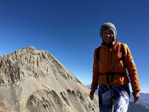 Summit of Huerfanito
The peak is located within Sangre de Cristo Wilderness area, so wilderness rules apply.
-- Group size is limited to 25, including pack and saddle stock, with no more than 15 people in any one party.
-- Do not cut switchbacks. Doing so can cause severe erosion.
-- Camping is prohibited within 300 feet of lakes and 100 feet of streams or trails. Obey posted signs prohibiting camping or other activities. Some campsites may be closed to allow the area to recover from overuse.
-- A lightweight camp-stoves are recommended. Campfires should be at least 300 feet from lakes, streams, and trails and built in a manner that minimizes impact. Collect only dead and down wood, that is less than three inches in diameter (if you can't break it by hand, don't use it). Do not build a fire on exposed rock surfaces to prevent scarring. If possible, build fires on a fire blanket or a fire pan.
-- Soap, even biodegradable, pollutes the water. Dispose of wash water at least 300 feet away from any water source.
-- Pack out all garbage. It is NEVER acceptable to bury trash.
-- Bury human waste in a 6 to 8 inch deep hole at least 300 feet away from any open water, trail, or campsite.
-- With increasing visitor use in the Sangre de Cristo Wilderness, the Forest Service is considering a self-issuing permit system. Please contact the San Carlos Ranger District (719) 269-8500.
When to Climb
Summer and early fall are obviously the easiest times to hike the area with an easy access to Upper Huerfano Trailhead and easy travel on trails and slopes. Early spring and winter are more difficult based on snow conditions. The road is usually snow plowed for only about 12 miles, the additional 10 miles would require a foot approach when road is closed. Always check avalanche conditions if traveling during winter time.
Camping
There is a multitude of primitive campsites along the Huerfano Road. Do not camp in area lower down marked as a private land! You can also sleep at the trailhead. There are no toilet facilities.