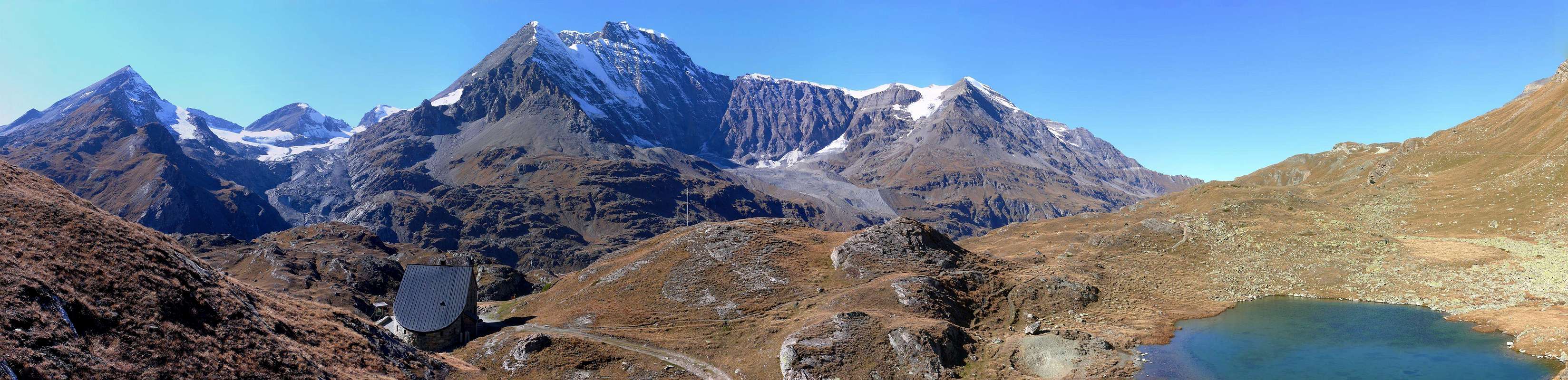
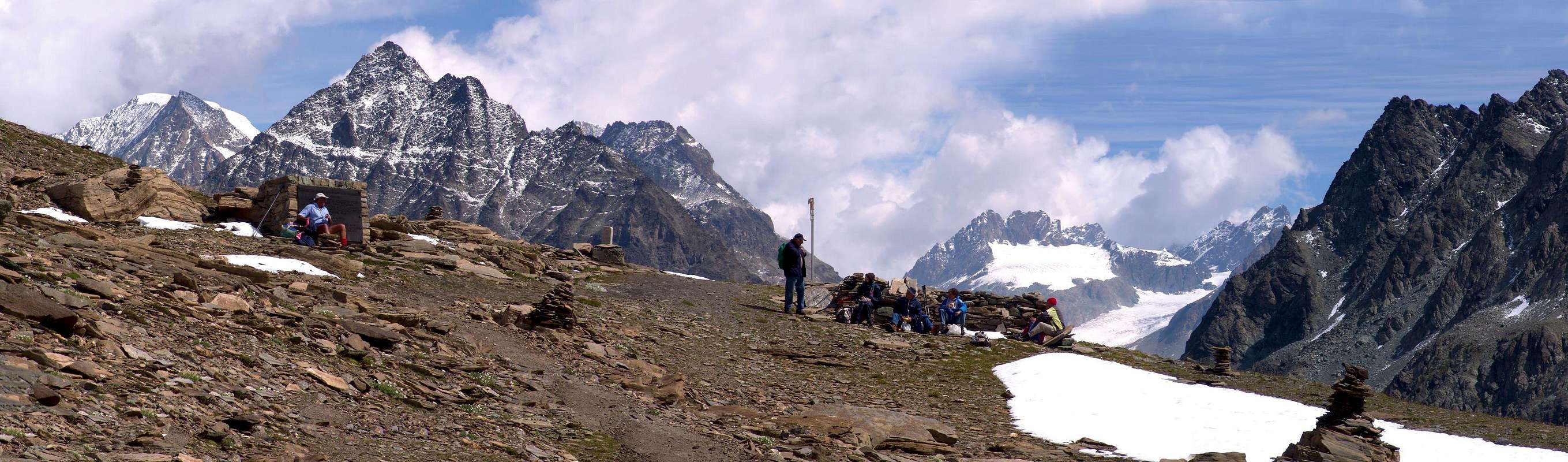
Top with an elongated shape and positioned on the Italian-Swiss border ridge between the Col de By (3.224m) to the West-Southwest and the Fenêtre Durand (2.805m) to the East-Southeast, or between the Tête de la Balme (3.313m) and the Western Spallone (Great Shoulder, 3.446m) of Mont Gelé (3.518m). Under its Northern Slope flows the Glacier du Mont Durand, which flows from the Grand Combin de Grafeneire (4.314m) to the Cabane de Chanrion (2.462m), completely in Swiss territory. On the Southern Side, instead, ancient glaciers have completely retreated and then extinguished, bringing out the Fenêtre Lake (2.711m) just below the homonymous hill. The only recommended routes are is the Normal Route, which climbs from the hill with a slight inclination (30°/33°) along the East-Southeast Ridge or from Rifugio Cabane de Chanrion (2.462 m) in the La Barme valley in Switzerland. Easy to climb over broken and crushed track with a small path (but pay attention at the beginning of the season with high snow and possible frames, usually in the South), presents a magnificent and complete 360 ° view over the whole Alps and with strokes exceptional views of the nearby Combins and the chain that stretches from Mont Gelé to the Punta Fiorio (3.332m), bypassing the various Morion (3.484, 3.500, 3.502, 3.470 meters about and 3.487m, 3.497m) and the Mont Clapier (3.437m). Its toponym, even under the form of mount avrì or ouvert, derives from the Latin "mons apricus" which means open and sunny mountain.
Cima dalla forma allungata e posizionata sulla cresta di confine italo-elvetico tra il Col de By (3.224 m) ad Ovest-sudovest e la Fenêtre Durand (2.805 m) ad Est-sudest, ovvero tra la Tête de la Balme (3.313 m) e lo Spallone Occidentale (3.446 m) del Mont Gelé (3.518 m). Sotto il suo Versante Settentrionale scorre il Glacier du Mont Durand, che dal Grand Combin de Grafeneire (4.314 m) scorre verso la Cabane de Chanrion (2.462 m), completamente in territorio svizzero. Sul Versante Meridionale, invece, antichi ghiacciai si sono completamente dapprima ritirati e poi estinti, facendo emergere il Lago Fenêtre (2.711 m) appena al di sotto dell’omonimo colle. Le uniche vie consigliate risultano la Via Normale, che dal colle risale con leggera inclinazione (30°/33°circa) lungo la Cresta Est-sudest o da Rifugio Cabane de Chanrion (2.462 m) nel vallone di La Barme in Svizzera. Di facile ascensione sopra calcescisti rotti e frantumati con piccola traccia (però prestare attenzione in inizio di stagione con neve alta e possibili cornici, in genere a Sud), presenta un panorama magnifico e completo a 360° su tutto l’arco alpino e con colpi d’occhio eccezionali sui vicini Combins e sulla catena che si allunga dal Mont Gelé alla Punta Fiorio (3.332 m), scavalcando i vari Morion (3.484, 3.500, 3.502, 3.470 metri circa, 3.487 m, 3.497 m) ed il Mont Clapier (3.437 m). Il suo toponimo, anche sotto le forme di monte avrì o ouvert, deriva dal latino “mons apricus” che significa monte aperto e soleggiato.
First Ascents
First on the summit: Abbots Joseph Henry and V. Anselmet, (Aug 03th, 1911).
In winter: Unknown.
Integral traverse from Fenêtre Durand, Mont Avril, Tête de la Balme and Tête du Filon: Osvaldo Cardellina, (Oct 23th, 1983).
Getting There
BY CAR:
From Torino, Milano, etc: Motorway A5. Exit at Aosta Est.
From Switzerland: through the Grand Saint Bernard Tunnel or the namesake pass.
From France: through the Mont Blanc Tunnel or Petit Saint Bernard Pass. It is not necessary to take Motorway A5: you can drive on SS.26, in the direction of Aosta.
BY PLANE:
Aeroporto "Corrado Gex" Saint Christophe (Aosta).
Specific Road from Aosta Town:
From Aosta East exit of the motorway, follow along the SS.27 for the Gran San Bernardo Tunnel After about ten KM turn to the right toward Valpelline (964m), it and turn to the left to get Ollomont (1.335m) and the small built area of Glacier (1.549m), where you must start walking.
Dall'uscita del Casello Autostradale di Aosta Est, proseguire sulla SS.27 in direzione del tunnel del Gran San Bernardo; dopo circa un decina di chilometri svoltare sulla destra verso il Paese di Valpelline (964 m). Dopo averlo superato svoltare sulla sinistra e raggiungere il Paese di Ollomont (1.335 m); proseguire sino alla Frazione di Glacier (1.549 m), dove inizia l'itinerario a piedi.
Approach and Routes
A) - Approach from Glacier Village: with the previous route from "Farinet House" (2.010m) continue Eastward through the trail n°5 until it reaches the farm dirt private road from the Alpage Commune de By into the homonym Basin inserting the same reaching Balme de Bal Pasture (2.128m). From this continues independently as route n°5/TdC to Alpage of Lombardin (2.309m), where returns and concomitant flexing most at Northeast, get to that Thoules, where it ends (2.381m; T/E; 2h'00/2h'20). Continuing further North, initially along the Torrent Fenêtre wade twice the same after 2.620 meters altitude passes a secondary semi dry torrent lead to the opposite side (West). A long diagonal to the North-northeast leads just above the Lac Fenêtre (2.711m; small springs almost everywhere) with stunning views of the West Face of the Mont Gelé and immediately after the Fenêtre de Durand (2.805m; E/F; 3h'00/3h'30). From the large hill, which leads to Val des Bagnes in Switzerland with magnificent view of the North Wall of increasingly Mont Gelé, climb through easy and a little boring East-southeast Ridge through a small path that exceeds unnumbered right a rocky promontory (3.064m; only stretch where you have to be careful), leaving an immediate right (North), a beautiful tiny basin designed to "salle à manger", usually with residual snowfields in altitude of 3.000/10 meters about. Became a track, continues evenly and fairly steep, reaching the unimportant elevation of 3.192 meters and, passing through the midst easy reddish rocks that emerge from the debris at the end, immediately following, with great views, the Summit (E/F; 1h'20/1h'40 by Fenêtre de Durand; EE/F; 4h'30/4h'45 Glacier).
B) - From the Cabane de Chanrion Hut (2.462m) descend to the underlying Alpeggio La Paume (2.342m) and to the Dranse de Bagnes stream, past the bridge (2.182m) up to the Alpe Grand Charmotane (2.255m) from here continue along the valley until you reach the Fenêtre de Durand (2.805m 2h'30/2h'45) where the path coming from the village of Glacier is connected from here following the same itinerary to reach the summit (3.347m1h'20/1h'40).
A) - Avvicinamento dal Villaggio di Glacier: con l'itinerario precedente dalla "Casa Farinet" (2.010 metri circa) continuare verso Est tramite il sentiero n°5 sin a che questo raggiunge la strada poderale dalla Commune de By inserendosi sulla medesima raggiungendo l'Alpe Balme de Bal (2.128 m). Da questa continua autonomamente come sentiero n°5/TdC sino all'Alpe Lombardin (2.309 m), dove ritorna concomitante e, flettendo maggiormente a Nordest, arriva a quella di Thoules (2.381 m; T/E; 2h'00/2h'20). Continuando più a Settentrione, dapprima lungo il Torrent Fenêtre poi guadando due volte il medesimo, dopo la quota 2.620 metri oltrepassa un torrentello secondario portandosi sul versante opposto (Ovest). Un lungo diagonale a Nord-nordest conduce appena sopra il Lac Fenêtre (2.711 m; piccole sorgenti un pò ovunque) con splendida vista sulla Parete Ovest del Mont Gelé e subito dopo alla Fenêtre de Durand (2.805 m; E/F; 3h'00/3h'30). Dall'ampio colle, che porta in Val des Bagnes con magnifica vista sulla Parete Nord sempre del Gelé, salire tramite la facile ed un pò noiosa Cresta Est-sudest per mezzo d'un sentierino non numerato che supera a destra un promontorio roccioso (3.064 metri; unico tratto dove si deve prestar attenzione), lasciando subito a destra (Nord) una bella "conchetta" atta a "salle à manger", in genere con nevai residui in altitudine di 3.000/10 metri circa. Diventato una traccia, continua in modo uniforme ed abbastanza ripido raggiungendo l'elevazione 3.192 metri e, passando in mezzo a facili rocce rossicce affioranti dai detriti nella parte finale, subito appresso, con grandiose vedute, la Vetta (E/F; 1h'20/1h'40 dalla Fenêtre; EE/F; 4h'30/4h'45 da Glacier).
B) - Dal Rifugio Cabane de Chanrion (2.462 m) scendere ai sottostanti Alpeggio La Paume (2.342 m) e al torrente Dranse de Bagnes, oltrepassato il ponte (2.182 m) risalire sino all’Alpe Grand Charmotane (2.255 m) da qui continuare lungo il vallone sino a raggiungere la Fenêtre de Durand (2.805 m 2h'30/2h'45) ove si congiunge il sentiero proveniente dal villaggio di Glacier da qui seguendo lo stesso itinerario raggiugere la vetta (3.347m1h'20/1h'40).
Difficulty
From F to (in winter for BSA= good skiers-mountaineers) F+.
Da F ad (in inverno per BSA o buoni sciatori-alpinisti) F+.
Equipment
For Hiking or with snowshoeing also by ski.
Da Escursionismo o con racchette da neve oppure sci.
Camping
Remember that free camping is forbidden (except for emergency reasons, over 2.500m, from darkness until dawn).
Mountain Conditions
You can get meteo information at the official site of the Regione Valle d'Aosta:
Parents refers to a larger category under which an object falls. For example, theAconcagua mountain page has the 'Aconcagua Group' and the 'Seven Summits' asparents and is a parent itself to many routes, photos, and Trip Reports.

 3263 Hits
 81.08% Score
 13 Votes