
-
 4980 Hits
-
 74.92% Score
-
 5 Votes
|
|
Mountain/Rock |
|---|---|
|
|
37.88833°N / 107.62121°W |
|
|
San Juan |
|
|
Hiking, Mountaineering |
|
|
Spring, Summer, Fall, Winter |
|
|
13310 ft / 4057 m |
|
|
Overview
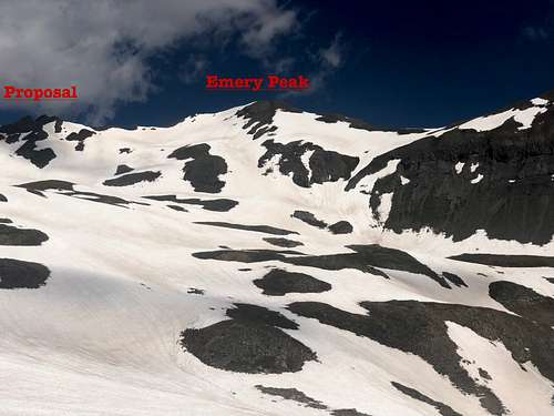 Emery Peak from McCarty Basin
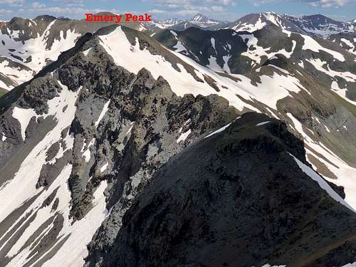 Emery Peak from the summit of Proposal Peak
Line Parent: "Proposal Peak" (the saddle between those 2 peaks is at 13,180 feet).
Class: List of John gives it 3, I thought is was easier.
Drainage Basin: Colorado
Nearby Peaks:
- "Proposal Peak" 0.44 miles
- Bonita Peak 0.62 miles
- Hanson Peak 1.48 miles
- Hurricane Peak 1.82 miles
- Unnamed 13075 1.89 miles
- California Mnt. A 2.04 miles
- Tower Mountain 2.14 miles
- "East Storm" 2.15 miles
- Dome Mnt. A 2.23 miles
- Brown Mnt. A 2.42 miles
- Storm Peak A 2.46 miles
- Macomber Peak 2.82 miles
Getting There
From the historic town of Silverton drive to Eureka. This section of the road is nice and passable for any vehicles, dirt, but flat.The distance from Silverton to Eureka is about 8 miles. There is not much in Eureka, campground and Eureka lodge higher up and below the road.
4WD road from Eureka - you do need high clearance 4WD vehicles above Eureka. The main road goes to Animas Forks and high mountain passes: Engineer and Cinnamon. The area is very popular with ATVs and jeeps in the summer. The road for Emery accessing Emery Peak (also Proposal and Hanson Peak) turns off to the left about 1/2 mile above Eureka and goes through switchbacks and ascends through forest. It goes to a drained Emma Lake (the whole lake drained into mines). As mentioned below, I was not able to drive very high since there was avalanche debris blocking the road.
Route
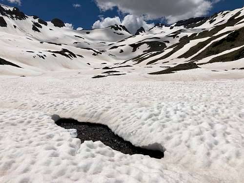 McCarty Basin - unusual amount of snow for July
 Mount Sneffels as seen from the summit of Emery
I tried to choose the least difficult path. Since McCarty Basin was completely snow filled, I was not able to tell whether there are any trails there or not. The snow field lead all the way to the ridge between Proposal and Emery and past the technical difficulties. It did not seem that steep. I never used my ice axe, only hiking poles and crampons. There was a large cornice nearing the ridge, but it was easy to bypass. The summit is large and grassy. I rebuild the cairn. There was no summit register (2019).
Red Tape
There are no fees to drive 4 WD roads, park and hike.
When to Climb
Summer is obviously the easiest time, early fall would be great too. Winter means a longer access (the road is usually snow plowed to Eureka) and high avalanche danger. Spring in stable conditions may be good as well and approach on skis. McCarty Basin looks like a nice place for skiing, but always check avalanche conditions!
Camping
If snow free, McCarty Basin would be a great place to backpack. There are many developed camping areas in Silverton area. Eureka is the closest one. Click here for more information.
External Links