
|
|
Mountain/Rock |
|---|---|
|
|
37.40970°N / 108.1023°W |
|
|
La Plata and Montezuma |
|
|
Hiking |
|
|
Summer, Fall |
|
|
12286 ft / 3745 m |
|
|
Overview
Gibbs Peak is located in the southern La Plata Mountains in the San Juan Range. The summit straddles La Plata and Montezuma Counties.
Despite its small prominence of just 386’, Gibbs Peak benefits from being easily accessible from nearby Durango, and offers the opportunity for a loop hike hitting three other lower summits further south – Star Peak 11,870’, Madden Peak 11,972’, and Parrott Peak 11,857’.
Only minor scrambling is required to reach the summit. Gibbs Peak is reached mostly by a steep forest road. Passenger cars can make it to a parking area at 9,130’ at the start of the road along Bedrock Creek. It is a pretty rough 4WD road, and it is advisable to park at the base of the road instead of driving further up.
Gibbs Peak is best hiked between June and early November. It all depends on the snowfall. The La Plata Mountains are the furthest southwest of the Rocky Mountains, and the closest Rocky Mountain peaks to the Phoenix metro area (7 hours of drive time from Central Phoenix). Start hikes early to avoid afternoon thunderstorms.
 Gibbs Peak from the south.
Getting There
Gibbs Peak is best approached from the 124 Forest Road in La Plata Canyon. This is accessed just north of Hesperus, Colorado and 11 miles west of Durango from Highway 160.
The 124 Road is paved for the first four and a half miles, and then becomes well graded dirt. Once you leave the pavement, it is less than 3 miles to the starting point. Once you pass Kroeger Campground it is about a mile and a quarter.
For the loop hike, if you have two cars, it makes sense to park one car at the road along the Madden Creek, which is a half a mile past Kroeger Campground; and park a second car at the road along Bedrock Creek, three quarters of a mile further.
Route
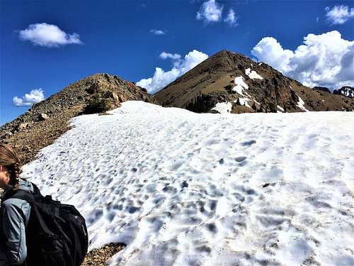
Once at the starting point at the road along Bedrock Creek, continue up the road for 1 ½ miles gaining about 1,000’. There is turn-off to the left that skirts up the ridge. There are some off-shoots, but just take the road going up. It is pretty straight-forward. A little over 3 miles from the starting point on the 124 Road, you reach 11,000’ and the road starts switch-backing up and eventually becomes a trail. You’ll need to scramble up a rocky section below the summit. It is pedestrian scrambling for the Rocky Mountains. The summit is easily reached from the top of the scrambling section.
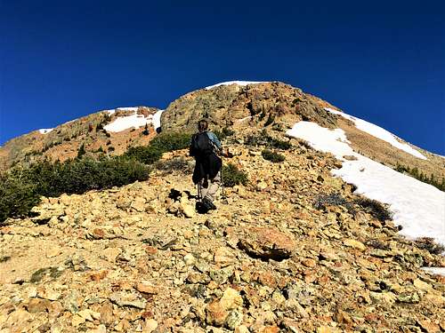 Approaching the rocky section below the summit
Total one-way distance is a little over 4 ¼ miles, gaining about 3,140’.
You can descend the way you came or do a loop hike. This is where a hike up Gibbs Peak has tremendous appeal. The loop hike is 11 ¾ miles. However, it is easy to shuttle, as noted above, which would make it about an 11-mile loop.
For the loop, descend Gibbs Peak and continue on the ridge ahead going southbound. You’ll continue up and down a bit, and after 1 ¾ miles you’ll reach the summit of Star Peak 11,870’. Descend Star Peak and stay on the ridge top going up a lower summit of Star Peak. Descend down to a saddle and go up Madden Peak 11,972’, less than a mile from Star Peak. Descend Madden Peak and you can hike up Parrott Peak 11,857’. At the saddle between Madden Peak and Parrott Peak, you can see a road below. The road is 1,100’ below the saddle. However, the descent isn’t too bad.
 Looking back up from the descent from the saddle between Madden Peak and Parrott Peak
Once on the road, continue down until it turns left and heads onto another ridge-line. There is little bit of uphill hiking as the road winds around the ridge, but then the road descends back to the 124 Road.
If doing the full loop hike with all four summits and the ups and downs, it is about 4,600’ of total elevation gain. If hiking back up the 124 Road, add another 100’.
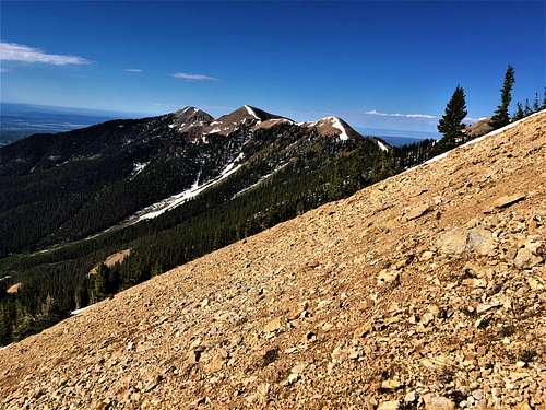 View south to Star Peak, Madden Peak, and Parrott Peak from just below Gibbs Peak
Red Tape
The only red tape is related to road conditions. The road will be closed in winter months, and generally re-opens in late spring depending on snow conditions.
Camping
There is plenty of camping opportunities in the La Plata Range, with a few campsites along the 124 Road, most notably Snowslide and Kroeger, which are both within five minutes of the starting point. Target Tree Campground is also a good spot located seven miles west on Highway 160 from the junction with the 124 Road.