
-
 6554 Hits
-
 76.66% Score
-
 7 Votes
|
|
Mountain/Rock |
|---|---|
|
|
37.85690°N / 108.0117°W |
|
|
Dolores&San Miguel |
|
|
Hiking, Mountaineering, Scrambling |
|
|
Spring, Summer, Fall, Winter |
|
|
13498 ft / 4114 m |
|
|
Overview
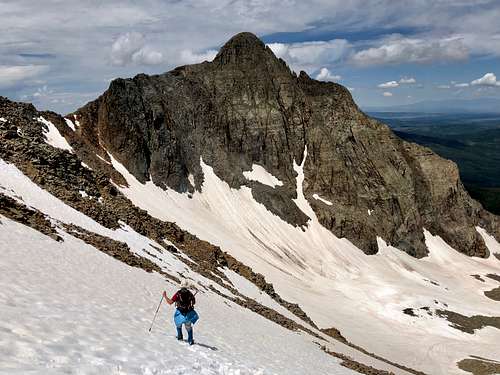 Fowler Peak as seen from the descent of 13540
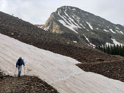 Fowler Peak as seen from the trail up to Rock of Ages
 Why so many different names? The peak used to be unnamed, then was given an unnofical name "Big Bear Peak". There was a proposal to commemoratively name two unnamed thirteen thousand foot peaks that straddle the border of Dolores and San Miguel counties between Navajo and Elk Creek Basins after two prominent American mountaineers, Charlie Fowler and Christine Boskoff.
Charlie Fowler and Chris Boskoff were residents of Norwood at the time of their tragic deaths during an alpine climb in Tibet in 2006. Part of the attraction of the peak naming proposal is the proximity of the peaks to each other, symbolizing the partnership in life and death of Charlie Fowler and Chris Boskoff and that proposed Boskoff Peak can be seen from the town of Norwood where they resided. The Bill of renaming those 2 peaks was passed in January of 2019.
Colorado Rank: 256
Class: 4
Wilderness: Lizard Head
The area is named for a prominent rock formation said to look like a lizard's head. Lizard Head itself is 13,113 feet (3,997 m) and is a volcanic spire of crumbling rock. The summit of Lizard Head Peak is one of the Colorado's most dangerous and difficult climbs. The area includes three prominent fourteeners: El Diente 14,159 feet (= 4316 m), Wilson Peak 14,017 feet (= 4272 m) and Mount Wilson 14,246 feet (= 4342 m).
Parent Lineage: Unnamed 13540
Nearby Peaks:
- Unnamed 13540 B 0.58 miles
- Boskoff Peak 1.06 miles
- El Diente Peak 1.27 miles
- Wilson Peak 1.48 miles
- Mount Wilson 1.64 miles
- Gladstone Peak 1.71 miles
- Lizard Head 3.64 miles
- Dolores Peak 4.76 miles
Getting There
From Ridgway, take CO 62 towards Telluride. Drive Dallas Divide and into Placerville, turn left onto CO 145. Drive 6.5 miles and turn onto well signed Silver Pick Road. This is easy 4 WD road, high clearance 2 WD should be fine. Drive 4 miles to an intersection and bear right onto FR 622 (all turns are marked; this is the standard winter closure). Drive 2.2 miles and bear right onto FR 645. Cross a small stream and continue to Rock of Ages Trailhead at 10,300 feet.
Route
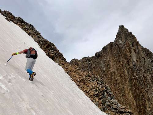 To the saddle
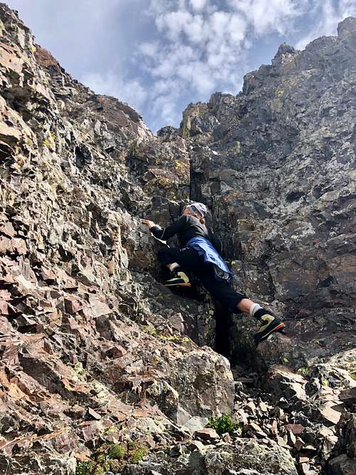 Class 4 section
We could see an old road here and there between the snow, but we chose to directly ascend the easy snow slopes. I was happy for so much snow covering the talus and scree. We continued to ascend all the way to the saddle between Fowler Peak and UN 13540. We stayed mostly on the ridge of Fowler Peak, occasionally dropping on its south side, until we found the ascend gully (pretty obvious). There was a lot of loose rocks on easier sections, and the steeper sections had some solid holds. Scramble was easy. Above the 4th class section was an anchor for rappelling. I thought it would be hard to pull the rope without getting hit by rocks. The rest of the ascent was easy. The summit offered great views. There was a cairn and summit register. We retraced out way back to the saddle and went onto 13540.
Red Tape
Parking at Silver Pick Trailhead is free. Hiking the trails and climbing the mountain too. Fowler Peak is located in the Lizard Head Wilderness area, so wilderness area rules apply.
Motorized equipment and equipment used for mechanical transport is generally prohibited on all federal lands designated as wilderness. This includes the use of motor vehicles, motorized equipment, bicycles, hang gliders, wagons, carts, portage wheels, and the landing of aircraft including helicopters, unless provided for in specific legislation.
ALL VISITORS
It is prohibited to enter or be in the area with more than 15 people per group, with a maximum combination of people and stock not to exceed 25 per group.
It is prohibited to build, maintain, or use a campfire: 1) within 100 feet of any lake, stream or National Forest System Trail; 2) above tree line; or 3) within Navajo Basin.
It is prohibited to store equipment, personal property, or supplies for longer than 3 days.
It is prohibited to possess a dog that is not under control, or that is disturbing or damaging wildlife, people, or property. Note that the term "under control" is defined as the dog being leashed, and/or under direct verbal control by the dog's owner or handler at all times.
When to Climb
The best time to climb this peak is when the "school bus basin" is still covered with snow - early summer. This avoid ascending loose and nasty scree and talus. Obviously you can climb at any time, winter and early spring pose a high avalanche danger.
Camping
You can sleep at the parking lot - Silver Pick Trailhead. There are several primitive campsites along the road to the parking road as well. Developed campgrounds - the closest one would be at Wood Lake, for more information click here.
External Links
- Fowler Peak on List of John
- "Big Bear Peak" on 13ers.com
- Fowler Peak on peakbagger
- Lizard Head Wilderness