
-
 8297 Hits
-
 76.66% Score
-
 7 Votes
|
|
Mountain/Rock |
|---|---|
|
|
37.79346°N / 107.6286°W |
|
|
San Juan |
|
|
Hiking, Mountaineering |
|
|
Spring, Summer, Fall, Winter |
|
|
13340 ft / 4066 m |
|
|
Overview
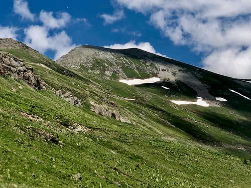 Kendall Mountain - as seen from the road, south slopes
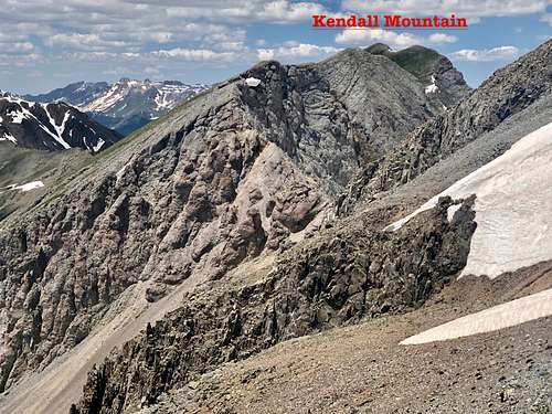 Kendall Mountain - east ridge as seen from the slopes of Kendall Peak
Silverton area is a popular summer destination and it is surrounded by many peaks. Expect some jeeps and all terrain vehicles on the 4 WD Kendall Mountain Road. If having more time add group of 13ers above Highland Mary Lakes - incredible scenic area.
Kendall Benchmark is an easy summit with a rough 4 WD road leading to its summit. There is even a running race up it called Kendall Mountain Run, but runners are racing up the unranked Benchmark and not the ranked mountain, which is higher and there are no established trails up the Kendall Mountain.
Colorado Rank: 363
Parent Lineage: Kendall Peak
Class: 2
Nearby Peaks:
- Kendall Peak 0.71 miles
- Kendall Benchmark 0.73 miles
- Little Giant Peak 1.65 miles
- "Mountaineer Peak" 1.88 miles
- King Solomon Mnt 2.03 miles
- Mt. Rhoda 2.30 miles
- Unnamed 13109 2.48 miles
- Whitehead Peak 2.63 miles
Getting There
Silverton is easy to get too - located along beautiful and scenic Million Dollar Highway.
Kendall Mountain Road (County Road 33) is open seasonally - usually from July till October (first big snow fall). The road is pretty rough and passable only to high clearance 4 WD vehicles. It is popular to also hike up this road, or run up it. The length is is 9.5 miles if one starts from Silverton. The road loops around the southern face of Kendall Benchmark and ascends initially through trees and later through exposed road often with patches of snow year round and large boulders higher up. There are several avalanche chutes here, so if you decide to explore this road during the winter, check the avalanche conditions. I have skied it a few times when the conditions were safe.
Route
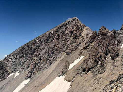 Cliffs on the east side of Kendall Mountain
 Grenadiers
My route started with hiking up the road - Kendall Mountain Road. I left the road just below the Kendall Benchmark where it starts to drop off slightly. There was a foot path leading to the summit of Benchmark. Even though the slopes are south facing, there was still plenty of snow in late July and the road was un-passable to any vehicles for this reason. I descended the Benchmark back towards the road and from the saddle between the Kendall Benchmark and Kendall Mountain I chose the easiest path up - there are no trails here. The walking was easy, mostly on gravel, snow and grass. The summit of Kendall Mountain has 2 different high points, and it was hard to know which one is higher. I walked over both. The first summit had a broken cairn, the other one was unmarked. There was no summit register (2019). It was tempted to continue east/south east towards Kendall Peak on what appeared as some easy slopes, but I knew from my previous visit that the west side of Kendall Mountain ends up with steep cliffs just above the Titusville Mine. I descended south facing slopes, mostly grass and little gravel section covered by snow fields back towards the road and continued now on snow covered road to Titusville and up the steep gully leading to south ridge of Kendall Peak. I checked those cliffs from here and was happy I chose to descent back to the road (see photo).
Red Tape
There is no red tape. Driving the 4 WD road, camping along, hiking are all free. There are some old mines, e.g. Titusville mine you are free to explore. Titusville is a closed mining claim and it overseen by Bureau of Land Management.
When to Climb
Summer and early autumn are the easiest since the road is snow free and you can drive relatively high if you have ATV (all terrain vehicle) or high clearance 4 WD car. The road has some rough sections and I drove only part of the way to the intersection with Deer Park Road. 2019 was a snow rich year and even in late July, there was still a lot of snow on the road, and it was not passable higher up. Winter poses a high avalanche risk, but if conditions stable you can consider a climb straight up from Silverton up Swansea Gulch. Just keep in mind the unstable Colorado snow and very high avalanche danger. Always check for avalanche conditions prior venturing out - information here.
Camping
There are primitive camping sites along the 4 WD road, and even at the start of the rough 4WD road if you have only a low clearance vehicle. These sites are free.
Otherwise Silverton offers plenty of accommodations and has some developed campgrounds. Very popular camping sites are at Molas Lake and along South Mineral Road - multiple camping spots, the largest is towards the end of the road, for more information click here.