
-
 4794 Hits
-
 78.27% Score
-
 9 Votes
|
|
Mountain/Rock |
|---|---|
|
|
44.02162°N / 91.4711°W |
|
|
Trempealeau |
|
|
Hiking, Scrambling |
|
|
1157 ft / 353 m |
|
|
Overview
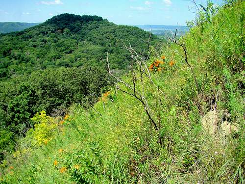
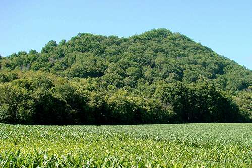
Some of the best hiking in Wisconsin is found along the Mississippi River at Perrot State Park. It’s not that the state has any shortage of beautiful scenery, but it is hard to find many locations with so many steep and rugged small peaks concentrated in close proximity. Three of the state’s 71 ranked summits are found in the park. At the center of all the summits is Perrot Ridge, with Reed’s Peak a scenic part of Perrot Ridge. Many prefer to separate the two as different summits, but they are really just two points on the same ridge. Perrot Ridge, shown on many topo maps at 1,157 feet, is usually not considered a ranked summit. On the other hand, a few other topo maps show it as 3 feet higher (1,173 feet) than nearby Brady’s Bluff, which would then make it a ranked summit. The reader can draw their own conclusions. The bottom line is that Perrot Ridge offers great hiking, with some limited scrambling prospects on both Perrot and (especially) Reed’s Peak. The summit view of the Mississippi River some 500 feet below makes any hike worth the effort.
Perrot State Park is located in that area of Wisconsin called the “Driftless Area”, which escaped the ravages of the last major glacier that covered much of the region to the north and northeast, thus preserving the very scenic bluffs and peaks along the Mississippi River. The sedimentary rock that forms the many bluffs and rock outcroppings include various sandstones and dolomites. The region has been covered with oaks, maples, walnut, hickory, birch and conifers.
Wildlife seen in the park includes deer, raccoons, fox, muskrat, mink, beavers and weasels. Bears are rarely, if ever seen there anymore. Turtles, frogs and snakes are common along the river. Some of the more common variety of snakes includes bull snakes, hog-nose snakes, blue racers, fox snakes, garter snakes and timber rattlesnakes. Though the rattlesnakes are not abundant at the state park, the careful hiker will keep watch for their presence. Over 100 varieties of birds make the park their home in the summer, which makes it a popular stop along the Great Wisconsin Birding and Nature Trail.
The park was named for French explorer Nicolas Perrot, who wintered there with a group of men from 1685-1686. While islands are not at all unusual for the Mississippi River, Trempealeau Mountain, an island peak at the confluence with the Trempealeau River, is rather unusual for the Mississippi River valley, as it rises close to 400 feet out of the river. Centuries ago, the Native Americans of the area considered Trempealeau Mountain to be a sacred place. Also of historical interest are the effigy mounds built by native tribes many centuries ago. Those mounds are still visible in the area.
Perrot State Park

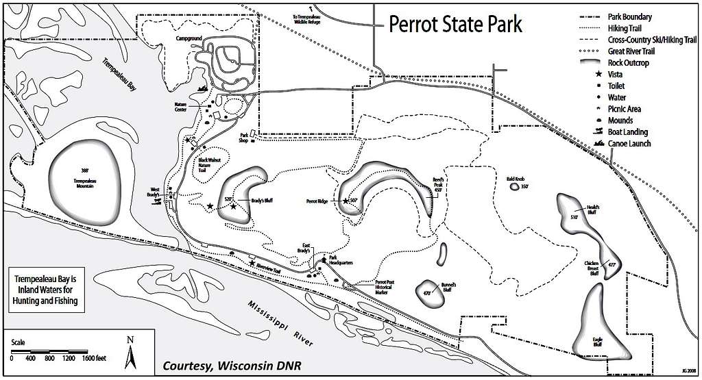
Covering 1,270 acres at the confluence of the Mississippi and Trempealeau rivers, Perrot State Park offers excellent hiking, skiing, mountain biking, kayaking, canoeing, fishing and extensive camping opportunities. There are over 22 miles of trails in the state park, plus the 24-mile Great River State Trail is adjacent to the park. The Wisconsin DNR provides a link for the trail descriptions here:
Besides the summit views from the peaks in the state park, there are wildlife observation platforms available. Leashed pets are allowed in the park, with certain areas off-limits to pets.
Getting There
Perrot State Park is on the north edge of the town of Trempealeau, Wisconsin, which is on Highway 35, about 22 miles east of Winona, Minnesota or about 23 miles north of LaCrosse, Wisconsin on Highway 35.
Once in the town of Trempealeau, follow Highway 35, which becomes Main Street. Turn south on First Street, which soon becomes South Park Road. Abundant signs in the park will direct you to the office and the trailheads.
Route Information
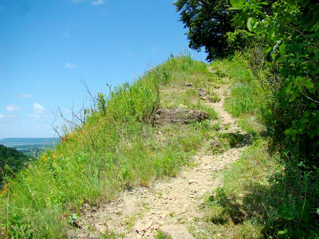
Free trail maps are available at the park headquarters. The Perrot Ridge trailhead begins next to the park headquarters, and also serves as one of the trailheads for Brady’s Bluff. The trails branch a short distance into the forest and are well-marked. For those who enjoy trails through a lush forest canopy, this is a good trail, with a majority of the trail being quite shady (in season, of course). As you ascend, the trail gets steeper and you will encounter some open areas and even a few stairs. Near the summit of Perrot Ridge, the trail is almost a scramble for just short way.
Once on the ridge crest, the trail is easy and drops until it passes just behind the summit of Reed’s Peak. At each end of Reed’s Peak summit area, are narrow unofficial trails that will lead hikers to rocky areas where you can scramble to the summit of Reed’s Peak for mostly unobstructed views of the summits and river valleys in the region. While hiking the Perrot Ridge loop, you will encounter ski trails. These differ from the regular hiking loop in that they are wider, gentler, grassy and smooth. You are welcome to hike on them also, though they don’t seem to get as much hiking traffic.
The map on this page shows the state park trail system. You may download the map by clicking on this link: Perrot State Park Trails Map
Red Tape


Perrot State Park, like all Wisconsin state parks, requires a vehicle admission sticker – whether a daily permit or an annual. These can be purchased at the park office. If you choose to camp at the park, you will also need to make arrangements at the office. Be advised that they have strict rules against bringing your own firewood into the park. If you are a skier, you will have to have a state trail pass. Hunters and fishers will also need appropriate licenses as well. For more up-to-date information, you may call:
(608) 534-6409, or visit their website at: Perrot State Park
When to Climb
The park is open to visitors all year long, but this does not mean that trail conditions on Perrot Ridge and Reed’s Peak are ideal all the time. Adverse weather, deep snow or summer lightning will provide incentive for the wise hiker to plan a more appropriate time. For more information on the area weather, click on the link below:
Perrot State Park Weather Forecast & Conditions
Wisconsin hunting seasons could affect hiking safety also. The time period between Thanksgiving and New Year’s Day are the busiest for hunting. For more information, click on the link below:
Perrot State Park Hunting Guide
Camping
Camping is available at Perrot State Park, with 102 campsites. Flush toilets and showers are located in the campground area. Campfires are permissible, but one must purchase their firewood from the park store. Ice and other supplies are also available from the store.
There are also accessible cabins for people with disabilities.
Camping reservations may be made online or by calling (888) 947-2757
For more information on camping rules, click on this link:
Perrot State Park Camping Rules
Other Information
The state park promotes recreation in many ways, including providing equipment for check-out. This includes volleyballs, Frisbees, horseshoes and bocce balls. For those who like to adventure, canoes and kayaks, along with paddles and life jackets, are available for rental. In season, snowshoes are also available to rent.