
-
 5280 Hits
-
 79.77% Score
-
 11 Votes
|
|
Mountain/Rock |
|---|---|
|
|
37.66761°N / 107.57371°W |
|
|
San Juan |
|
|
Hiking, Mountaineering, Scrambling |
|
|
Summer, Fall |
|
|
13682 ft / 4170 m |
|
|
Overview
 Peak Seven
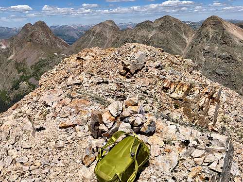 Summit of Peak Seven
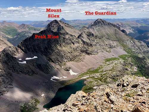
Peak Seven is a remote bicentennial (among the highest 200 in Colorado) peak located in the Weminuche Wilderness. The peak offers solitude, beauty and a pretty nice scramble. It combines nicely with other nearby peaks, e.g. Peak Eight (unranked), Peak Nine, Storm King, Mount Silex and The Guardian.
Peak Seven is the northernmost peak of Needles proper and part of the Storm King Peak Quad. It is possible to ascend this peak as a one day trip, but this requires a long mileage. I recommend a backpacking experience.
The peak is located near the continental divide, and the drainage from Leviathan Creek eventually ends up in San Juan River, Colorado River, and Pacific Ocean. A part of the approach trail if coming from Beartown goes along Continental Divide Trail.
Colorado Rank: 158
Parent Lineage: Peak Six
Wilderness: Weminuche
Class: 3
Nearby Mountains:
- Peak Eight (unranked) 0.44 miles
- Peak Nine 0.76 miles
- Peak Six 0.82 miles
- Storm King Peak 0.98 miles
- Leviathan Peak 1.02 miles
- East Trinity 1.16 miles
- Trinity Peak 1.26 miles
- Vallecito Mountain 1.27 miles
- Mt. Silex 1.41 miles
- Peak Five 1.44 miles
- West Trinity 1.52 miles
- Jagged Mountain 1.63 miles
- The Guardian 1.85 miles
- Peak Ten 1.88 miles
- Peak Four 1.93 miles
- Peak Three 1.99 miles
- Vestal Peak 2.18 miles
- Peak One 2.24 miles
Getting There
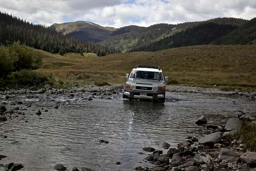 Crossing Rio Grande
 Hunchback Pass and The Guardian peaking in the distance
Driving Directions to Beartown and Hunchback Pass TH (this section of the trail is also Continental Divide Trail): The road is in a pretty bad condition, especially close to the trailhead. Expect about 2.5 hrs drive from Silverton (some sections you will be driving only 1-2 miles per hour).
From Silverton drive on County Road 2 to Howardsville and turn here onto FR 589 marked for Cunningham Gulch and Stony Pass. You have to options here: stay lower or take a higher road for the Old Mine Tour, it does not matter which road you take since they both connect later on. At the point where these 2 roads come together, take a left turn for Stony Pass - well marked.
The road climbs steeply and is narrow at some sections making travel difficult if vehicles coming from the opposite directions (often one car has to back up to spot wide enough where vehicles can pass). Stony Pass is a pretty area, lots of wildflower in the summer, and access to several 13ers. The descent from Stony Pass towards Pole Creek seems dragging, the crossing over the stream can be problematic early in the season. There are great campsites in this area. After crossing Pole Creek, the road goes steeply up and then splits with right fork heading towards Beartown/Kite Lake and left fork towards Creede - again well marked.
Soon, you will be crossing the Rio Grande - it is usually not much deeper than Pole Creek, but wider. It is an experience to drive your car through the Rio Grande River! Some people choose to drive from Creede side, but I think the road is tougher from the east side.
From the Rio Grande crossing, continue on Beartown road for about 5.5 miles. The first section could be muddy with potholes and big puddles. Once you reach the Bear Creek crossing, the road becomes rougher, with lots of loose rocks and towards the end steep. If your vehicle is having trouble, park at the Bear Creek and walk the last mile on the road (I usually drive this section with a speed of 1 mile per hour anyway, so walking may be a better option).
Hunchback Pass Trailhead is well marked, there is a parking spot for 2 cars right there and several more below and above.
Beartown is just a site, there is nothing there! Buy all your supply prior to the trip. Beartown boomed in 1893 when a rich strike brought about 400 prospectors into the area, but it did not last long. They mined Sylvanite.
Other options include longer backpacking approaches and combining different trails in the Weminuche Wilderness. You could cross over from Trinities and Vestal Peak, or from Jagged Mountain, etc.
I chose a loop to investigate two different basins: Stormy Gulch along Trinity Creek (I have been there before and return via Leviathan Creek Basin, both basins eventually meet with Vallecito Creek Trail and higher up Continental Divide Trail, which takes you back to Hunchback Pass Trailhead.
Route
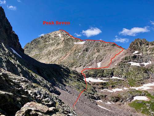
 Peak Seven
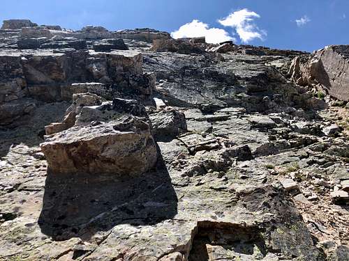 Peak Seven - consistency of the route higher up
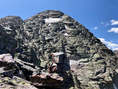
I believe there are many ways to reach a summit of a mountain. I chose the easiest one since the peak is remote, I logged over 22 miles in one day and over 8,000 feet in elevation gain. Even this "easy route" involved a lot of class 3 scrambling.
I used north ridge for the climb and the route finding was obvious. There were a few cairns lower down on the ridge, higher up when the slopes became steeper, it was easy to figure out the scramble. The summit has great views, Trinities appear so majestic. There was a small cairn and a summit register.
Red Tape
 Mount Silex and The Guardian from the summit of Peak Seven
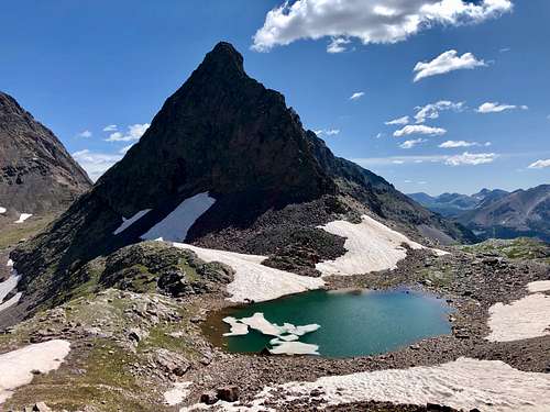 Peak Eight as seen from the north ridge of Peak Seven
The peak is located within Weminuche Wilderness, so wilderness rules apply. Weminuche Wilderness is the largest Wilderness area in Colorado.
Follow the seven standard Leave No Trace principles while in the wilderness:
- Plan Ahead and Prepare
- Travel and Camp on Durable surfaces
- Dispose of Waste Properly
- Leave what you Find
- Minimize campfire impacts
- Respect Wildlife
- Be Considerable of Other Visitors.
Wilderness Specific Regulations:
Group size is limited to no more than 15 people per party.
Camping is prohibited within 100 feet of any water source.
Camping and all campfires are prohibited at the following locations:
1. within 200 feet of Archuleta Lake, Fourmile Lake, and West Ute Lake
2. within 1/2 mile of the north shore and 1/4 mile of other shores of Emerald Lake
3. within 1/4 mile of Little Emerald Lake
4. between the shore and Flint and La Osa Trails at Flint Lake; and within 200 feet of the west and north shores
5. in Needle Creek drainage at Twin Lakes
6. in the hot springs area at West Fork (Rainbow)
Campfires are also prohibited in all of Needle Creek Drainage (including Chicago Basin) and Vestal Basin.
Do not shortcut switchbacks.
Pets must be under verbal control or leashed at all times.
Disposal of human waste and wash water is prohibited within 100 feet of any water source.
As with all designated Wilderness areas, mechanical transportation (including wagons, game carts, wheelbarrows, bicycles, or other vehicles) is prohibited.
When to Climb
This peak is very remote. Winter would mean a very long approach through avalanche-prone terrain. The best time to reach this peak is summer and early fall.
Camping
There is a plentitude of backpacking and camping. Nice campsites are along Vallecito Creek, in Stormy Gulch along Trinity Creek, along the unnamed lake just below Peak Seven, Balsam Lake on the west side of Peak Seven.
There is also camping at the Hunchback Pass Trailhead and along the Beartown road.