
|
|
Mountain/Rock |
|---|---|
|
|
60.74341°N / 148.72746°W |
|
|
Mountaineering |
|
|
Summer |
|
|
3720 ft / 1134 m |
|
|
This is a challenging climb for anyone spending a day in Whittier, AK, and I climbed it August 24, 2019, while waiting for a Princess cruise to begin. The climb is approximately 7 miles roundtrip from the cruise ship terminal and gains about 3,700' elevation. I climbed it in a little over 7 hours and an ice ax and crampons are going to be needed year-round for this mountain due to a portion of travel over the Western side of Whittier Glacier. The route involves fording the swiftly flowing Whittier Creek near the campground at the start and finish of the climb and the ice ax can be valuable in keeping your balance against the icy waters! I appreciate a write up of the basic route provided by William Finley at akmountain.com from when he climbed Bard Peak in 2007. Bard Peak is misspelled on the USGS map as Baird Peak
Getting There
Getting to Whittier can be a challenge! I spent 20 hours there during a cruise port call. If you are approaching from the Anchorage area, there is a choice between rail or highway and since both share the same tunnel, scheduling is a requirement both ways.
There is parking for the port before you reach the campground and I walked from the pier where our ship was docked over to the campgrounds initially along the Whittier creek, but on return used the road access for campers which is better.
Route
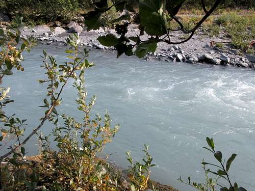
The climb begins with a ford of Whittier creek near the campground. I searched for a possible dry crossing upstream but ended up coming back and trying to find the most reasonable ford point by the campground where the creek broadens into several forks which could be more safely crossed. On this occasion, someone had strung a rope across the creek at a place where it was over 3 feet deep and it was very helpful. It was located near the first couple of campsites.
Then, you head upstream to the larger of two small streams feeding into the creek. This is where the bushwhack begins for perhaps 30 - 45 minutes hopping from slippery rock to slippery rock up the streambed to avoid more thick brush on either side. Eventually, I reached several outcropping ridges on the right side of the stream that headed up toward the right-hand side of the Whittier Glacier high above. These ridges keep the bushwhack to a minimum as you ascend a series of rocky outcrops to the eventual meadows above tree line.
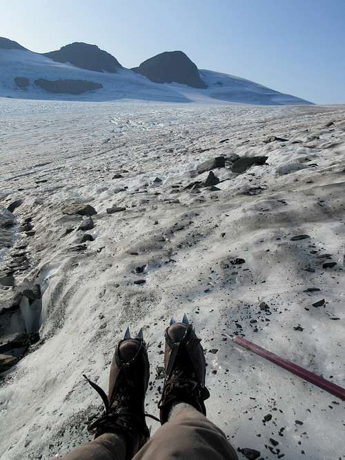
When you reach the glacier, put on your crampons for about 50 minutes of travel weaving about to avoid numerous crevasses.
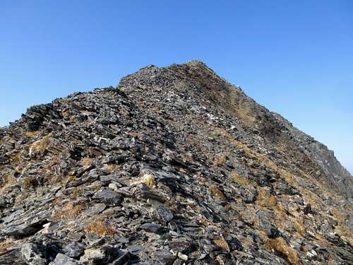
I went almost to the end of the Glacier (head for the notch) before heading up to climb the steep ridge on the right leading to the upper ridge between Shakespears Shoulder and Bard Peak.
From that ridge, it was a short scramble to the summit since I climbed it closer to Bard Peak than Shakespears shoulder.
Red Tape
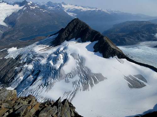 Shakespears shoulder from Bard Pk
There is no red tape involved to climb this mountain.
When to Climb
Probably most of the year when properly equipped with ice ax and crampons although winter climbing has added difficulties of fording the creek.
Camping
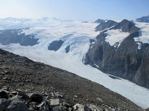 view South from Bard Pk
Add Camping text here.